Intersection of a geological fault with the Earth's surface
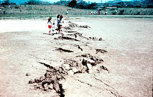
Along the Motagua Fault trace (1976 Guatemala earthquake) where it crosses the Gualán soccer field. This zigzag type of fault trace is known as "mole track", which is best developed in hard-packed, brittle surface materials.The San Andreas fault trace runs along the base of the Temblor Range of mountains near Bakersfield, California. (The fault trace is a linear feature to the right of the mountain ridge.)
A fault trace describes the intersection of a geological fault with the Earth's surface, which leaves a visible disturbance on the surface, usually looking like a crack in the surface with jagged rock structures protruding outward. The term also applies to a line plotted on a geological map to represent a fault. These fractures tend to occur when a slip surface expands from a fault core, especially during an earthquake. This tends to occur with fault displacement, in which surfaces on both sides of a fault, known as fault blocks, separate horizontally or vertically.[1]
^Torabi, Anita; Berg, Silje Støren (2011-08-01). "Scaling of fault attributes: A review". Marine and Petroleum Geology. 28 (8): 1444–1460. Bibcode:2011MarPG..28.1444T. doi:10.1016/j.marpetgeo.2011.04.003. ISSN 0264-8172.
A faulttrace describes the intersection of a geological fault with the Earth's surface, which leaves a visible disturbance on the surface, usually looking...
drainage system and others, which created clear faultingtrace that people can easily observe. Fault creep activities had been continuously tracing as...
located on the faulttrace and shows a NW-SE-elongated shape, ‘Lanalhue Fault Zone (LFZ)’ stands as appropriate name for the here discussed fault zone. The...
the Red River which runs through the valley eroded along the faulttrace. The Red River Fault was a sinistral strike-slip shear zone until Miocene times...
the fault runs through the Carrizo Plain, a long, treeless plain where much of the fault is plainly visible. The Elkhorn Scarp defines the faulttrace along...
Transform Fault and Cayman trench, which run under the Caribbean Sea. Its western end appears not to continue further than its surface trace, where it...
the Highland Boundary Fault can be traced from Ireland to the region of Greenock. In these areas, the Highland Boundary Fault is seen to be dividing...
upper section of the Margaree River follows the trace of the fault. Evidence shows movement in this fault dating back to the Ordovician period when it was...
described by strike and dip, including sedimentary bedding, fractures, faults, joints, cuestas, igneous dikes and sills, metamorphic foliation and fabric...
In computing, a segmentation fault (often shortened to segfault) or access violation is a fault, or failure condition, raised by hardware with memory protection...
offset or gap of approximately 420 kilometres (260 mi) along the main faulttrace. The Cayman spreading ridge shows a long-term opening rate of 11–12 mm/yr...
Bay, where the San Gregorio intersects the San Andreas Fault. Most of the San Gregorio faulttrace is located offshore beneath the waters of Monterey Bay...
Earth's crust. Ground fissures can form naturally, such as from tectonic faulting and earthquakes, or as a consequence of human activity, such as oil mining...
kilometers. A partial visualization of an active faulttrace that aligns with the present-day Sagaing Faulttrace was recorded by Fritz Noetling, a geologist...
The Ramapo Fault zone is a system of faults between the northern Appalachian Mountains and Piedmont areas to the east. Spanning more than 185 miles (298 km)...
are much more magnetic than the carbonates; this has been used to trace the fault with aeromagnetic techniques although the igneous rocks also reduce...
surface expression of the fault plane exists or where an ocean covers the faulttrace. A simple example of a successful test of the hypothesis of sea floor...
Clarence fault. It takes its name from the Waiau Toa / Clarence River, which follows the faulttrace in the northeastern section of the fault. It is formed...
Hayward Fault shares the same relative motions of the San Andreas. As with portions of other faults, a large extent of the Hayward Faulttrace is formed...
A transform fault or transform boundary, is a fault along a plate boundary where the motion is predominantly horizontal. It ends abruptly where it connects...
Iwaki city. It mainly consists of a trace of three separate striations. The fault was first mapped by the Active Fault Research Group in 1991 as a complex...
the first to research the fault in 1936; He found a lava flow (Pliocene age) that covered the northern end of the faulttrace where the Little Kern and...
changes direction to a mainly SSE-dipping faulttrace of the Manawahe Fault. At this southern end of the fault there is an area of Manawahe dacite that...
 Global Information