Transform fault zone pull-apart basin on the floor of the Caribbean Sea
False-color image of the Cayman Trough, created from digital databases of seafloor and land elevations.Mid-Cayman spreading centre as part of the trough, on the western edge of the Gonâve Microplate.
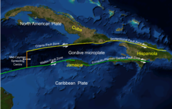
The Cayman Trough (also known as the Cayman Trench, Bartlett Deep and Bartlett Trough) is a complex transform fault zone pull-apart basin which contains a small spreading ridge, the Mid-Cayman Rise, on the floor of the western Caribbean Sea between Jamaica and the Cayman Islands.[1] It is the deepest point in the Caribbean Sea and forms part of the tectonic boundary between the North American Plate and the Caribbean Plate. It extends from the Windward Passage, going south of the Sierra Maestra of Cuba toward Guatemala. The transform fault continues onshore as the Polochic-Motagua fault system, which consists of the Polochic and Motagua faults.[2] This system continues on until the Chiapas massif where it is part of the diffuse triple junction of the North American, Caribbean and Cocos plates.[3]
The relatively narrow trough trends east-northeast to west-southwest and has a maximum depth of 7,686 metres (25,217 ft). Within the trough is a slowly spreading north–south ridge which may be the result of an offset or gap of approximately 420 kilometres (260 mi) along the main fault trace. The Cayman spreading ridge shows a long-term opening rate of 11–12 mm/yr.[4] The eastern section of the trough has been named the Gonâve Microplate. The Gonâve plate extends from the spreading ridge east to the island of Hispaniola. It is bounded on the north by the Oriente and Septentrional fault zones. On the south the Gonâve is bounded by the Walton fault zone, the Jamaica restraining bend and the Enriquillo-Plantain Garden fault zone. The two bounding strike slip fault zones are left lateral. The motion relative to the North American Plate is 11 mm/yr to the east and the motion relative to the Caribbean Plate is 8 mm/yr.[4] The western section of the trough is bounded to its south by the Swan Islands Transform Fault.[5]
During the Eocene the trough was the site of a subduction zone which formed the volcanic arc of the Cayman Ridge and the Sierra Maestra volcanic terrain of Cuba to the north, as the northeastward-moving Caribbean Plate was subducted beneath the southwest-moving North American Plate, or as some researchers contend, beneath a plate fragment dubbed the East Cuban Microplate.[6][failed verification]
In 2010 a UK team from the National Oceanography Centre in Southampton (NOCS), equipped with an autonomously controlled robot submarine, began mapping the full extent of the trench and discovered black smokers on the ocean floor at a depth of 5 km (16,000 ft), the deepest yet found.[7][8][9] In January 2012, the researchers announced that water exits the vents at a temperature possibly exceeding 450 °C (842 °F), making them among the hottest known undersea vents. They also announced the discovery of new species, including an eyeless shrimp with a light-sensing organ on its back.[10]
^Einsele, Gerhard (2000). Sedimentary Basins: Evolution, Facies, and Sediment Budget (2nd ed.). Springer. p. 630. ISBN 978-3-540-66193-1.
^Lyon-Caen, H.; Barrier, E.; Lasserre, C.; Fraco, A.; Arzu, I.; Chiquin, L.; Chiquin, M.; Duquesnoy, T.; Flores, O.; Galicia, O.; Luna, J.; Molina, E.; Porras, O.; Requena, J.; Robles, V.; Romero, J.; Wolf, R. (2006). "Kinematics of the North American-Caribbean-Cocos plates in Central America from new GPS measurements across the Polochic-Motagua fault system". Geophysical Research Letters. 33 (L19309). Bibcode:2006GeoRL..3319309L. doi:10.1029/2006GL027694. S2CID 3161221.
^Guzmán-Speziale, Marco (2010). "Beyond the Motagua and Polochic faults: Active strike-slip faulting along the Western North America-Caribbean plate boundary zone". Tectonophysics. 496 (1–4): 17–27. Bibcode:2010Tectp.496...17G. doi:10.1016/j.tecto.2010.10.002.
^ abDeMets, C.; Wiggins-Grandison, M. (2007). "Deformation of Jamaica and motion of the Gonâve microplate from GPS and seismic data". Geophys. J. Int. 168 (1): 375–6. Bibcode:2007GeoJI.168..362D. doi:10.1111/j.1365-246x.2006.03236.x.
^Rosencrantz M.; Mann P. (1991). "SeaMARC II mapping of transform faults in the Cayman Trough, Caribbean Sea". Geology. 19 (7): 690–691. Bibcode:1991Geo....19..690R. doi:10.1130/0091-7613(1991)019<0690:SIMOTF>2.3.CO;2.
^Sigurdsson, H; S. Kelley; R.M. Leckie; S. Carey; T. Bralower; J. King (2000). "Chapter 20: History of circum-Caribbean explosive volcanism: 40Ar/39Ar dating of tephra layers". In Leckie, R.M.; Sigurdsson, H.; Acton, G.D.; Draper, G. (eds.). Sci. Results. Proc. ODP. Vol. 165. College Station, Texas: Ocean Drilling Program. doi:10.2973/odp.proc.sr.165.2000. ISSN 1096-7451.
^Carpenter, Jennifer (August 9, 2008). "Sub to make deep Caribbean dive". BBC Science News. Retrieved August 9, 2008.
^"World's deepest undersea vents discovered". LiveScience.com. April 11, 2010. Retrieved April 12, 2010.
^"Latest news". RRS James Cook Voyage 44. Retrieved January 14, 2012.
^McGrath, Matt (January 12, 2012). "Cayman vents are world's hottest". BBC News. Retrieved January 14, 2012.
The CaymanTrough (also known as the Cayman Trench, Bartlett Deep and Bartlett Trough) is a complex transform fault zone pull-apart basin which contains...
of an undersea mountain range called the Cayman Ridge (or Cayman Rise). This ridge flanks the CaymanTrough, 6,000 m (20,000 ft) deep which lies 6 km...
8 mi). The islands are located on the Cayman Rise which forms the northern margin of the CaymanTrough. The trough is the deepest point in the Caribbean...
encounter with an unidentified submerged object and sinks near the CaymanTrough. With Soviet ships moving in to try to salvage the sub and a hurricane...
000 km2 (1,063,000 sq mi). The sea's deepest point is the CaymanTrough, between the Cayman Islands and Jamaica, at 7,686 m (25,217 ft) below sea level...
located just south of Grand Cayman in the Caribbean, on the north side of the Mid-Cayman Spreading Centre in the CaymanTrough. Approximately 24 kilometres...
of 2,216 metres (7,270 ft). Its basins include the Mexico Basin, the CaymanTrough, the Yucatan Basin, the Columbian Basin, the Venezuelan basin and the...
boundary, which extends west between Cuba and Hispaniola through the CaymanTrough to the coast of Central America. The trench is 800 kilometres (497 mi)...
The Cayman Ridge is an undersea mountain range on the northern margin of the CaymanTrough in the Caribbean Sea. It extends from the Sierra Maestra in...
the CaymanTrough, north of Jamaica and west of the southern tip of Cuba, with the epicenter being 80 miles (130 km) ESE of Cayman Brac, Cayman Islands...
Central America. The Motagua Fault is an onshore continuation of the CaymanTrough which forms part of the tectonic boundary between the North American...
construction of the rift valley walls along much of the Mid-Cayman Rise, and the inner wall of the CaymanTrough fracture zone immediately to the north – investigating...
the critical point of the fluid at that salinity. A vent site in the CaymanTrough named Beebe, which is the world's deepest known hydrothermal site at...
through the Caymantrough along the Swan Islands Transform Fault before joining the southern boundary of the Gonâve Microplate. East of the Mid-Cayman Rise this...
Rico trench along the northern coast of Puerto Rico and on through the CaymanTrough to the coast of Central America. Approximately 50 miles ESE of Fajardo...
fault, forming part of the southern boundary to the CaymanTrough. It extends from the Mid-Cayman Rise spreading center in the west to Jamaica in the...
American Plate. It runs along the southern boundary of the CaymanTrough from the Mid-Cayman Rise spreading center in the east, to Guatemala in the west...
of supercriticality at the vent site. A further site, Beebe, in the CaymanTrough, is thought to display sustained supercriticality at the vent orifice...
Caledonia trough, which is an extensional sedimentary basin related to the Tonga-Kermadec subduction zone. Additionally, the CaymanTrough, which is a...
diverse reef structure, vibrant marine life and close proximity to the CaymanTrough. Oracabessa has a long history as a Jamaican fishing village, with Oracabessa...
Present) Collision of Cuba with Florida Platform and Opening of the CaymanTrough. PALEOMAP Project http://www.scotese.com/caribanim.htm Sigurdsson H...
Graben Western Quebec Seismic Zone United States Caribbean and Mexico CaymanTrough Chixoy-Polochic Fault Enriquillo–Plantain Garden fault zone (Cuba) Gulf...
The eastern shoreline of Oracabessa is located on the edge of the CaymanTrough with walls that begin at 60 feet and drop down to over 150 feet. These...
 Global Information