View from Christiansø to FrederiksøÆrtholmene around 1900
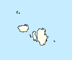
Ertholmene (formerly spelled Ærtholmene) is a small archipelago in Denmark. The largest island is Christiansø, and its name often refers to the entire archipelago.[2] Ertholmene is situated 18 kilometres (11 mi) northeast of Gudhjem, Bornholm, and contains Denmark's easternmost point.[2] Two of its islands, Christiansø and Frederiksø, are inhabited,[2] and their combined permanent population (as of 2024[update]) is 91.[3] The archipelago has a total area of 39 hectares (96 acres). Its name is derived from the Danish for "pea islands".
Historically an important navy location, the fortress closed in 1855. Since then there has been no operable military infrastructure on the archipelago, but it remains under the formal administration of the Ministry of Defence, which employs 25 to 30 people for maintaining the islands' civilian infrastructure, museum and historical buildings.[4] Today the economy of Ertholmene is almost entirely based on tourism, with tens of thousands of visitors each year, the majority on day-trips from Bornholm during the summer months.[4] The archipelago's buildings and nature are protected by law, and access to the uninhabited islands is restricted.[5]
^"Ertholmene". Ramsar Sites Information Service. Retrieved 25 April 2018.
^ abcJørgensen, Jens Riis (7 December 2016). "Ertholmene". Den Store Danske. Gyldendal. Retrieved 24 April 2020.
^"Population 1. January by islands". StatBank Denmark. Statistics Denmark. Retrieved 12 February 2024.
^ ab"Christiansø Administration". fmn.dk. Retrieved 8 March 2023.
^"Bekendtgørelse om fredning af øgruppen Ertholmene og omliggende søterritorium". retsinformation.dk. 20 November 1984. Retrieved 8 March 2023.
Ertholmene (formerly spelled Ærtholmene) is a small archipelago in Denmark. The largest island is Christiansø, and its name often refers to the entire...
from 270 to the current 98 on Monday January 1, 2007. The archipelago of Ertholmene is not part of any municipality or region but is administered by the Ministry...
existing municipalities or formed new ones were made by plebiscites. Ertholmene, so named because its islands are small as a pea (Danish: ert, (modern)...
point is Østerskær at 15° 11' 55" eastern longitude. This is in the small Ertholmene archipelago 18 kilometres (11 mi) north-east of Bornholm. The distance...
coats of arms, but they do have modern logos. The small archipelago of Ertholmene to the northeast of Bornholm is not part of any region or municipality...
Zealand. It serves a population of under 40,000 (2017) on Bornholm and Ertholmene. The hospital also physically hosts a mental health centre, which however...
happens to contain the national capital. The region does not include the Ertholmene archipelago which is situated to the northeast of Bornholm. The gross...
northern Europe, testament to the importance of its location. Bornholm and Ertholmene comprise the last remaining Danish territory in Skåneland east of Øresund...
Storebælt, including Zealand, Amager, Lolland, Falster, Møn, Bornholm, and Ertholmene. From a linguistic and historical point of view the term refers to the...
authorities used the modern Danish spelling, Ringkøbing. The archipelago Ertholmene, located northeast of Bornholm, have never been a part of a municipality...
been a part of the tax levied by the former counties. The archipelago of Ertholmene is not part of any municipality, but is administered by the Ministry of...
Composed of a regular tax rate of 18% and a military tax of 1.5%. In Ertholmene, which is not part of a municipality, there is no municipal tax. Plus...
in a prison called "the Balloon" on the islet Fredriksø, part of the Ertholmene islands north of Bornholm. In 1840, after the abolition of exile as a...
 Global Information