Draa River fleuve du Draa (French) Río Draa (Spanish)
Course of the Draa [1] [dead link]
Native name
Asif en Dra(Berber languages)
ⴰⵙⵉⴼ ⵏ ⴷⵔⴰ(Berber languages)
واد درعة(Moroccan Arabic)
Location
Countries
Morocco
Physical characteristics
Source
Dadès River
2nd source
Imini River
Mouth
Atlantic
Length
1100km
Basin features
Progression
Southeast
Ramsar Wetland
Official name
Embouchure de l'oued Dr'a
Designated
15 January 2005
Reference no.
1477[1]
Ramsar Wetland
Official name
Moyenne Dr'a
Designated
15 January 2005
Reference no.
1482[2]
Dra is also the abbreviation for the constellation Draco.
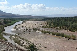
The Draa (Berber languages: Asif en Dra, ⴰⵙⵉⴼ ⴻⵏ ⴷⵔⴰ, Moroccan Arabic: واد درعة, romanized: wad dərʿa; also spelled Dra or Drâa, in older sources mostly Darha or Dara, Latin: Darat) is Morocco's longest river, at 1,100 kilometres (680 mi). It is formed by the confluence of the Dadès River and Imini River. It flows from the High Atlas mountains, initially south-eastward to Tagounite, and from Tagounite mostly westwards to its mouth in the Atlantic Ocean somewhat north of Tan-Tan. In 1971, the (El) Mansour Eddahabi dam was constructed to service the regional capital of Ouarzazate and to regulate the flow of the Draa. Most of the year the part of the Draa after Tagounite falls dry.
In the first half of the 20th century, the lowest course of the Draa marked the boundary between the French protectorate of Morocco and the area under Spanish rule.
The valley contains the Fezouata formations, which are Burgess shale-type deposits dating to the Lower Ordovician, filling an important preservational window between the common Cambrian lagerstätten and the Late Ordovician Soom shale.[3] In the fossilized fauna were numerous organisms previously thought to have died out after the mid-Cambrian.[4]
^"Embouchure de l'oued Dr'a". Ramsar Sites Information Service. Archived from the original on 30 May 2018. Retrieved 25 April 2018.
^"Moyenne Dr'a". Ramsar Sites Information Service. Archived from the original on 27 February 2017. Retrieved 25 April 2018.
^Van Roy, P.; Orr, P. J.; Botting, J. P.; Muir, L. A.; Vinther, J.; Lefebvre, B.; Hariri, K. E.; Briggs, D. E. G. (2010). "Ordovician faunas of Burgess Shale type". Nature. 465 (7295): 215–8. Bibcode:2010Natur.465..215V. doi:10.1038/nature09038. PMID 20463737. S2CID 4313285. Archived from the original on 2024-02-25. Retrieved 2024-02-24.
^Gill, Victoria (13 May 2010). "BBC News - Fossil find resolves ancient extinction mystery". BBC Online. British Broadcasting Corporation. Archived from the original on 2 February 2020. Retrieved 2 September 2015.
Atlantic Ocean after heavy rain. The DraaRiver in Morocco is Morocco's longest river, but its flow is irregular. The river is often dry for much of the year...
240 km DraaRiver - Morocco. 1100 km Moulouya River - Morocco. 520 km Oum Er-Rbia River - Morocco. 555 km Sebou River - Morocco. 496 km Chelif River - Algeria...
Agdz lies at the feet of Djebel Kissane and along the shores of the DraaRiver. Agdz is located about 65 kilometers south of Ouarzazate, 92 kilometers...
consisted of the area of Morocco between the Corridor of Taza and the DraaRiver, including sparse tribal lands. The official capital was Rabat. Despite...
and makes up a semi-desert buffer zone between Morocco proper at the DraaRiver and Western Sahara. The strip was under Spanish rule during much of the...
Imini River (Arabic: نهر اميني) is a river in Morocco. It flows from eastern Atlas Mountains and enters Ouarzazate River, which enters DraaRiver. It provides...
has been one of the arrival points at the annual Africa Eco Race. The DraaRiver flows through the commune, which has benefited from numerous water distribution...
200 individuals) settled in Morocco (mainly in the DraaRiver valley, between the Moulouya River, Tafilalt and Taourirt). Towards the end of the Almohad...
the regions to the south up to the DraaRiver, including the Anti-Atlas and the alluvial basin of the Souss River. The largest urban centres in the area...
respectively. Relic populations of the West African crocodile persisted in the Draariver until the 20th century. The Barbary macaque, a primate endemic to Morocco...
rivers in Algeria. This list is arranged west to east by drainage basin, with respective tributaries indented under each larger stream's name. Draa River...
An old spelling of DraaRiver Dara (disambiguation) This disambiguation page lists articles associated with the title Dara River. If an internal link...
used. On the margins of the Sahara Desert, the isolated oases of the DraaRiver valley and Tafilalt have relied on qanat water for irrigation since the...
Chebbi near Merzouga. This erg made of beautiful sand dunes is located in the Drâa-Tafilalet area about 45 km west of the small rural oasis town of M'Hamid...
(Assaka River) DraaRiver Dadès River Ouarzazate River Imini River Laou River Rhîs River Nekor River Kert River Río de Oro Moulouya River Za River Msoun...
14th century they had been established at Tagmadert in the valley of the DraaRiver.: 350 In the mid-15th century some of them established themselves at...
Predynastic periods. Tiya Ogooue River Valley Epona Elarmekora Kongo Boumba Lindili Kaya Kaya Akakus Jebel Uweinat The DraaRiver valley. Taouz. Akka Smara Twyfelfontein...
the Zaouia of Illigh [fr] established its influence from Souss to the DraaRiver, the marabout Sidi al-Ayachi took possession of the northwestern plains...
 Global Information