Districts of Botswana. The seven urban districts are not shown.
Category
Unitary State
Location
Republic of Botswana
Number
17 Districts
Populations
2,914 (Sowa) – 652,085 (Central District)
Areas
17 km2 (6.6 sq mi) (Orapa) – 142,076 km2 (54,856 sq mi) (Central District)
Government
District government
Subdivisions
Sub-district
Politics of Botswana
Constitution
Government
President
Mokgweetsi Masisi
Vice-President
Slumber Tsogwane
Cabinet of Botswana
Parliament
National Assembly
Speaker: Phandu Skelemani
Ntlo ya Dikgosi (House of Chiefs)
Constituencies
Judiciary
High Court of Botswana
Administrative divisions
Districts
Sub-districts
Villages
Elections
Recent elections
General: 2009
2014
2019
2024
Political parties
List of general elections in Botswana
Foreign relations
Minister of Foreign Affairs
Minister: Vincent T. Seretse
Diplomatic missions of / in Botswana
Passport
Visa requirements
Visa policy
Other countries
v
t
e
Botswana is divided into 10 administrative districts, two cities, five towns and 11 sub districts. These are administered by 16 local authorities (district councils, city councils or town councils).[1][2][3]
Administrative District
Capital
Population 2022
Population 2011
Area (km2)
Density 2011 (/km2)
Southern District
Kanye
240,544
215,775
28,470
7.5790
South-East District
Ramotswa
385,038
345,613
1,780
194.2
Kweneng District
Molepolole
387,703
304,549
31,100
9.793
Kgatleng District
Mochudi
121,411
91,660
7,960
11.515
Central District
Serowe
700,908
576,064
638,604
0.9020676
North-East District
Masunga
171,354
159,225
5,120
31.099
Ngamiland District
Maun
196,574
152,284
109,130
1.39544
Chobe District
Kasane
28,388
23,347
20,800
1.1225
Ghanzi District
Ghanzi
55,884
43,355
117,910
0.367696
Kgalagadi District
Tsabong
58,375
50,492
105,200
0.47996
Total
2,359,609
2,024,904
570,162
3.551454
^"2011 Population & Housing Census Analytical Report" (PDF). Archived from the original (PDF) on 30 October 2017. Retrieved 17 July 2017.
^"Botswana Government Ministries & Authorities". Archived from the original on 6 June 2017.
^"2022 Population and Housing Census Preliminary Results" (PDF). Statistics Botswana.
and 20 Related for: Districts of Botswana information
Botswana (English: Land of the Tswana; /bɒtˈswɑːnə/ , also UK: /bʊt-, bʊˈtʃw-/), officially the Republic ofBotswana (Setswana: Lefatshe la Botswana, [lɪˈfatsʰɪ...
development. Charles Hill Sub-District, Ghanzi Sub-District are the two sub districtsof the district. Nwetwe Pan Sub-districtsofBotswana "Sub-national HDI -...
Kweneng is one of the districtsofBotswana and is the recent historical homeland of the Bakwena people, the first group in Botswana converted to Christianity...
Kgatleng is one of the districtsofBotswana, coterminous with the homeland of the Bakgatla people. Its capital is Mochudi, the hometown of protagonist Precious...
The economy ofBotswana is currently one of the world's fastest growing economies, averaging about 5% per annum over the past decade. Growth in private...
district in southwest Botswana, lying along the country's border with Namibia and South Africa. The administrative center is Tsabong. The districtof...
The president of the Republic ofBotswana is the head of state and the head of government ofBotswana, as well as the commander-in-chief of the armed forces...
Botswana is a parliamentary republic in which the President ofBotswana is both head of state and head of government. The nation's politics are based...
The 2024 Botswana general election will be held to determine the composition of the 13th Parliament ofBotswana as well as local councils across the country...
List of hospitals in Botswana. There are 624 medical facilities in Botswana, including 26 public hospitals. Botswana had an estimated population of 2,352...
The Cabinet ofBotswana consists of the President, Vice President and all the Ministers and assistant ministers, the permanent secretary and deputy permanent...
capital and largest city ofBotswana with a population of 246,325 based on the 2022 census, about 10% of the total population ofBotswana. Its agglomeration...
Botswana is a landlocked country located in Southern Africa, north of South Africa. Botswana occupies an area of 581,730 square kilometres (224,610 sq mi)...
Botswana is divided into fifty-seven parliamentary constituencies. List of electoral districts by nation List of current members of the National Assembly...
following is a list of cities and towns or villages in Botswana with population of over 1,000 citizens in the year 2022. Capitals of the administrative...
Chobe District is an administrative district in the northern part ofBotswana, with the headquarters in Kasane. In 2001 it was merged with Ngamiland,...
Demographic features of the population ofBotswana include population density, ethnicity, education level, health of the populace, economic status, religious...
 Global Information
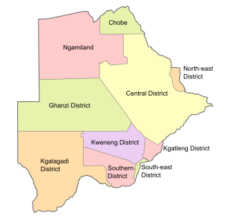 Districts of Botswana. The seven urban districts are not shown.