Global Information Lookup Global Information

Distance measuring equipment information
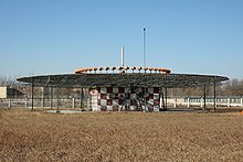

D-VOR/DME ground station
DME antenna beside the DME transponder shelter

In aviation, distance measuring equipment (DME) is a radio navigation technology that measures the slant range (distance) between an aircraft and a ground station by timing the propagation delay of radio signals in the frequency band between 960 and 1215 megahertz (MHz). Line-of-visibility between the aircraft and ground station is required. An interrogator (airborne) initiates an exchange by transmitting a pulse pair, on an assigned 'channel', to the transponder ground station. The channel assignment specifies the carrier frequency and the spacing between the pulses. After a known delay, the transponder replies by transmitting a pulse pair on a frequency that is offset from the interrogation frequency by 63 MHz and having specified separation.[1]

DME systems are used worldwide, using standards set by the International Civil Aviation Organization (ICAO),[1] RTCA,[2] the European Union Aviation Safety Agency (EASA)[3] and other bodies. Some countries require that aircraft operating under instrument flight rules (IFR) be equipped with a DME interrogator; in others, a DME interrogator is only required for conducting certain operations.

While stand-alone DME transponders are permitted, DME transponders are usually paired with an azimuth guidance system to provide aircraft with a two-dimensional navigation capability. A common combination is a DME colocated with a VHF omnidirectional range (VOR) transmitter in a single ground station. When this occurs, the frequencies of the VOR and DME equipment are paired.[1] Such a configuration enables an aircraft to determine its azimuth angle and distance from the station. A VORTAC (a VOR co-located with a TACAN) installation provides the same capabilities to civil aircraft but also provides 2-D navigation capabilities to military aircraft.

Low-power DME transponders are also associated with some instrument landing system (ILS), ILS localizer and microwave landing system (MLS) installations. In those situations, the DME transponder frequency/pulse spacing is also paired with the ILS, LOC or MLS frequency.

ICAO characterizes DME transmissions as ultra high frequency (UHF). The term L-band is also used.[4]

Developed in Australia, DME was invented by James "Gerry" Gerrand[5] under the supervision of Edward George "Taffy" Bowen while employed as Chief of the Division of Radiophysics of the Commonwealth Scientific and Industrial Research Organisation (CSIRO). Another engineered version of the system was deployed by Amalgamated Wireless Australasia Limited in the early 1950s operating in the 200 MHz VHF band. This Australian domestic version was referred to by the Federal Department of Civil Aviation as DME(D) (or DME Domestic), and the later international version adopted by ICAO as DME(I).

DME is similar in principle to secondary radar ranging function, except the roles of the equipment in the aircraft and on the ground are reversed. DME was a post-war development based on the identification friend or foe (IFF) systems of World War II. To maintain compatibility, DME is functionally identical to the distance measuring component of TACAN.

  1. ^ a b c Annex 10 to the Convention on International Civil Aviation, Volume I – Radio Navigation Aids; International Civil Aviation Organization; International Standards and Recommended Practices.
  2. ^ Minimum Operational Performance Standards for Airborne Distance Measuring Equipment (DME) Operating Within the Radio Frequency Range of 960-1215 Megahertz; RTCA; DO-189; 20 September 1985.
  3. ^ Distance Measuring Equipment (DME)Operating Within the Radio Frequency Range of 960-1215 Megahertz; European Union Aviation Safety Agency; ETSO-2C66b; 24 October 2003.
  4. ^ "Appendix B: IEEE Standard Letter Designations for Radar Bands". Handbook of Frequency Allocations and Spectrum Protection for Scientific Uses (2nd ed.). National Academies of Sciences, Engineering, and Medicine. 2015. doi:10.17226/21774. ISBN 978-0-309-37659-4.
  5. ^ "Engineer exploded myths in many fields". 9 January 2013 – via The Sydney Morning Herald.

and 25 Related for: Distance measuring equipment information

Request time (Page generated in 0.893 seconds.)

Distance measuring equipment

Last Update:

In aviation, distance measuring equipment (DME) is a radio navigation technology that measures the slant range (distance) between an aircraft and a ground...

Word Count : 2366

VHF omnidirectional range

Last Update:

military aircraft. However, the TACAN distance measuring equipment is also used for civil purposes because civil DME equipment is built to match the military...

Word Count : 6461

Instrument landing system

Last Update:

height. Markers are largely being phased out and replaced by distance measuring equipment (DME). The ILS usually includes high-intensity lighting at the...

Word Count : 6142

Length measurement

Last Update:

Taximeter, measure usually includes a time component as well Tellurometer Travelling microscope Angular measuring instrument Altimeter, height Distance measuring...

Word Count : 3394

Airports Authority of India

Last Update:

locations along with 700 VOR/DVOR installations co-located with Distance Measuring Equipment (DME). 52 runways are provided with Instrument landing system...

Word Count : 2496

Initial approach fix

Last Update:

omnidirectional range (VOR), non-directional beacon (NDB), or distance measuring equipment (DME) fix. The initial approach fix may be collocated with the...

Word Count : 126

Flight management system

Last Update:

highest quality sensors. These include; Scanning DME (distance measuring equipment) that check the distances from five different DME stations simultaneously...

Word Count : 1946

Ayodhya Airport

Last Update:

Doppler Very-high frequency Omnidirectional Range (DVOR) and Distance Measuring Equipment (DME) from the first phase of the runway development only. Terminal...

Word Count : 2797

Wide Area Augmentation System

Last Update:

System (LAAS) Joint Precision Approach and Landing System (JPALS) Distance measuring equipment (DME) Instrument flight rules (IFR) Instrument landing system...

Word Count : 4014

Radio navigation

Last Update:

distance measuring equipment (DME) system.[citation needed] DME was identical to Gee-H in concept, but used new electronics to automatically measure the...

Word Count : 5305

Tape measure

Last Update:

A tape measure or measuring tape is a flexible ruler used to measure length or distance. It consists of a ribbon of cloth, plastic, fibre glass, or metal...

Word Count : 2957

Maharana Pratap Airport

Last Update:

airport is equipped with modern navigational and landing aids like Distance Measuring Equipment (DME), DVOR, and Non-Directional Beacon (NDB) and is equipped...

Word Count : 498

DME

Last Update:

edema Durable medical equipment Dashtop mobile equipment Diastatic malt extract, used in home-brewing Distance measuring equipment, used in aviation Dropping...

Word Count : 154

Airband

Last Update:

UHF range of 329.3–335.0 MHz with marker beacons at 75 MHz. Distance measuring equipment (DME) also uses UHF from 962 to 1150 MHz. Channel spacing for...

Word Count : 1503

Area navigation

Last Update:

used very high frequency omnidirectional radio range (VOR) and distance measuring equipment (DME) for estimating position; for oceanic operations, inertial...

Word Count : 1283

Index of aviation articles

Last Update:

control – CTAF – Cyclic Deep stall – Delta wing – Dihedral – Distance measuring equipment (DME) – Downwash – Drag – Drag-reducing aerospike – Drop zone...

Word Count : 1087

Gondia Airport

Last Update:

The main apron measures 100 m × 150 m. The airport is equipped with a Non-directional beacon (NDB), DVOR, Distance Measuring Equipment (DME) and Instrument...

Word Count : 562

List of IEC standards

Last Update:

Maritime navigation and radiocommunication equipment and systems – Marine speed and distance measuring equipment (SDME) – Performance requirements, methods...

Word Count : 17123

China Airlines Flight 676

Last Update:

at 15:27. The Airbus carried out an instrument landing system/distance-measuring equipment (ILS/DME) approach to runway 05L at Taipei Chiang Kai Shek Airport...

Word Count : 1973

Gautam Buddha Airport

Last Update:

the Gautam Buddha Airport; VHF omnidirectional range along a distance measuring equipment (DVOR/DME) and Required Area Navigation (RNAV/RNP). A non-directional...

Word Count : 1940

Marker beacon

Last Update:

such as VHF omnidirectional range (VOR) radial intersections, distance measuring equipment (DME), GPS, or radar fixes, to identify the position. FAA AIM...

Word Count : 1230

Tactical air navigation system

Last Update:

parts. Battle of Lima Site 85 (SAC TACAN captured March 1968) Distance measuring equipment Electronics technician Global Positioning System VHF omnidirectional...

Word Count : 1640

Surinam Airways Flight 764

Last Update:

omnidirectional range/distance measuring equipment) approach, the crew initiated an ILS/DME approach. ILS navigational equipment is normally more accurate...

Word Count : 1857

Faleolo International Airport

Last Update:

conflict between the aircraft's altitude and the functioning Distance Measuring Equipment, and their familiarity with the approach into Faleolo which caused...

Word Count : 1561

Concorde

Last Update:

instruments Dual automatic direction finder instruments Dual distance measuring equipment instruments Dual instrument landing systems Automatic flight...

Word Count : 23508

PDF Search Engine © AllGlobal.net