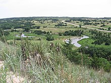
Looking downstream (east) from Nebraska Highway 97 crossingDismal River, Sandhills, and U.S. Route 83 in Thomas County.
The Dismal River is a winding 71.9-mile-long (115.7 km)[1] river in the state of Nebraska. It is formed by the confluence of two forks, one of which has its origins in Grant County and the other in Hooker County. The forks meet near Nebraska Highway 97 between Mullen and Tryon. From here the Dismal River flows east-southeast into Thomas County, crossing U.S. Highway 83 south of Thedford. Passing just south of the Nebraska National Forest (once the Dismal River National Forest), it turns slightly to the northeast before its confluence with the Middle Loup River just East of Dunning in Blaine County.
Most of the land along the river is privately owned and used for ranching. The water comes from the Ogallala Aquifer and boils up beneath the river in places, sometimes creating areas of quicksand.[2] Deer, coyotes, beavers, turkey and rattlesnakes inhabit the area along the river.
Though much of the river's length is unpopulated, the Dismal River Golf Course, designed by Jack Nicklaus, borders it south of Mullen.
^U.S. Geological Survey. National Hydrography Dataset high-resolution flowline data. The National Map Archived 2012-03-29 at the Wayback Machine, accessed March 30, 2011
^Guhman, Anne Irene, and Darryll T. Pederson (1992). "Boiling sand springs, Dismal River, Nebraska: Agents for formation of vertical cylindrical structures and geomorphic change". Geology. v.20, no. 1, pp. 8-10. Retrieved 2010-08-03.
The DismalRiver is a winding 71.9-mile-long (115.7 km) river in the state of Nebraska. It is formed by the confluence of two forks, one of which has...
The DismalRiver culture refers to a set of cultural attributes first seen in the DismalRiver area of Nebraska in the 1930s by archaeologists William...
The Great Dismal Swamp is a large swamp in the Coastal Plain Region of southeastern Virginia and northeastern North Carolina, between Norfolk, Virginia...
Platte River North Platte River South Platte River Lodgepole Creek Wood River Loup River North Loup River Calamus River Middle Loup RiverDismalRiver South...
pottery has also been found in some of the DismalRiver complex sites. Some of the people from the DismalRiver culture joined the Plains Apache in the Black...
The Dismal Swamp Canal is a canal located along the eastern edge of the Great Dismal Swamp in Virginia and North Carolina in the United States. Opened...
pottery has also been found in some of the DismalRiver complex sites. Some of the people of the DismalRiver culture joined the Kiowa Apache in the Black...
attributed to a new culture called the DismalRiver culture, or DismalRiver aspect, for its location on the DismalRiver basin of Nebraska, dated between 1650-1750...
Dismal Nitch is the name of a cove along the lower Columbia River in Washington state, notable as the Lewis and Clark Expedition's last campsite before...
artifacts of the DismalRiver culture and likely inhabited by early Apachean people. Cedar Point Village, declared "the most spectacular DismalRiver site in Colorado...
The Great Dismal Swamp maroons were people who inhabited the swamplands of the Great Dismal Swamp in Virginia and North Carolina after escaping enslavement...
and Trinchera Cave Archeological District. The DismalRiver culture was first seen in the DismalRiver area of Nebraska. Dated between AD 1650 and 1750...
DismalRiver National Forest was established as the DismalRiver Forest Reserve by the United States General Land Office in Nebraska on April 16, 1902...
Landmark. Of the 26 archaeological sites, most are from Apache of the DismalRiver culture of prehistoric, proto-historic and early historic periods from...
Eastern United States. The Great Dismal Swamp is in southeastern Virginia and northeastern North Carolina between the James River (Norfolk, Virginia) and the...
semi-nomadic people on the Central Plains along the bank of the Missouri River in Nebraska, Kansas, Iowa, and Missouri. They lived in elm-bark lodges while...
north of Heart River, encircled on the east and north by the Missouri and on the west by Yellowstone River down to the mouth of Powder River. The Lakota...
Missouri River and into North and South Dakota, where they adopted the horse culture. Having settled the Black Hills of South Dakota and the Powder River Country...
Industrial School Ionia Volcano Precontact peoples Central Plains Woodland DismalRiver Precontact communities Leary Site Ash Hollow Coufal Schultz site Signal...
Dismal Creek, a wildland in the George Washington and Jefferson National Forests of western Virginia, has been recognized by the Wilderness Society as...
000 people. They lived along the Loup (ickariʾ) and Platte (kíckatuus) river areas for centuries; however, several tribes from the Great Lakes began...
Canyon and Trinchera Cave Archeological District. DismalRiver culture – first seen in the DismalRiver area of Nebraska. Dated between 1650 and 1750 A...
confluence of the St. Croix River about what now is Hastings, Minnesota and the confluence of the Minnesota River and Mississippi River about what now is St...
Archaeologists have found evidence of agriculture practiced by Apache people (the DismalRiver culture) living on the Great Plains in western Kansas and Nebraska in...
Eastern Shoshone on the Wind River Reservation in Wyoming and are federally recognized as the Arapahoe Tribe of the Wind River Reservation. The Southern...
Course at Texas Tech University; Lubbock, TX Ballyneal; Holyoke, CO DismalRiver; The Red Course; Mullen, NE Grand Saint-Emilionnais Golf Club; Gardegan...
 Global Information