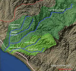
Devil Canyon Creek is a stream or arroyo, tributary to San Mateo Creek, in the Santa Margarita Mountains; all but its first and last part are within the Cleveland National Forest in San Diego County, California. Its source is at an altitude of 2440 feet on a flat private land in the Santa Margarita Mountains.[2] It flows southwestward before turning down into the canyon and the San Mateo Wilderness, then northward 2 miles before turning westward toward its confluence in San Mateo Canyon with San Mateo Creek at an elevation of 453 feet. The last half mile of the creek before this confluence is outside the National Forest boundary, and within the Camp Pendleton Marine Corps Base.[3] Devil Canyon has one named tributary, Cold Spring Canyon Creek, draining the Santa Margarita Mountains north of the Devil Canyon watershed; Cold Spring Canyon Creek enters it from the right about a mile and half above the confluence of Devil Canyon Creek with San Mateo Creek.[4][5]
^U.S. Geological Survey Geographic Names Information System: Devil Canyon Creek
^Devil Canyon Creek (source), USGS Map Name: Fallbrook, CA, Map Center: N33° 27' 38" W117° 22' 28" from topoquest.com accessed on 5/13/2013
^Devil Canyon, California (mouth), USGS Map Name: Margarita Peak, CA Map Center: N33° 28' 24" W117° 27' 57", from topoquest.com accessed on 5/13/2013
^Devil Canyon, California (mouth), USGS Map Name: Margarita Peak, CA Map Center: N33° 28' 44" W117° 26' 30", from topoquest.com accessed on 5/13/2013
^Beatrice Dawson Wood, Gazetteer of Surface Waters of California, Pacific Coast Basins and Great Basin, U.S. Government Printing Office, Washington, 1913, p.67
and 24 Related for: Devil Canyon Creek information
DevilCanyonCreek is a stream or arroyo, tributary to San Mateo Creek, in the Santa Margarita Mountains; all but its first and last part are within the...
the San Bernardino Mountains of San Bernardino County, California. DevilCanyonCreek with its tributary East and West Forks, are a tributary of the Santa...
the United States. Glen Canyon starts where Narrow Canyon ends, at the confluence of the Colorado River and the Dirty Devil River. A small part of the...
in the Grand Canyon, which he named Bright Angel Creek. The outlaw Butch Cassidy and his gang used tributary canyons of the Dirty Devil, such as Robbers...
oxidized rocks and is visible from Zabriskie point and the Golden Canyon trail. Much of Salt Creek is usually dry at the surface and covered by a bright layer...
The Grand Canyon (Hopi: Öngtupqa, Yavapai: Wi:kaʼi:la, Navajo: Bidááʼ Haʼaztʼiʼ Tsékooh, Southern Paiute language: Paxa’uipi, Spanish: Gran Cañón or Gran...
to Quitchupah Creek or its tributaries, including East Spring Canyon, Water Hollow, and North Fork and flows through Convulsion Canyon. It begins at an...
0 – Badger Creek Rapid (5) – First significant rapid in Marble Canyon with a large pour over in the center right. Mile 11.4 – Soap Creek Rapid (5) Mile...
the place where the Devils River had its confluence with the creek at the mouth of Pecos Canyon was called the Head of Devil's River. At this point the...
Hells Canyon is a ten-mile-wide (16 km) canyon in the Western United States, located along the border of eastern Oregon, western Idaho, and a small section...
Glen Canyon National Recreation Area (shortened to Glen Canyon NRA or GCNRA) is a national recreation area and conservation unit of the United States...
downstream terminus is the confluence with the Dirty Devil River. The lower half of the canyon is submerged beneath Lake Powell when the lake is at its...
mainly by Muddy Creek, which eventually joins the Fremont River to become Dirty Devil River northeast of Hanksville, Utah. The Dirty Devil River flows southward...
stream-bed in Coyote Gulch Neon Canyon Spooky Gulch Peek-a-Boo Gulch Calf Creek Falls Devils Garden Geology of the Bryce Canyon area - to the west of the basin...
Willow River Price River White River Range Creek San Rafael River Dark Canyon Dirty Devil River Muddy Creek Fremont River Escalante River San Juan River...
Castlewood Canyon State Park Chatfield State Park Cherry Creek State Park Cheyenne Mountain State Park Crawford State Park (Colorado) Eldorado Canyon State...
Black Canyon of the Gunnison National Park is an American national park located in western Colorado and managed by the National Park Service. There are...
The Black Canyon of the Colorado is the canyon on the Colorado River where Hoover Dam was built. The canyon is located on the Colorado River at the state...
Glenwood Canyon is a rugged scenic 12.5 mi (20 km) canyon in western Colorado in the United States. Its walls climb as high as 1,300 feet (400 m) above...
boat access near Hells Canyon Dam on the south end of the trail. Access can also be gained via trails leading from Seven Devils Wilderness Area trail head...
known as the Devil's Chasm Fortress, the CanyonCreek Ruins, the Pueblo Canyon Ruins, the Cold Springs Canyon Ruins, and the Cooper Forks Canyon Ruins. Collectively...
was the devil. The creek's Spanish name was Arroyo del Monte Diablo. Americans later applied the name Mount Diablo to the peak, and the creek. Mount Diablo...
lodge inside Grand Canyon National Park in Arizona. It sits at the bottom of Grand Canyon, on the east side of Bright Angel Creek, a little over half...
 Global Information