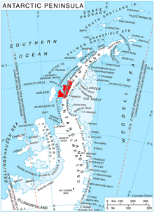
Darbel Bay (66°30′S65°55′W / 66.500°S 65.917°W / -66.500; -65.917) is a bay 25 nautical miles (50 km) wide, indenting the west coast of Graham Land between Stresher Peninsula and Pernik Peninsula. Entered southwest of Cape Bellue and northeast of Cape Rey. The glaciers Widmark Ice Piedmont, Cardell, Erskine, Hopkins, Drummond, Widdowson, McCance, Solun , and Škorpil feed the bay.
It was discovered and roughly charted by the French Antarctic Expedition, 1908–10, under Jean-Baptiste Charcot, who gave it the name Baie Marin Darbel. The bay was further charted in 1931 by Discovery Investigations personnel on the Discovery II, and by the British Graham Land Expedition, 1934–37, under John Rymill.[1]
^Cite error: The named reference gnis was invoked but never defined (see the help page).
DarbelBay (66°30′S 65°55′W / 66.500°S 65.917°W / -66.500; -65.917) is a bay 25 nautical miles (50 km) wide, indenting the west coast of Graham Land...
of Graham Land, Antarctica. It is situated at the northeast corner of DarbelBay, just north of the mouth of Cardell Glacier. Photographed by the Falkland...
peak rising to 852 m on the coast of DarbelBay on Loubet Coast in Graham Land, Antarctica. It surmounts DarbelBay to the west and its part Tlachene Cove...
southwest from Cape Bellue for 5 nautical miles (9 km) across the entrance to DarbelBay, off the west coast of Graham Land. They were charted in 1930 by Discovery...
65°41′W / 66.417°S 65.683°W / -66.417; -65.683) is a point within DarbelBay, lying 1.5 nautical miles (2.8 km) west of Shanty Point on the west coast...
The Kidd Islands are a small group of islands within DarbelBay, lying just south of the Darbel Islands off the west coast of Graham Land, Antarctica....
draining the north slopes of Roygos Ridge and flowing northwestwards into DarbelBay between Shanty Point and Panther Cliff, on the west coast of Graham Land...
northern height rising to 1644 and southern one to 2009 m at the head of DarbelBay on Loubet Coast in Graham Land, Antarctica. It surmounts McCance Glacier...
Sokol’ \'nos so-'kol\) is the narrow hilly point projecting 1.9 km into DarbelBay on Loubet Coast in Graham Land, Antarctica. It is formed by an offshoot...
is one of the few features on the plateau that is readily visible from DarbelBay. It was named by the UK Antarctic Place-Names Committee in 1960 for Sir...
north and east slopes, and surmounts Widdowson Glacier to the southwest, DarbelBay to the northwest, and Drummond Glacier to the northeast and east. The...
indenting for 3.6 km Loubet Coast on the Antarctic Peninsula. It is part of DarbelBay, entered southwest of Kudelin Point and northeast of Gostilya Point. The...
west side of Osikovo Ridge, Kladnitsa Peak and Rubner Peak and enters DarbelBay. The glacier was photographed by Hunting Aerosurveys Ltd in 1955–57, and...
Loubet Coast of Graham Land, Antarctica. It is identifiable from both DarbelBay and Lallemand Fjord. The peak was mapped from air photos taken by the...
Antarctic Peninsula. It is bounded by Holtedahl Bay to the northeast, Auvert Bay to the northwest and DarbelBay to the southwest. Its west extremity Cape Bellue...
Loubet Coast on the west side of Antarctic Peninsula. It is bounded by DarbelBay to the northeast, Lallemand Fjord to the west and Crystal Sound to the...
Workman Rocks is a group of rocks in the northeast part of DarbelBay just westward of Panther Cliff on the southwest coast of Stresher Peninsula, Graham...
sharp ridge separating McCance and Widdowson Glaciers, just south of DarbelBay on the northeast coast of Pernik Peninsula, Loubet Coast in Graham Land...
Erskine Glacier and flowing westwards into the head of Tlachene Cove in DarbelBay on the west coast of Graham Land, Antarctica. It was photographed by Hunting...
65°38′W / 66.417°S 65.633°W / -66.417; -65.633) is a small point within DarbelBay, lying close west of the mouth of Cardell Glacier on the west coast of...
-66.600; -66.450) is a dark rocky cape between the southwest side of DarbelBay and the northeast side of Lallemand Fjord, on the west coast of Graham...
65°51′W / 66.483°S 65.850°W / -66.483; -65.850) are islands lying in DarbelBay southeast of the Kidd Islands, off the west coast of Graham Land, Antarctica...
The name is descriptive of the feature when seen from Crystal Sound and DarbelBay. Owlshead Peak on USGS website Owlshead Peak on AADC website Owlshead...
southeast-northwest direction, 3.2 km wide and rising to 1247 m on the east coast of DarbelBay, Loubet Coast in Graham Land, Antarctica. It has rounded top and steep...
43222°W / -66.60167; -65.43222, which is 14.95 km east of Gostilya Point on DarbelBay, 5.67 km south of Mount Bain, 7.7 km west of Stefan Karadzha Peak and...
km southeast of Rubner Peak, 14 km south-southeast of Sokol Point on DarbelBay, 9.63 km southwest of the nearest of Zilva Peaks, and 12.1 km north of...
miles (30 km) long on the west coast of Graham Land, flowing west into DarbelBay to the north of Hopkins Glacier. It was first surveyed by the Falkland...
 Global Information