Greater Western Sydney, Northern Sydney, Inner West, St George
Area
• Total
2,750 km2 (1,060 sq mi)
Rivers
Hawkesbury River, Nepean River, Parramatta River, Georges River, Woronora River
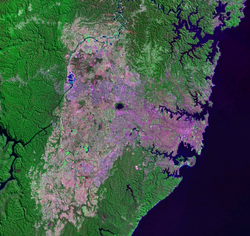
The Cumberland Plain, also known as Cumberland Basin,[2] is a relatively flat region lying to the west of Sydney CBD in New South Wales, Australia. An IBRA biogeographic region, Cumberland Basin is the preferred physiographic and geological term for the low-lying plain of the Permian-Triassic Sydney Basin found between Sydney and the Blue Mountains, and it is a structural sub-basin of the Sydney Basin.[3]
The Cumberland Plain has an area of roughly 2,750 square kilometres (1,060 sq mi), which lies on Triassic shales and sandstones. Shaping the geography of Sydney, it extends from 10 kilometres (6.2 mi) north of Windsor in the north, to Picton in the south; and from the Nepean-Hawkesbury River in the west almost to Sydney City, and includes parts of the Inner West and Northern Suburbs in the east. Much of the Sydney metropolitan area is located on the Plain. The Hornsby Plateau is located to the north and is dissected by steep valleys.[4]
The plain takes its name from Cumberland County, in which it is situated, one of the cadastral land divisions of New South Wales. The name Cumberland was conferred on the County by Governor Arthur Phillip in honour of Ernest Augustus, Duke of Cumberland.[1] Being the most populous region in Australia, the Cumberland Plain is one of the fastest-growing areas of the country in terms of population and it is home to a variety of Australian animal species, which are observable in the urban environments.[5]
^ ab"Cumberland". Geographical Names Register (GNR) of NSW. Geographical Names Board of New South Wales. Retrieved 4 August 2013.
^"Age and origin of the Cumberland (Inner Sydney) Basin of southeast Australia". Taylor & Francis. 2020. Retrieved 5 December 2023.
^Carter, Lewis (2011). Tectonic Control of Cenozoic Deposition in the Cumberland Basin, Penrith/Hawkesbury Region, New South Wales (Bachelor of Science (Honours) thesis). School of Earth & Environmental Sciences, University of Wollongong.
^"Sydney Basin". Office of Environment & Heritage. 2014. Retrieved 12 July 2014.
^Cooke, J.; Willis, T.; Groves, R. (2005). "Impacts of woody weeds on Cumberland Plain Woodland biodiversity". In Pellow, B.; Morris, C.; Bedward, M.; Hill, S.; Sanders, J.; Clark, J. (eds.). The ecology and management of Cumberland Plain habitats: a symposium. Campbelltown: University of Western Sydney. p. 7.
The CumberlandPlain, also known as Cumberland Basin, is a relatively flat region lying to the west of Sydney CBD in New South Wales, Australia. An IBRA...
The CumberlandPlain Woodland, also known as CumberlandPlain Bushland and Western Sydney woodland, is a grassy woodland community found predominantly...
Alluvial plain Atlantic Plain Coastal plains of Chile CumberlandPlain, Australia Israeli coastal plain Mississippi embayment North European Plain "Coastal...
predominant vegetation community in Sydney is the CumberlandPlain Woodland in Western Sydney (CumberlandPlain), followed by the Sydney Turpentine-Ironbark...
the more fertile lands around Parramatta, Windsor and Camden on the CumberlandPlain. By 1804, the colony was self-sufficient in food. Phillip had been...
the Great Dividing Range. Sydney sprawls over two major regions: the CumberlandPlain, a relatively flat region lying to the west of Sydney Harbour, and...
Granville. The line takes its name from the CumberlandPlain on which much of Western Sydney was built. Cumberland Line history Pre-2013 route (Blacktown to...
working class area of Greater Western Sydney. The region lies in the CumberlandPlain. There are a number of different boundaries and definitions for Sydney's...
000 trees in the parkland to rejuvenate the critically endangered CumberlandPlain Woodland community that once predominated the Sydney region. The Parklands...
of vegetation on Wianamatta Shale remaining on the CumberlandPlain, notably the CumberlandPlain Grey Box/ Ironbark Woodland (listed as an endangered...
region also largely contains remnants of critically endangered native CumberlandPlain Bushland and World Heritage-listed areas of the Blue Mountains. The...
the most predominant biome in the Sydney region, mainly occur in the CumberlandPlain west of Sydney CBD, which generally feature eucalyptus trees that are...
Parramatta Council is situated between the City of Ryde and Cumberland, where the CumberlandPlain meets the Hornsby Plateau, approximately 25 kilometres (16 mi)...
length of Cumberland Highway is designated part of route A28. The name of the highway is derived from the CumberlandPlain and Cumberland County. The...
Cumberland local government area. The bushland contains remnants of CumberlandPlain Woodland and is approximately 3.5 hectares (8.6 acres). Before opening...
South Wales in Western Sydney, Australia. A remnant bushland of the CumberlandPlain Woodland, it mainly features native vegetation. The reserve is so-named...
Sydney Parklands, a park system, and situated within the heart of the CumberlandPlain Woodland, the regional park features several picnic areas, recreational...
 Global Information