Curve along which a 3-D surface is at equal elevation
This article is about lines of equal value in maps and diagrams. For more meanings of the word "contour", see Contour (disambiguation).
The bottom part of the diagram shows some contour lines with a straight line running through the location of the maximum value. The curve at the top represents the values along that straight line.A three-dimensional surface, whose contour graph is below.A two-dimensional contour graph of the three-dimensional surface in the above picture.
A contour line (also isoline, isopleth, isoquant or isarithm) of a function of two variables is a curve along which the function has a constant value, so that the curve joins points of equal value.[1][2] It is a plane section of the three-dimensional graph of the function parallel to the -plane. More generally, a contour line for a function of two variables is a curve connecting points where the function has the same particular value.[2]
In cartography, a contour line (often just called a "contour") joins points of equal elevation (height) above a given level, such as mean sea level.[3] A contour map is a map illustrated with contour lines, for example a topographic map, which thus shows valleys and hills, and the steepness or gentleness of slopes.[4] The contour interval of a contour map is the difference in elevation between successive contour lines.[5]
The gradient of the function is always perpendicular to the contour lines. When the lines are close together the magnitude of the gradient is large: the variation is steep. A level set is a generalization of a contour line for functions of any number of variables.
Contour lines are curved, straight or a mixture of both lines on a map describing the intersection of a real or hypothetical surface with one or more horizontal planes. The configuration of these contours allows map readers to infer the relative gradient of a parameter and estimate that parameter at specific places. Contour lines may be either traced on a visible three-dimensional model of the surface, as when a photogrammetrist viewing a stereo-model plots elevation contours, or interpolated from the estimated surface elevations, as when a computer program threads contours through a network of observation points of area centroids. In the latter case, the method of interpolation affects the reliability of individual isolines and their portrayal of slope, pits and peaks.[6]
^Courant, Richard, Herbert Robbins, and Ian Stewart. What Is Mathematics?: An Elementary Approach to Ideas and Methods. New York: Oxford University Press, 1996. p. 344.
^ abHughes-Hallett, Deborah; McCallum, William G.; Gleason, Andrew M. (2013). Calculus : Single and Multivariable (6 ed.). John wiley. ISBN 978-0470-88861-2.
^"Definition of contour line". Dictionary.com. Retrieved 2022-04-04.
^"Definition of CONTOUR MAP". Merriam-Webster. Retrieved 2022-04-04.
^Tracy, John C. Plane Surveying; A Text-Book and Pocket Manual. New York: J. Wiley & Sons, 1907. p. 337.
^Davis, John C., 1986, Statistics and data analysis in geology, Wiley ISBN 0-471-08079-9
A contourline (also isoline, isopleth, isoquant or isarithm) of a function of two variables is a curve along which the function has a constant value,...
Look up contour in Wiktionary, the free dictionary. Contour may refer to: Contour (linguistics), a phonetic sound Pitch contourContour (camera system)...
Contour bunding or contour farming or contour ploughing is the farming practice of plowing and/or planting across a slope following its elevation contour...
known as the Third Interchange Contour, the city adopted "Bolshaya koltsevaya liniya" as the official name of the line after a vote via the "Active Citizen"...
measures the height of a mountain or hill's summit relative to the lowest contourline encircling it but containing no higher summit within it. It is a measure...
quantity and the Greek word iso, meaning equal), in microeconomics, is a contourline drawn through the set of points at which the same quantity of output...
a linear function. Hence the contourline of a quadric is always a plane section (i.e. a conic section). The contourline of the surface f ( x , y , z...
map with isopleth or contour lines that indicate differing amounts of rainfall. Such a map can be thought of as a rainfall contour map. Many sophisticated...
generates contours for a two-dimensional scalar field (rectangular array of individual numerical values). A similar method can be used to contour 2D triangle...
A contour canal is an artificially-dug navigable canal which closely follows the contourline of the land it traverses, in order to avoid costly engineering...
Contouring is a makeup technique that uses cosmetics to define, enhance and sculpt the structure of the face or other body parts, such as breasts. Contouring...
variables is two, a level set is called a level curve, also known as contourline or isoline; so a level curve is the set of all real-valued solutions...
the contourline. But knowing that a greatest slope vector is orthogonal to the contourline, one can readily deduce the direction of the contour lines...
touch a contourline of f, since by definition f does not change as we walk along its contour lines. This would mean that the tangents to the contour lines...
physical characteristics like the density and heat capacity of the water. A contourline of constant salinity is called an isohaline, or sometimes isohale. Salinity...
for contour integrals is the evaluation of integrals along the real line that are not readily found by using only real variable methods. Contour integration...
The Contours is one of the early American soul singing groups signed to Motown Records. The group is best known for its classic chart-topping 1962 hit...
Isoline may refer to: Contourline (line of constant elevation or depth, sometimes used to describe other lines of constant value) A line of constant value...
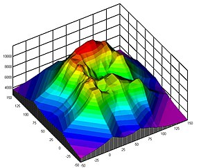
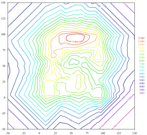
top of the contour map indicates a fault line. This fault line is between the blue/green contour lines and the purple/red/yellow contour lines. The thin...
top of the contour map indicates a fault line. This fault line is between the blue/green contour lines and the purple/red/yellow contour lines. The thin...
of a talented master, the line that conveys contour can deliver an astonishing amount of visual delight. In a continuous-line drawing, the artist looks...
the profile of St. Lucia, for example, stands out smoothly from the contourline thanks to the contrast of the glow against the green background. Fra...
is a contourline of equal time, for instance, in geological layers, tree rings or wave fronts. An isochrone map or diagram shows such contours. In linguistics...
compiler using topographic map contour lines. The true elevation is between that shown and the elevation plus the contourline interval which is forty feet...
the top of the contour map indicates a fault. This fault line is between the blue/green contour lines and the purple/red/yellow contour lines. The thin...
 Global Information