Global Information Lookup Global Information

City Road information


City Road
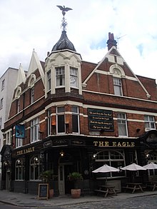
The Eagle pub on the City Road, mentioned in the Nursery rhyme Pop Goes the Weasel.[1]
City Road is located in London Borough of Islington
City Road
Location within Islington
Maintained byLondon Borough of Islington
LocationLondon, United Kingdom
Coordinates51°31′48″N 0°05′57″W / 51.53000°N 0.09917°W / 51.53000; -0.09917

City Road or The City Road is a road that runs through central London. The northwestern extremity of the road is at Angel where it forms a continuation of Pentonville Road. Pentonville Road itself is the modern name for the eastern part of London's first bypass, the New Road from Paddington to Islington, which was constructed in 1756. The City Road was built in 1761 as a continuation of that route to the City of London.

From Angel, City Road runs roughly south-east and downhill past the City Road Basin of Regent's Canal and Moorfields Eye Hospital, after which it bears closer to south, and has a junction with Old Street at a large roundabout. After Old Street, it continues south, continuing past Bunhill Fields, Wesley's Chapel and the Honourable Artillery Company, after which the road continues south as Finsbury Square, then Finsbury Pavement, then Moorgate—the latter beginning at the border with the City of London. These roads form a major entry point into the City of London, and were extended in 1846 through the City itself (as Princes Street and King William Street) to connect with London Bridge.

A map showing the City Road wards of Finsbury Metropolitan Borough as they appeared in 1952.

The part of the road north of Old Street is on the London Inner Ring Road and as such forms part of the boundary of the London congestion charge zone. The ringroad continues east along Old Street. Most of the road is in the London Borough of Islington, although the stretch from Wharf Road down to the Old Street roundabout is the border between Islington and Hackney, so the two sides are in different boroughs.

Nearby London Underground stations are Angel, Old Street and Moorgate. The disused City Road station was on City Road itself.

London Bus routes serving the length of City Road include 43, 205, 214, 394.

The City Road and The Eagle is mentioned in an additional verse written for the nursery rhyme Pop Goes the Weasel by 1856, when it was quoted in a performance at the Theatre Royal:

Up and down the City Road
In and out the Eagle
That's the way the money goes
Pop! goes the weasel.[2]

The rhyme appears on the wall of the Eagle.[1]

  1. ^ a b David Kemp (1992) The pleasures and treasures of Britain: a discerning traveller's companion p.158. Dundurn Press Ltd., 1992
  2. ^ I. Opie and P. Opie, The Singing Game (Oxford: Oxford University Press, 1985), pp. 216–18.

and 22 Related for: City Road information

Request time (Page generated in 0.9292 seconds.)

City Road

Last Update:

City Road or The City Road is a road that runs through central London. The northwestern extremity of the road is at Angel where it forms a continuation...

Word Count : 416

List of roads in Metro Manila

Last Update:

Philippines. Metro Manila's major road network comprises six circumferential roads and ten radial roads connecting the cities of Caloocan, Las Piñas, Makati...

Word Count : 2132

A roads in Zone 3 of the Great Britain numbering scheme

Last Update:

roads in zone 3 in Great Britain starting west of the A3 and south of the A4 (roads beginning with 3). Wikimedia Commons has media related to A roads...

Word Count : 56

Thiruvananthapuram

Last Update:

Road is the main arterial road in the city. Another important road is the Kowdiar Road, which is also known as the Royal Road, as it leads to the Kowdiar...

Word Count : 11238

Cities along the Silk Road

Last Update:

This articles lists cities located along the Silk Road. The Silk Road was a network of ancient trade routes which connected Europe with China, spanning...

Word Count : 660

City Road tube station

Last Update:

City Road is a disused London Underground station in Islington, central London. It was opened in 1901 as part of the City & South London Railway's extension...

Word Count : 606

London Inner Ring Road

Last Update:

northernmost point and moving clockwise, the roads defining the boundary are Pentonville Road, City Road, Old Street, Great Eastern Street, Commercial...

Word Count : 1183

Mandaue

Last Update:

broken down into: National road - 13.2 km (8.2 mi) City road - 57.1 km (35.5 mi) Barangay road - 63.4 km (39.4 mi) Road density is 5.31 km/km2 (8.55 mi/sq mi)...

Word Count : 2835

City and Guilds of London Institute

Last Update:

enough site within the City of London for their Central Institution, the CGLI occupied a building on land alongside Exhibition Road in South Kensington,...

Word Count : 3106

City status in the United Kingdom

Last Update:

as cities, notably in names associated with the settlements (e.g. 'City of Brechin and District' community council. and Brechin City F.C., City Road in...

Word Count : 10055

Gun Hill Road

Last Update:

Gun Hill Road or Gunhill Road may refer to: Gun Hill Road (road), a major thoroughfare in the New York City borough of The Bronx Gun Hill Road (film),...

Word Count : 117

List of roads in Dubai

Last Update:

and minor inter-city and intra-city roads. The network of highways and roads in Dubai, United Arab Emirates are managed by the Roads and Transport Authority...

Word Count : 78

City Road Cemetery

Last Update:

-1.44000 The City Road Cemetery is a cemetery in the City of Sheffield, England that opened in May 1881 and was originally Intake Road Cemetery. Covering...

Word Count : 568

Islington

Last Update:

the tunnel and north of the City Road was once dominated by much warehousing and industry surrounding the large City Road Basin and Wenlock Basin. Those...

Word Count : 4039

Automotive city

Last Update:

exclusive use (road infrastructure), had become synonymous with formulations of large North American and Australian cities. The label 'automotive city' has been...

Word Count : 2463

Road

Last Update:

on Road Traffic defines a road as the entire surface of any way or street open to public traffic. In urban areas roads may diverge through a city or village...

Word Count : 8157

Pentonville Road

Last Update:

Pentonville Road is a road in Central London that runs west to east from Kings Cross to City Road at The Angel, Islington. The road is part of the London...

Word Count : 2121

Kowloon Walled City

Last Update:

Walled City Park started the following month. The area where the walled city once stood is now Kowloon Walled City Park, adjacent to Carpenter Road Park...

Word Count : 6354

Highfield Road

Last Update:

Highfield Road was a football stadium in the city of Coventry, England. It was the home ground for Coventry City for 106 years. It was built in 1899 in...

Word Count : 599

Las Vegas Boulevard

Last Update:

south, the road meets Nellis Air Force Base on the east side and the Las Vegas Motor Speedway on the west side. As the road enters the city of North Las...

Word Count : 1163

Frontage road

Last Update:

A frontage road (also known as an access road, outer road, service road, feeder road, or parallel road) is a local road running parallel to a higher-speed...

Word Count : 5728

Ring road

Last Update:

a series of connected roads encircling a town, city or country. The most common purpose of a ring road is to assist in reducing traffic volumes in the...

Word Count : 4412

PDF Search Engine © AllGlobal.net