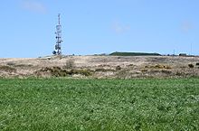
The telecommunications mast on Carnmenellis Hill. The mound to the right is a covered reservoir according to the OS map
Carnmenellis Hill (or just Carnmenellis) gives its name to the area of west Cornwall in England, between Redruth, Helston and Penryn. The hill itself is situated approximately three miles (5 km) south of Redruth.[1] It is one of five Marilyns in Cornwall; the others being Brown Willy (420 m), Kit Hill (334 m), Hensbarrow Beacon (312 m) and Watch Croft (252 m). The natural region of Carnmenellis has been designated as national character area 155 by Natural England.[2]
Penmarth, a nearby village, is sometimes referred to locally as Carnmenellis.[3]
The term 'Carnmenellis Granite' refers to the plateau of high ground in this area, one of five granite plutons in Cornwall that make up part of the Cornubian batholith (see also Geology of Cornwall).[4][5]
Carnmenellis was also the name of a former ecclesiastical parish created in 1846 from part of Wendron parish. Initially, the parish included the area which later became the parish of Pencoys. Today, most of the Carmenellis area is in Stithians civil parish.
The summit of Carnmenellis Hill is located at OS grid reference:grid reference SW 695 364) and is 252 metres (828 feet) above sea level.[1] A microwave transmitting and receiving tower on the summit is used for telephone and computer connections as well as other data and television and radio broadcasting links. It is maintained by BT.
A number of Iron Age fortifications surround the hill, but little archaeological research has been done on the site.
There is no public right of way across the summit, and the surrounding land is private farmland, though about half of the fields are Open Access land.
^ abOrdnance Survey: Landranger map sheet 203 Land's End ISBN 978-0-319-23148-7
^NCA 155: Carnmenellis - Key Facts & Data at www.naturalengland.org.uk. Accessed on 8 Sep 2013
^"GENUKI website; Carnmenellis".
^Ghosh, P. K. (1934). "The Carnmenellis Granite: its petrology, metamorphism and tectonics". Quarterly Journal of the Geological Society. 90 (1–4): 240–276. doi:10.1144/GSL.JGS.1934.090.01-04.09.
^Charoy, B. (1986). "The Genesis of the Cornubian Batholith (South-West England): the example of the Carnmenellis Pluton". Journal of Petrology. 27 (3): 571–604. doi:10.1093/petrology/27.3.571.
50°10′52″N 5°13′37″W / 50.181°N 5.227°W / 50.181; -5.227 Carnmenellis Hill (or just Carnmenellis) gives its name to the area of west Cornwall in England...
kilometres (1.2 mi) southeast of Redruth and is part of the Carnmenellis granite plateau, the 'Carnmenellis Granite', one of several granite plutons in Cornwall...
The Carnmenellis pluton and the smaller intrusion of Carn Brea appear to be part of a single intrusive body. The central part of the Carnmenellis outcrop...
of the Cornubian Batholith (South West England): the example of the Carnmenellis Pluton". Journal of Petrology; Oxford: OUP. Archived from the original...
descending altitude, these are Bodmin Moor, Hensbarrow north of St Austell, Carnmenellis to the south of Camborne, and the Penwith or Land's End peninsula. These...
and various buildings around the summit Carnmenellis 252 165 SW695364 Marilyn Hensbarrow Beacon Carnmenellis One of Cornwall's five Marilyns Summit trig...
Penwith and Kerrier (including the granite outcrops of Land's End and Carnmenellis) Tywarnhaile: St Agnes and the Carn Brea area Blackmore: the Hensbarrow...
and run by Arqiva. A microwave transmitting tower located on the hill, Carnmenellis, 2 miles (3.2 km) south of Redruth. It is owned and run by BT. Analogue...
Brown Willy (420 m), Kit Hill (334 m), Hensbarrow Beacon (312 m) and Carnmenellis (252 m). It is the highest point in West Penwith. Watch Croft is located...
United Kingdom. It is between Porkellis and Four Lanes near the hill of Carnmenellis. Cornwall portal Ordnance Survey (1961) One-inch Map of Great Britain;...
Marilyn hills in Cornwall, the four others are Watch Croft, Brown Willy, Carnmenellis and Hensbarrow Beacon. Kit Hill Country Park (which includes the hill...
however, is not the highest point in Redruth; it is beaten slightly by Carnmenellis, south west of the town centre. Redruth Rugby Football Club currently...
stone of a church for the Carnmenellis district was laid. Penmarth also had an Anglican Holy Trinity Church named Carnmenellis Church, which was built in...
Benson in 1881. Four Lanes and Pencoys are on the upland plateau of the Carnmenellis granite batholith. Four Lanes village centre is 220 metres (720 feet)...
reopened in May 2014. The site lies in the valley of the River Cober on the Carnmenellis granite outcrop. The river valley was once extremely rich in tin ore...
town council. Camborne-Redruth is on the northern side of the Carn Brea/Carnmenellis granite upland which slopes northwards to the sea. The two towns are...
ran from 1977 until 1994, and saw a Hot Dry Rock experiment drilled in Carnmenellis granite of Cornwall. The project, which was never intended to produce...
tower was added in the 15th century. The former ecclesiastical parish of Carnmenellis is now merged with Stithians parish. The church has a large two manual...
1994, a hot dry rock geothermal energy experiment was conducted in the Carnmenellis granite of Cornwall. During that experiment, three geothermal wells with...
completed by the end of the year. It was a chapel of ease in the parish of Carnmenellis, closing in the 1970s and is now used as the village hall. Porkellis...
the civil parish of Wendron. Calvadnack is south-west of the hill of Carnmenellis. In the centre of the moor are the remains of an Iron Age settlement...
Bodmin Moor Watch Croft, Penwith Hensbarrow Beacon, St Austell Downs Carnmenellis, between Redruth, Helston and Penryn Hobb's Hill, Bodmin Moor There are...
town of Helston and what are now the parishes of Carnmenellis and Pencoys. The parish of Carnmenellis was created in 1846; Helston in 1848; and Pencoys...
 Global Information