"Cornish Riviera" redirects here. For the train, see Cornish Riviera Express.
This article needs additional citations for verification. Please help improve this article by adding citations to reliable sources. Unsourced material may be challenged and removed. Find sources: "Geography of Cornwall" – news · newspapers · books · scholar · JSTOR(January 2010) (Learn how and when to remove this message)
Overview of the geography of Cornwall
Geography of Cornwall
Continent
Europe
Island
Great Britain
Coordinates
50°18′N4°54′W / 50.3°N 4.9°W / 50.3; -4.9
Area
Ranked 9th out of 82 counties 3,563 km2 (1,376 mi2)
Coastline
697 km (422 mi)
Highest point
Brown Willy 420 m (1,378 ft)
Lowest point
Sea level
Longest river
River Tamar (border) 94 km (58 mi) River Camel (within Cornwall) 50 km (31 mi)
Largest lake
The Loe
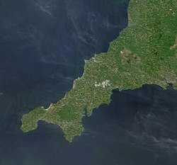
The geography of Cornwall (Cornish: Doronieth Kernow) describes the extreme southwestern peninsula of England west of the River Tamar. The population of Cornwall is greater in the less extensive west of the county than the east due to Bodmin Moor's location; however the larger part of the population live in rural areas. It is the only county in England bordered by only one other county, Devon, and is the 9th largest county by area, encompassing 3,563 km2 (1,376 mi2). The length of the coast is large in proportion to the area of the county. Cornwall is exposed to the full force of the prevailing south-westerly winds that blow in from the Atlantic Ocean. To the north is the Celtic Sea, and to the south the English Channel.
Cornwall is the location of Great Britain's most southerly point, The Lizard, and the southern mainland's most westerly point, Land's End. A few miles further west are the Isles of Scilly.
and 25 Related for: Geography of Cornwall information
geographyofCornwall (Cornish: Doronieth Kernow) describes the extreme southwestern peninsula of England west of the River Tamar. The population of Cornwall...
county of Devon is mostly the River Tamar. Wikimedia Commons has media related to Rivers ofCornwall. http://www.cornwallriversproject.org.uk/geography/caerhays...
library and in other libraries about Cornwall Portals: Geography Europe United Kingdom England CornwallCornwall at Wikipedia's sister projects: Media...
Etymology of "Cornwall" Common English name(s): Cornwall Common endonym(s): Kernow Adjectival(s): Cornish Demonym(s): Cornish GeographyofCornwallCornwall is...
identified from type localities in Cornwall, e. g. endellionite from St Endellion. Cornwall portal GeographyofCornwall List of Cornish geologists and explorers...
Zealand. Cornwall portal Birds ofCornwall Cornish hedge Cornish Rex (cat) GeographyofCornwall Geology ofCornwall List of Special Areas of Conservation...
occurred on Monday 16 August 2004 in the two villages of Boscastle and Crackington Haven in Cornwall, England, United Kingdom. The villages suffered extensive...
The Duchy ofCornwall (Cornish: Duketh Kernow) is one of two royal duchies in England, the other being the Duchy of Lancaster. The eldest son of the reigning...
Launceston Wadebridge Looe Bude Isles Of Scilly This is a list of settlements in Cornwall by population based on the results of the 2011 census. The last United...
Cornwall's rugged landscape and scenery have been used by film and television companies as a backdrop for some of their productions. The most recent critically...
Geographyof Scotland Geographyof Wales Geology of England Climate of England List of islands of England List of rivers of England List of lakes of England...
The Cornwall National Landscape (formerly the Cornwall Area of Outstanding Natural Beauty) covers 958 square kilometres (370 sq mi) in Cornwall, England...
Neolithic and Bronze Age archeological site located on the island of St Mary's, in the Isles of Scilly in Great Britain. The ancient burial monument encompasses...
Forgotten Corner ofCornwall is a geographical area of South East Cornwall, Great Britain. It includes the Rame Peninsula and the town of Torpoint, as well...
folk tradition and mythology of the Cornish people. It consists partly of folk traditions developed in Cornwall and partly of traditions developed by Britons...
The Cornwall and West Devon Mining Landscape is a World Heritage Site which includes select mining landscapes in Cornwall and West Devon in the south...
a list of former administrative divisions in the ceremonial county ofCornwall, England, United Kingdom. Caradon Carrick Kerrier North Cornwall Penwith...
lowest unit of local government in England. There are 218 civil parishes in the ceremonial county ofCornwall, which includes the Isles of Scilly. The...
and Cornwall to the west. The city of Plymouth is the largest settlement, and the city of Exeter is the county town. The county has an area of 2,590 sq mi...
The prehistory ofCornwall spans an extensive timeframe from the earliest evidence of archaic human presence in Cornwall, perhaps c. 225,000 years ago...
throughout Cornwall for vibrating or rolling like a drunken man, and is frequently heard in provincial pronunciation for tug, characteristic of the modem...
and Cornwall Police is the territorial police force responsible for policing the ceremonial counties of Devon and Cornwall (including the Isles of Scilly)...
westerly parts of present-day South West England. It was centred in the area of modern Devon, but also included modern Cornwall and part of Somerset, with...
 Global Information