"Skyline Boulevard" redirects here. For the other highway known as Skyline Boulevard, see California State Route 269.
State Route 35
Skyline Boulevard
SR 35 highlighted in red
Route information
Maintained by Caltrans
Length
54.056 mi[1] (86.995 km)
The length of SR 35 is broken into pieces and do not reflect overlaps.[2]
Tourist routes
Skyline Boulevard from the Santa Cruz–Santa Clara County line to SR 92[3]
Major junctions
South end
SR 17 near Redwood Estates
Major intersections
SR 84 in Woodside
SR 92 near San Mateo
I-280 from near Hillsborough to San Bruno
SR 1 in Daly City
North end
SR 1 in San Francisco
Location
Country
United States
State
California
Counties
Santa Clara, Santa Cruz, San Mateo, San Francisco
Highway system
State highways in California
Interstate
US
State
Scenic
History
Pre‑1964
Unconstructed
Deleted
Freeways
← SR 34
→ SR 36
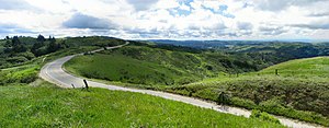
State Route 35 (SR 35), generally known as Skyline Boulevard for most of its length, is a mostly two-lane state highway in the U.S. state of California. It runs along the ridge of the Santa Cruz Mountains from the high point of State Route 17 near Lexington Reservoir in Santa Clara County to State Route 1 just south of Daly City in San Mateo County, where it crosses SR 1 and loops around Lake Merced to become Sloat Boulevard in San Francisco. SR 35 then continues along Sloat Boulevard until it reaches its terminus when it meets SR 1 again at 19th Avenue.
Because of its high elevation and location, it is one of the few places on the southern portion of the San Francisco Peninsula from which the San Francisco Bay and the Pacific Ocean are both visible at the same time. It also provides scenic views of the Silicon Valley metropolitan area.
It was originally designated State Route 5 (SR 5), but this had to be changed with the creation of Interstate 5 (I-5) in 1964 to avoid confusion between the two roads.
Skyline Boulevard stretches through the Santa Cruz Mountains, here near Palo AltoSR 35 briefly becomes a divided highway west of Daly City.
^Cite error: The named reference trucklist was invoked but never defined (see the help page).
^This route is broken into pieces, and the length does not reflect the overlaps that would be required to make the route continuous.
^California Department of Transportation (August 2019). "Officially Designated State Scenic Highways and Historic Parkways" (XLSX). Sacramento: California Department of Transportation. Retrieved March 27, 2019.
and 26 Related for: California State Route 35 information
StateRoute35 (SR 35), generally known as Skyline Boulevard for most of its length, is a mostly two-lane state highway in the U.S. state of California...
Highway in the Greater Los Angeles urban area of Southern California. It runs from I-405 and StateRoute 22 (SR 22) in Seal Beach in Orange County to I-210 just...
StateRoute 1 (SR 1) is a major north–south state highway that runs along most of the Pacific coastline of the U.S. state of California. At 656 miles...
following state highways in the U.S. state of California are entirely or partially unconstructed; in other words, their routings have been defined by state law...
StateRoute 3 (SR 3) is a state highway in the U.S. state of California that serves Trinity and Siskiyou counties. It runs from SR 36 north along the...
Route 5 (1934), now part of Route35 This disambiguation page lists articles associated with the title CaliforniaStateRoute 5. If an internal link led...
StateRoute 91 (SR 91) is a major east–west state highway in the U.S. state of California that serves several regions of the Greater Los Angeles urban...
while the eastern segment is signed as StateRoute 210 (SR 210) to its eastern terminus at I-10. Under the California Streets and Highways Code, the entire...
StateRoute 9 (SR 9) is a rural and mountainous state highway in the U.S. state of California that travels 35 miles (56 km) from SR 1 in Santa Cruz to...
StateRoute 16 (SR 16) is a state highway in the northern region of the U.S. state of California that runs from Route 20 in Colusa County to Route 49 just...
StateRoute 99 (SR 99) is a north–south state highway in the U.S. state of California, stretching almost the entire length of the Central Valley. From...
StateRoute 138 (SR 138) is an east–west state highway in the U.S. state of California that generally follows the northern foothills of the San Gabriel...
StateRoute 60 (SR 60) is an east–west state highway in the U.S. state of California. It serves the cities and communities on the eastern side of the Los...
StateRoute 160 (SR 160) is a state highway in the U.S. state of California consisting of two sections. The longer, southern, section is a scenic highway...
StateRoute 55 (SR 55) is an 18-mile (30-km) long north–south state highway that passes through suburban Orange County in the U.S. state of California...
state highways in the U.S. state of California that have existed since the 1964 renumbering. It includes routes that were defined by the California State...
StateRoute 84 (SR 84) is a state highway in the U.S. state of California that consists of two unconnected segments, one in the San Francisco Bay Area...
StateRoute 17 (SR 17, locally known as Highway 17) is a state highway in the U.S. state of California that runs from StateRoute 1 in Santa Cruz to I-280...
StateRoute 71 (SR 71) is a 15-mile (24 km) state highway in the U.S. state of California. Serving Riverside, San Bernardino, and Los Angeles counties...
StateRoute 33 (SR 33) is a north–south state highway in the U.S. state of California. It runs north from U.S. Route 101 in Ventura through the Transverse...
StateRoute 24 (SR 24) is a heavily traveled east–west state highway in the U.S. state of California that serves the eastern side of the San Francisco...
StateRoute 190 (SR 190) is a state highway in the U.S. state of California that is split into two parts by the Sierra Nevada. The western portion begins...
StateRoute 57 (SR 57), also known as the Orange Freeway for most of its length, is a north–south state highway in the Greater Los Angeles Area of the...
StateRoute 140 (SR 140) is a state highway in the U.S. state of California, 102 miles (164 km) in length. It begins in the San Joaquin Valley at Interstate...
 Global Information