SR 140 is broken into pieces, and the length does not reflect the overlaps that would be required to make the route continuous.
Tourist routes
SR 140 between Mariposa and El Portal[2]
Major junctions
West end
I-5 near Gustine
Major intersections
SR 33 in Gustine
SR 165 near Stevinson
SR 59 / SR 99 in Merced
SR 49 in Mariposa
East end
Yosemite National Park
Location
Country
United States
State
California
Counties
Merced, Mariposa
Highway system
State highways in California
Interstate
US
State
Scenic
History
Pre‑1964
Unconstructed
Deleted
Freeways
← SR 139
→ SR 142
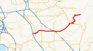
State Route 140 (SR 140) is a state highway in the U.S. state of California, 102 miles (164 km) in length. It begins in the San Joaquin Valley at Interstate 5 near Gustine, and runs east into Sierra Nevada, terminating in Yosemite National Park.
^Cite error: The named reference trucklist was invoked but never defined (see the help page).
^California Department of Transportation (August 2019). "Officially Designated State Scenic Highways and Historic Parkways" (XLSX). Sacramento: California Department of Transportation. Retrieved March 27, 2019.
and 26 Related for: California State Route 140 information
StateRoute140 (SR 140) is a state highway in the U.S. state of California, 102 miles (164 km) in length. It begins in the San Joaquin Valley at Interstate...
StateRoute 49 (SR 49) is a north–south state highway in the U.S. state of California that passes through many historic mining communities of the 1849...
StateRoute 33 (SR 33) is a north–south state highway in the U.S. state of California. It runs north from U.S. Route 101 in Ventura through the Transverse...
StateRoute 120 (SR 120) is a state highway in the central part of California, connecting the San Joaquin Valley with the Sierra Nevada, Yosemite National...
StateRoute 41 (SR 41) is a state highway in the U.S. State of California, connecting the Central Coast with the San Joaquin Valley and the Sierra Nevada...
StateRoute140 (SR 140) is a two-lane state highway in Humboldt County, Nevada. It serves a sparsely populated section of the state, connecting northwestern...
StateRoute 99 (SR 99) is a north–south state highway in the U.S. state of California, stretching almost the entire length of the Central Valley. From...
StateRoute 108 (SR 108) is a state highway in the U.S. state of California that runs from the Central Valley and across the Sierra Nevada via the Sonora...
StateRoute 12 (SR 12) is a state highway in the U.S. state of California that travels in an east–west direction from StateRoute 116 in Sebastopol in...
StateRoute 2 (SR 2) is a state highway in the U.S. state of California. It connects the Los Angeles Basin with the San Gabriel Mountains and the Victor...
StateRoute 165 (SR 165) is a rural north–south state highway in the U.S. state of California. It runs in the San Joaquin Valley from Interstate 5 south...
StateRoute 43 (SR 43) is a north–south state highway in the U.S. State of California, routed along the southern San Joaquin Valley between SR 119 southwest...
state highways in the U.S. state of California that have existed since the 1964 renumbering. It includes routes that were defined by the California State...
StateRoute 119 (SR 119), named as the Taft Highway along its entire length, is a state highway in the U.S. state of California that runs in an east–west...
part of StateRoute 17 (SR 17) together with the Nimitz Freeway. This section of I-80 has a top speed of 65 mph (105 km/h), unlike California's top speed...
Interstate Highway in the U.S. state of California, connecting San Bernardino, Riverside, and San Diego Counties. The route consists of the southernmost...
StateRoute 59 (SR 59) is a state highway in the U.S. state of California located entirely in Merced County. It connects StateRoute 152 near El Nido to...
There are 45 routes assigned to the "J" zone of the CaliforniaRoute Marker Program, which designates county routes in California. The "J" zone includes...
StateRoute 184 (SR 184), locally known as Weedpatch Highway, is a state highway in the U.S. state of California. Located in Kern County, it runs from...
California is a state in the Western United States, lying on the American Pacific Coast. It borders Oregon to the north, Nevada and Arizona to the east...
StateRoute 142 (SR 142), also known as Carbon Canyon Road for most of its length, is a state highway in the U.S. state of California that connects Brea...
StateRoute 190 (SR 190) is a state highway in the U.S. state of California that is split into two parts by the Sierra Nevada. The western portion begins...
StateRoute 223 (SR 223), locally known as Bear Mountain Boulevard, is a state highway in the U.S. state of California that runs west to east through the...
Pacific Coast, the other being U.S. Route 101 (US 101), which is primarily coastal. I-5 links the major California cities of San Diego, Santa Ana, Los...
 Global Information