Highway in California from the Mendocino coast to the Sacramento Valley
State Route 128
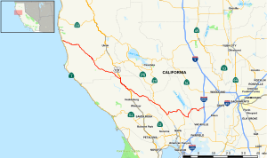
Map of western California with SR 128 highlighted in red
Route information
Maintained by Caltrans
Length
120.52 mi[1] (193.96 km)
Major junctions
West end
SR 1 near Albion
Major intersections
US 101 from Cloverdale to Geyserville
SR 29 from Calistoga to Rutherford
East end
I-505 in Winters
Location
Country
United States
State
California
Counties
Mendocino, Sonoma, Napa, Solano, Yolo
Highway system
State highways in California
Interstate
US
State
Scenic
History
Pre‑1964
Unconstructed
Deleted
Freeways
← SR 127
→ SR 129
State Route 128 (SR 128) is a state highway in the U.S. state of California, connecting the Mendocino coast to the Sacramento Valley, through the state's Wine Country. It runs from State Route 1 near Albion to Interstate 505 in Winters.
^Cite error: The named reference bridgelog was invoked but never defined (see the help page).
and 23 Related for: California State Route 128 information
StateRoute128 (SR 128) is a state highway in the U.S. state of California, connecting the Mendocino coast to the Sacramento Valley, through the state's...
Route128, known as the Yankee Division Highway, is an expressway in the U.S. state of Massachusetts maintained by the Highway Division of the Massachusetts...
StateRoute 1 (SR 1) is a major north–south state highway that runs along most of the Pacific coastline of the U.S. state of California. At 656 miles...
following state highways in the U.S. state of California are entirely or partially unconstructed; in other words, their routings have been defined by state law...
StateRoute 12 (SR 12) is a state highway in the U.S. state of California that travels in an east–west direction from StateRoute 116 in Sebastopol in...
counties. Its southern terminus is at StateRoute 37 at Sears Point, and its northern terminus is at StateRoute128 near Lake Berryessa. SR 121 passes through...
StateRoute 99 (SR 99) is a north–south state highway in the U.S. state of California, stretching almost the entire length of the Central Valley. From...
StateRoute 127 (SR 127) is a state highway in the U.S. state of California that connects Interstate 15 in Baker to Nevada StateRoute 373 at the Nevada...
state highways in the U.S. state of California that have existed since the 1964 renumbering. It includes routes that were defined by the California State...
Range from StateRoute128 near Boonville to U.S. Route 101 near Ukiah. The road begins in Boonville at an at-grade intersection with SR 128. The road...
while the eastern segment is signed as StateRoute 210 (SR 210) to its eastern terminus at I-10. Under the California Streets and Highways Code, the entire...
StateRoute 63 (SR 63) is a north–south state highway in the U.S. state of California in the Central Valley. It begins from near Tulare at Route 137, runs...
StateRoute 47 (SR 47) is a state highway in the U.S. state of California, connecting Terminal Island to the mainland in the Los Angeles area. From its...
part of StateRoute 17 (SR 17) together with the Nimitz Freeway. This section of I-80 has a top speed of 65 mph (105 km/h), unlike California's top speed...
StateRoute 41 (SR 41) is a state highway in the U.S. State of California, connecting the Central Coast with the San Joaquin Valley and the Sierra Nevada...
StateRoute 190 (SR 190) is a state highway in the U.S. state of California that is split into two parts by the Sierra Nevada. The western portion begins...
Pacific Coast, the other being U.S. Route 101 (US 101), which is primarily coastal. I-5 links the major California cities of San Diego, Santa Ana, Los...
then skirts the eastern city limits of Winters, intersecting with StateRoute128—the only exit in Winters. After leaving that city, the Interstate then...
StateRoute 180 (SR 180) is a state highway in the U.S. state of California. It runs through the heart of the San Joaquin Valley from StateRoute 33 in...
Nevada regions of California, Greater Sacramento is anchored by the state capital of Sacramento, the political center of California. Greater Sacramento...
There are 45 routes assigned to the "J" zone of the CaliforniaRoute Marker Program, which designates county routes in California. The "J" zone includes...
 Global Information