$88.4 million (First Powerhouse, Spillway, Lock and Fish structures) $664 million (Second Powerhouse)
Owner(s)
US Army Corps of Engineers (Operator) Bonneville Power Administration (Marketer)
Dam and spillways
Type of dam
Concrete gravity, run-of-the-river
Impounds
Columbia River
Height
171 ft (52 m)[1]
Length
2,690 ft (820 m)
Width (base)
132 ft (40 m) (Spillway)
Spillway type
Service, gate-controlled
Reservoir
Creates
Lake Bonneville
Total capacity
537,000 acre⋅ft (0.662 km3)
Catchment area
240,000 sq mi (620,000 km2)
Power Station
Turbines
20 and unit 0
Installed capacity
1242 MW[2]
Annual generation
4,466 GWh (2009)[3]
Bonneville Dam Historic District
U.S. National Register of Historic Places
U.S. National Historic Landmark District
Location
Bonneville, Oregon
Built
1934–1943
Architect
Claussen and Claussen
Architectural style
Colonial Revival
NRHP reference No.
86000727 (original) 86003598 (increase)
Significant dates
Added to NRHP
April 9, 1986
Boundary increase
March 26, 1987[4]
Designated NHLD
June 30, 1987[5]
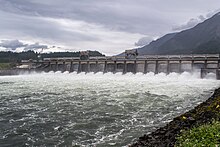
Bonneville Lock and Dam/ˈbɒnəvɪl/ consists of several run-of-the-river dam structures that together complete a span of the Columbia River between the U.S. states of Oregon and Washington at River Mile 146.1.[6] The dam is located 40 miles (64 km) east of Portland, Oregon, in the Columbia River Gorge. The primary functions of Bonneville Lock and Dam are electrical power generation and river navigation. The dam was built and is managed by the United States Army Corps of Engineers. At the time of its construction in the 1930s it was the largest water impoundment project of its type in the nation, able to withstand flooding on an unprecedented scale.[7] Electrical power generated at Bonneville is distributed by the Bonneville Power Administration. Bonneville Dam is named for Army Capt. Benjamin Bonneville, an early explorer credited with charting much of the Oregon Trail. The Bonneville Dam Historic District was designated a National Historic Landmark District in 1987.[5]
^"Bonneville Dam and Lake Bonneville".
^Cite error: The named reference BonnevilleBrochure was invoked but never defined (see the help page).
^"Bonneville". Carbon Monitoring for Action (CARMA). Retrieved August 13, 2016.
^"National Register Information System". National Register of Historic Places. National Park Service. January 23, 2007.
^ ab"Bonneville Dam Historic District". National Historic Landmark summary listing. National Park Service. Archived from the original on January 6, 2008. Retrieved November 18, 2007.
^"The Columbia River System Inside Story" (PDF). BPA.gov. pp. 14–15. Archived from the original (PDF) on May 27, 2010. Retrieved July 17, 2010.
^Cite error: The named reference nrhpinv2 was invoked but never defined (see the help page).
Bonneville Lock and Dam /ˈbɒnəvɪl/ consists of several run-of-the-river dam structures that together complete a span of the Columbia River between the...
BonnevilleDam located on the Columbia River and to construct facilities necessary to transmit that power. Congress has since designated Bonneville to...
Lake Bonneville was the largest Late Pleistocene paleolake in the Great Basin of western North America. It was a pluvial lake that formed in response to...
present site of BonnevilleDam. The most recent and significant is known as the Bonneville Slide, which formed a massive earthen dam, filling 3.5 miles...
lowered the level of the river by 5 feet (1.5 m) in the lake behind BonnevilleDam, which was searched with sonar technology but yielded no results. On...
marketed by the Bonneville Power Administration (BPA). It is part of an extensive system of dams on the Columbia and Snake Rivers. The Dalles Dam Visitor Center...
Benjamin Louis Eulalie de Bonneville (April 14, 1796 – June 12, 1878) was an American officer in the United States Army, fur trapper, and explorer in the...
The Bonneville flood was a catastrophic flooding event in the last ice age, which involved massive amounts of water inundating parts of southern Idaho...
salmon below fish ladders at BonnevilleDam and at other locations where fish must queue in order to pass through dams and locks that block their passage...
constructed to bypass the rapids. In the late 1930s, the construction of the BonnevilleDam led to the submerging of the rapids and most of the 1896 structures...
1928 Hoover Dam. The United States Army Corps of Engineers was also involved in hydroelectric development, completing the BonnevilleDam in 1937 and being...
expansion began in earnest following the 1933–1937 construction of the BonnevilleDam on the Columbia River. Hydroelectric power, food, and lumber provided...
be had in the BonnevilleDam area. There is a small non-Indian commercial gill net fishery several miles downstream from BonnevilleDam. There is also...
C. Boyle Dam – Klamath River Lake Billy Chinook & Round Butte Dam – Crooked, Deschutes, and Metolius rivers Lake Bonneville & BonnevilleDam – Columbia...
of Engineers. "The Bonneville Lock and Dam Fact Sheet" (PDF). Retrieved January 3, 2015. Columbia Basin Research. "BonnevilleDam - Hydroelectric Project...
Fort Peck Dam Grand Coulee Dam in Washington state Hoover Dam Mansfield Dam Pensacola Dam Tom Miller Dam Upper Mississippi River locks and dams Austin–Bergstrom...
and nearby settlements were submerged by the construction of The Dalles Dam. In 2019, there were calls by tribal leaders to restore the falls. The main...
round, with the exception of early summer, going as far upstream as BonnevilleDam. Though not as abundant as the California sea lion, there is still concern...
 Global Information