 Global Information
Binghamton metropolitan area information
Greater Binghamton | ||
|---|---|---|
Metropolitan Statistical Area | ||
| Binghamton, NY Metropolitan Statistical Area | ||
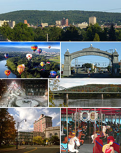 Clockwise from top: Downtown Binghamton skyline, the Endicott Johnson Square Deal Arch, the South Washington Street Bridge, the Ross Park Zoo carousel, Court Street Historic District, downtown in winter, and the Spiedie Fest and Balloon Rally | ||
|
Greater Binghamton Logo | ||
 Map of Binghamton, NY MSA
| ||
| Coordinates: 42°14′07″N 75°59′34″W / 42.235302°N 75.992765°W | ||
| Country | ||
| State | ||
| Largest city | Binghamton | |
| Population (2020)[1] | ||
| • Total | ||
| • Rank | 193rd in the U.S. | |
| Time zone | UTC−5 (EST) | |
| • Summer (DST) | UTC−4 (EDT) | |
The Binghamton Metropolitan Statistical Area, also called Greater Binghamton or the Triple Cities, is a region of southern Upstate New York in the Northeastern United States, anchored by Binghamton. The MSA encompasses Broome and Tioga counties,[2] which together had a population of 247,138 as of the 2020 census.[1] From 1963 to 1983, the MSA also included neighboring Susquehanna County in Pennsylvania,[3] part of which still falls in the Binghamton, NY–PA Urban Area.[4] In addition to these three counties, the greater region includes parts of Delaware and Chenango counties in New York; portions of Cortland and Otsego counties in New York and Wayne County, Pennsylvania are sometimes considered part of the region as well. Using the definition of a 30-mile radius from Binghamton, the population as of the 2010 census is 317,331.[5]
The Greater Binghamton name was adopted in the early 21st century to better identify the region with its most well-known city in efforts of marketing and external promotion.
The metropolitan area is located in the Southern Tier of New York State and lies on Pennsylvania's northern border, approximately 66 miles (110 km) south of Syracuse, New York.
- ^ a b "2020 Population and Housing State Data".
- ^ "Metropolitan Statistical Areas and Components". Office of Management and Budget. May 11, 2007. Archived from the original on May 26, 2007. Retrieved July 27, 2008.
- ^ "Metropolitan and Micropolitan - Historical Statistical Area Delineations". United States Census Bureau. Archived from the original on January 30, 2016. Retrieved March 10, 2016.
- ^ "2010 Urban Area Boundaries". New York State Department of Transportation. Retrieved March 10, 2016.
- ^ "2010 Demographics Report".