You can help expand this article with text translated from the corresponding article in German. (April 2019) Click [show] for important translation instructions.
View a machine-translated version of the German article.
Machine translation, like DeepL or Google Translate, is a useful starting point for translations, but translators must revise errors as necessary and confirm that the translation is accurate, rather than simply copy-pasting machine-translated text into the English Wikipedia.
Consider adding a topic to this template: there are already 9,120 articles in the main category, and specifying|topic= will aid in categorization.
Do not translate text that appears unreliable or low-quality. If possible, verify the text with references provided in the foreign-language article.
You must provide copyright attribution in the edit summary accompanying your translation by providing an interlanguage link to the source of your translation. A model attribution edit summary is Content in this edit is translated from the existing German Wikipedia article at [[:de:Nationalpark Bayerischer Wald]]; see its history for attribution.
You may also add the template {{Translated|de|Nationalpark Bayerischer Wald}} to the talk page.
For more guidance, see Wikipedia:Translation.
Region in Bavaria, Germany
Bavarian Forest
Effects of bark beetle in the Bavarian Forest
Highest point
Peak
Großer Arber (Great Arber)
Elevation
4,776 ft (1,456 m)
Naming
Native name
Bayerischer Wald(German)
Geography
Topography of the Bavarian Forest
Country
Germany
Region
Bavaria
Parent range
Central Uplands Bohemian Massif
Geology
Orogeny
Variscan
Type of rock
Metamorphic Gneiss and Granite rocks
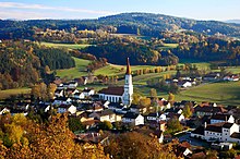
The village of Zell in the Bavarian ForestSummit of the Großer Arber with its summit cross and radome
The Bavarian Forest (German: Bayerischer Waldⓘ or Bayerwald; Bavarian: Boarischa Woid) is a wooded, low-mountain region in Bavaria, Germany that is about 100 kilometres long. It runs along the Czech border and is continued on the Czech side by the Bohemian Forest (Czech: Šumava). Most of the Bavarian Forest lies within the province of Lower Bavaria, but the northern part lies within Upper Palatinate. In the south it reaches the border with Upper Austria.
Geologically and geomorphologically, the Bavarian Forest is part of the Bohemian Forest - the highest of the truncated highlands of the Bohemian Massif. The area along the Czech border has been designated as the Bavarian Forest National Park (240 km2), established in 1970 as the first national park in Germany. Another 3,008 km2 has been designated as the Bavarian Forest Nature Park, established 1967, and another 1,738 km2 as the Upper Bavarian Forest Nature Park, established in 1965. The Bavarian Forest is a remnant of the Hercynian Forest that stretched across southern Germania in Roman times. It is the largest protected forest area in central Europe.[1]
The highest mountain in the region is the Großer Arber ("Great Arber", 1,456 m). The main river is the Regen, which is formed by the confluence of the White and Black Regen and flows out of the mountains towards the city of Regensburg.
^Bavarian Forest delights with nature's elegant artistry
The BavarianForest (German: Bayerischer Wald or Bayerwald; Bavarian: Boarischa Woid) is a wooded, low-mountain region in Bavaria, Germany that is about...
The BavarianForest National Park (German: Nationalpark Bayerischer Wald) is a national park in the Eastern BavarianForest immediately on Germany's border...
The Bavarian Alps (German: Bayerische Alpen) is a collective name for several mountain ranges of the Northern Limestone Alps within the German state of...
Bavarian side Zadní Bavorský les 'Rear BavarianForest', while in German, the Bohemian side is called Böhmerwald 'Bohemian Forest', and the Bavarian side...
The Anterior BavarianForest (German: Vorderer Bayerischer Wald), also variously called the Vorderer Forest, Vorderer Wald or Danube Hills, is part of...
Bavarian (German: Bairisch [ˈbaɪʁɪʃ] ; Bavarian: Boarisch or Boirisch), alternately Austro-Bavarian, is a major group of Upper German varieties spoken...
broadleaf forest ecosystem of Europe. Relict tracts of this once-continuous forest exist with many local names: the Black Forest, the Ardennes, the Bavarian Forest...
broadleaf forests ecoregion covers an area of 492,357 km2 (190,100 sq mi), including the Massif Central, Central German Uplands, Jura Mountains, Bavarian Plateau...
through the state: the Danube (Donau) and the Main. The BavarianForest and the Bohemian Forest form the vast majority of the frontier with the Czech Republic...
The BavarianForest Railway (Bayerische Waldbahn often just called the Waldbahn) (KBS 905) links the heart of the BavarianForest around Regen and Zwiesel...
The Ilz (German: [ɪlt͡s] ) is a river running through the BavarianForest, Germany. It is a left tributary of the Danube. During its 40 km (25 mi) length...
The Alpine Foreland, less commonly called the Bavarian Foreland, Bavarian Plateau or Bavarian Alpine Foreland (German: Bayerisches Alpenvorland), refers...
The BavarianForest Museum Village (German: Museumsdorf Bayerischer Wald) is an open air museum near Tittling on the southwestern shore of the Dreiburgensee...
The BavarianForest Nature Park (German: Naturpark Bayerischer Wald) covers an area north of the Danube as far as the border ridge with the Czech Republic...
 Global Information