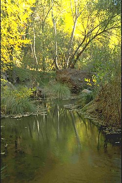
Aravaipa Creek is a drainage between three mountain ranges in southwest Graham County, Arizona – the Galiuro Mountains, the Santa Teresa Mountains and the Pinaleno Mountains. These mountains are part of the high altitude Madrean Sky Islands located in southern Arizona and New Mexico in the United States, and northern Sonora and Chihuahua states in Mexico.
Aravaipa Creek originates on the southeast flank of the Galiuro Mountains at Durkee Canyon and Blue Peak at 8,889 feet (2,709 m).[1] It then flows northwest through the narrow, fault-blocked Aravaipa Valley with the Pinaleno Mountains bordering the valley on the east and the Santa Teresa Mountains bordering on the northeast. On the west side of the valley, the creek follows the northeast and north perimeter of the Galiuro Mountains massif flowing northwest, west, and then southwest through and around the range's north end to meet the San Pedro River a few miles south of Dudleyville.
The town of Klondyke is located in the heart of the Aravaipa Valley about 35 miles west from Eden which is located on U.S. Route 70. There is also access to Klondyke via Arizona State Route 266 to Bonita (passing near Fort Grant) and thence on a gravel road north through the valley. Bonita may also be accessed by gravel road north from Willcox.
West of Klondyke in the Galiuro Mountains is the location of the well known Power's Cabin shootout. The former populated area of Aravaipa is located at the end of the Klondyke Road on the slopes of the Santa Teresa Mountains, north of Klondyke.
Aravaipa Canyon at the north end of the Galiuro Mountains contains the Aravaipa Canyon Wilderness. The creek goes northwest then southwest through the canyon and downstream about 9 miles (14 km) to meet the San Pedro River and Arizona State Route 77 between Dudleyville and Mammoth. Access to the eastern end of the wilderness is located north of Klondyke on the Klondyke Road.
AravaipaCreek is a drainage between three mountain ranges in southwest Graham County, Arizona – the Galiuro Mountains, the Santa Teresa Mountains and...
Aravaipa can refer to Aravaipa Canyon Wilderness, a wilderness area located in the U.S. state of Arizona AravaipaCreek, a major drainage between three...
Wash Rincon Creek Ciénega Creek Agua Verde Creek Davidson Canyon Mescal Arroyo Sonoita Creek Harshaw Creek San Pedro River AravaipaCreek Babocomari River...
AravaipaCreek is a tributary of the San Pedro River that runs through Aravaipa Canyon, including the BLM Aravaipa Canyon Wilderness area, in Graham County...
Oak Creek Canyon is a river gorge located in northern Arizona between the cities of Flagstaff and Sedona. The canyon is often described as a smaller cousin...
Havasu Creek is a stream in the U.S. state of Arizona associated with the Havasupai people. It is a tributary to the Colorado River, which it enters in...
from Aravaipa and Pinal bands soon came to the post to receive rations of beef and flour. That spring, Whitman created a refuge along AravaipaCreek, about...
Fossil Creek (Yavapai: Hakhavsuwa or Vialnyucha) is a perennial stream accessed by forest roads near the community of Camp Verde in the U.S. state of...
Mountains range. The more narrow canyon northeast is the Aravaipa Valley with AravaipaCreek. Mammoth, Arizona, northeast of Tucson and San Manuel, are...
What he did not realize was that the opening of Fort Breckinridge on AravaipaCreek and the San Pedro River in the Pinal homeland was forcing all raiders...
Sonoita Creek is a tributary stream of the Santa Cruz River in Santa Cruz County, Arizona. It originates near and takes its name from the abandoned Pima...
re-building a military post at the confluence of the San Pedro River and AravaipaCreek in Arizona Territory named the post Fort Stanford after the governor...
People”). Because of dialectical differences, the Pinaleño/Pinal and Arivaipa/Aravaipa bands of the San Carlos Apache pronounce the word as Innee or Nnēē:. The...
Fossil Creek Gila River Haigler Creek Horton Creek Negro Wash Salome Creek Salt River Tonto Creek White River Workman Creek Graham County AravaipaCreek Ash...
Retrieved 2012-03-16. "USGS Gage #09432000 on the Gila River Below Blue Creek, Near Virden, NM" (PDF). National Water Information System. U.S. Geological...
Mazatzal Wilderness. The Wild portion extends from there to the mouth of Red Creek, about 22 miles (35 km) further downstream. In 1986, a 6-mile (10 km) stretch...
Tonto Creek is a 72.5-mile-long (116.7 km) stream located in the Mogollon Rim area of the state of Arizona on the north edge of the Tonto National Forest...
permit is required for any overnight visit. The Paria is essentially a large creek and is not navigable. A 2004 study estimated that the Tropic Ditch, a historic...
site in the Aravaipa Canyon Preserve as of 2013.[unreliable source?] Travel in the canyon requires wading in AravaipaCreek. The Aravaipa Canyon Wilderness...
Kanab Creek (/kəˈnæb/ kə-NAB) is one of the many tributaries of the Colorado River. It begins in Kane County, Utah, just south of the watershed to the...
2009). "Mapping of Holocene River Alluvium along the San Pedro River AravaipaCreek and Babocomari River Southeastern Arizona: Babocomari River Geology...
 Global Information