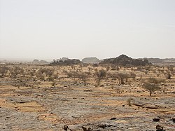
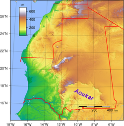
Aoukar or Erg Aoukar[1] (Arabic: عوكر) is a geological depression area of south eastern Mauritania. It is located between Kiffa and Néma, south of the Tagant Plateau. The region is also referred to as Hodh or El Hodh[5] (Arabic: الحوض, lit. 'the Basin').[3]
The Aoukar basin is a dry natural region of sand dunes and salt pans fringed by escarpments on its northern and eastern sides.
^Marco Stoppato, Alfredo Bini (2003), Deserts, p. 156
^Fāsī, Muḥammad & al. General History of Africa, Vol. III: Africa from the Seventh to the Eleventh Century, p. 130. UNESCO (Paris), 1988. Accessed 18 Apr 2014.
^ abBarth, Henry. Travels and Discoveries in North and Central Africa, being a Journal of an Expedition undertaken under the Auspices of H.B.M.'s Government, in the Years 1849–1855, Vol. 3, pp. 712 ff. Harper & Bros. (New York), 1859. Accessed 18 Apr 2014.
^Ould-Mey, Mohameden. Global Restructuring and Peripheral States: The Carrot and the Stick in Mauritania, p. 66. Rowman & Littlefield (Lanham), 1996. Accessed 18 Apr 2014.
^Also encountered as Hōdh, Ḥawḍ,[2]Hódh,[3] and al-Hodh.[4]
Aoukar or Erg Aoukar (Arabic: عوكر) is a geological depression area of south eastern Mauritania. It is located between Kiffa and Néma, south of the Tagant...
small oasis town in southeast Mauritania, located at the eastern end of the Aoukar basin. Oualata was important as a caravan city in the thirteenth and fourteenth...
The town is located in the southern area of the Aoukar, a former lake basin. Ayoun al Atrous was one of the stops in the 2007 Dakar Rally. Aoukar v t e...
been identified, is a southward prolongation of the Tagant Plateau. The Aoukar, the dry basin of a former lake lies beyond the southern escarpments of...
some 600 kilometres (370 mi) from the coast and at the western end of the Aoukar sand sea of southern Mauritania. Kiffa has a hot desert climate (Köppen...
between the Termit area of Niger, the Bodélé region of western Chad, and the Aoukar in Mauritania. Today there are over 600 addaxes in Europe, Yotvata Hai-Bar...
Central African Rift System White Nile rift Sedimentary basins Angola Basin Aoukar Blue Nile Basin Chad Basin Congo Basin Douala Basin El Djouf Karoo Basin...
Dune Rose in the city of Gao in northern Mali near the Niger River Erg Aoukar in southeastern Mauritania extending into Mali Erg Chech in southwestern...
(November 2010). Close Fit of Seven Towns in Ptolemy’s Geographica with Seven Aoukar Heritage Sites: Impacts on Early Arab Itineraries across Mauritania, Senegal...
east, Hodh El Gharbi and Assaba to the south and Brakna to the west. The Aoukar basin, which formerly gave name to the greater region, is located in the...
south and the Mauritanian regions of Gorgol and Guidimaka to the west. The Aoukar basin, which formerly gave name to the greater region, is located in the...
running from Boutilimit through 'Ayoûn el 'Atroûs to Néma, including the Aoukar basin. The area is mostly made up of steppes and savanna grasslands. Herds...
Tagant and Hodh El Gharbi to the west and Mali to the east and south. The Aoukar basin, which formerly gave name to a greater region, is located in the western...
defines the northern limit of the Hodh depression, near the former lake of Aoukar. The medieval trading settlement at Tichit is now a UNESCO World Heritage...
borders Mali, and a part of Malian territory protrudes into the region. The Aoukar basin, which formerly gave name to a greater region, is located in the northern...
(Arabic: بومديد) is a town and commune in Mauritania. It is located in the Aoukar basin, which formerly gave name to the greater region. It has a population...
Central African Rift System White Nile rift Sedimentary basins Angola Basin Aoukar Blue Nile Basin Chad Basin Congo Basin Douala Basin El Djouf Karoo Basin...
el Sendianeh Dahr el Sawan Dbayeh – Zouk al Khrab – Haret al Ballaneh – Aoukar Dekwaneh – Marroukouz – Daher al Hosein Dik El Mehdi Douar Fanar Ghabeh...
Dhar Tichitt, and Dhar Tagant form a semicircular shape around the Hodh/Aoukar Depression, which, prior to 4000 BCE, was an area with lakes of considerable...
Pro-Palestinian protestors took part in riots in the towns of Dbayeh and Aoukar. Businesses were vandalized and torched. October 19 – Dozens of rockets...
Central African Rift System White Nile rift Sedimentary basins Angola Basin Aoukar Blue Nile Basin Chad Basin Congo Basin Douala Basin El Djouf Karoo Basin...
Beit Awkar, Beit Okar, Beit Aoukar (Arabic: بيت عوكر) is a village in Zgharta District, in the Northern Governorate of Lebanon. It is located 15 km to...
Central African Rift System White Nile rift Sedimentary basins Angola Basin Aoukar Blue Nile Basin Chad Basin Congo Basin Douala Basin El Djouf Karoo Basin...
 Global Information