Middle-altitude Stratocumulus clouds arranged in groups or rolls. Has smaller clouds separate from each other
Precipitation
Virga only
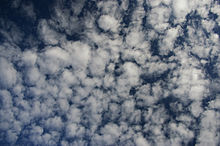
Altocumulus (from Latin altus 'high', and cumulus 'heaped')[1] is a middle-altitude cloud genus that belongs mainly to the stratocumuliform physical category, characterized by globular masses or rolls in layers or patches – the individual elements being larger and darker than those of cirrocumulus and smaller than those of stratocumulus.[2] However, if the layers become tufted in appearance due to increased airmass instability, then the altocumulus clouds become more purely cumuliform in structure. Like other cumuliform and stratocumuliform clouds, altocumulus signifies convection. A sheet of partially conjoined altocumulus perlucidus is sometimes found preceding a weakening warm front, where the altostratus is starting to fragment, resulting in patches of altocumulus perlucidus between the areas of altostratus. Altocumulus is also commonly found between the warm and cold fronts in a depression, although this is often hidden by lower clouds.
Towering altocumulus, known as altocumulus castellanus, frequently signals the development of thunderstorms later in the day, as it shows instability and convection in the middle levels of the troposphere, the area where towering cumulus clouds can turn into cumulonimbus.[3] It is therefore one of three warning clouds often recorded by the aviation industry, the other two being towering cumulus and cumulonimbus.[3] Altocumulus generally forms at about 2,000 to 6,100 m (6,600 to 20,000 ft) above ground level, a similar level to altostratus formations, and satellite photography has revealed that the two types of cloud can create formations that can stretch for thousands of square miles.[4] Extensive altocumulus formations, particularly if they take the form of undulatus are often referred to as altocumulus mackerel sky.
^"Altocumulus, International Cloud Atlas". Manual on the Observation of Clouds and Other Meteors. Vol. I. World Meteorological Organization. 1975. pp. 31–35. ISBN 92-63-10407-7. Retrieved 2014-08-26.
depression, although this is often hidden by lower clouds. Towering altocumulus, known as altocumulus castellanus, frequently signals the development of...
In meteorology, Altocumulus castellanus or Altocumulus castellatus (ACCAS) is a cloud type named for its tower-like projections that billow upwards from...
anvil top. There are also cumuliform clouds of limited convection that comprise stratocumulus (low-étage), altocumulus (middle-étage) and cirrocumulus (high-étage)...
Nacreous clouds that form in the lower stratosphere sometimes have lenticular shapes. There are three main types of lenticular clouds: altocumulus standing...
The altocumulus undulatus is a mid-level cloud (about 8,000–20,000 ft or 2,400–6,100 m), usually white or grey with layers or patches containing undulations...
Altocumulus lacunosus is a type of altocumuluscloud. The term lacunosus is from Latin, meaning "full of gaps". This type of cloud appears as holes present...
cirrocumulus, altocumulus, and stratocumulus. A newly recognized species of stratocumulus or altocumulus has been given the name volutus, a roll cloud that can...
cloud. Like altostratus, altocumulus are composed of a mixture of water droplets, supercooled water droplets, and ice crystals. Although altocumulus clouds...
Altocumulus stratiformis is the most common species of the Altocumulus genus of clouds. They tend to form broad layers of individual, cell-like clumps...
those in altocumulus, and the whole being at a lower height, usually below 2,000 metres (6,600 ft). Weak convective currents create shallow cloud layers...
Altocumulus volutus is a type of altocumuluscloud. This cloud type has the appearance of a single, small, horizontal, rolling line, it is relatively rare...
observed in altocumulus, cirrocumulus, lenticular, and cirrus clouds. They sometimes appear as bands parallel to the edge of the clouds. Iridescence...
A mackerel sky is a term for clouds made up of rows of cirrocumulus or altocumulusclouds displaying an undulating, rippling pattern similar in appearance...
August 2021. Altocumulus floccus (meaning tuft of wool, fluff, or nap of cloth...) "Altocumulus floccus". International Cloud Atlas. "Altocumulus floccus (Ac...
(stratocumulus, altocumulus, and cirrocumulus) clouds have the least in common with nimbostratus. Nimbostratus virga Cumulonimbus List of cloud types "cloud". Columbia...
of high cloud taking on a stratocumuli form structure as a result of high altitude convection. A high layer of white or light grey altocumulus of a particular...
formed from altocumulus castellanus or stratocumulus castellanus, which are forms of cumulus castellanus. The congestus species of cloud can only be found...
during rock slides). A convection cell is most notable in the formation of clouds with its release and transportation of energy. As air moves along the ground...
is highly unstable, cumulonimbus clouds producing thunderstorms commonly form along the front. Anvil cirrus clouds may spread a considerable distance...
each other. At formation, the cirrus floccus clouds are bright white and can be mistaken for altocumulusclouds; however, after a few minutes, the brightness...
are shown against a setting sun that intensely colors the dramatic altocumulusclouds. Church scholar John K. Howat describes the painting as "one of his...
this cloud as an altocumulus (perhaps altocumulus floccus), although the instability creating it is at a different level compared to an altocumulus. To...
Cumulus mediocris may form as a result of a partial transformation of altocumulus or stratocumulus. This genus and species type may also be the result...
front, the cirrus clouds spread out into cirrostratus, which then thicken and lower into altocumulus and altostratus. The next set of clouds are the rain-bearing...
 Global Information