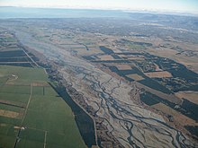
Floodplain (centre) within the alluvial plain of the Waimakariri River, New Zealand (part of the Canterbury Plains).A small, incised alluvial plain from Red Rock Canyon State Park (California).
An alluvial plain is a plain (a largely flat landform) created by the deposition of sediment over a long period of time by one or more rivers coming from highland regions, from which alluvial soil forms. A floodplain is part of the process, being the smaller area over which the rivers flood at a particular period of time, whereas the alluvial plain is the larger area representing the region over which the floodplains have shifted over geological time.
As the highlands erode due to weathering and water flow, the sediment from the hills is transported to the lower plain. Various creeks will carry the water further to a river, lake, bay, or ocean. As the sediments are deposited during flood conditions in the floodplain of a creek, the elevation of the floodplain will be raised. As this reduces the channel floodwater capacity, the creek will, over time, seek new, lower paths, forming a meander (a curving sinuous path). The leftover higher locations, typically natural levees at the margins of the flood channel, will themselves be eroded by lateral stream erosion and from local rainfall and possibly wind transport if the climate is arid and does not support soil-holding grasses. These processes, over geologic time, will form the plain, a region with little relief (local changes in elevation), yet with a constant but small slope.
The Glossary of Landform and Geologic Terms, maintained by the United States' National Cooperative Soil Survey (NCSS), defines an "alluvial plain" as "a large assemblage of fluvial landforms (braided streams, terraces, etc.,) that form low gradient, regional ramps along the flanks of mountains and extend great distances from their sources (e.g., High Plains of North America)" Use of "alluvial plain" as a general, informal term for a broad flood plain or a low-gradient delta is explicitly discouraged. The NCSS glossary instead suggests "flood plain".[1]
Alluvial plains have similar traits to a river delta; however, the river delta will flow into a larger body of water. Alluvial plains generally lack this.
^"Glossary of Landform and Geologic Terms" (PDF). National Soil Survey Handbook—Part 629. National Cooperative Soil Survey. April 2013. Retrieved 1 March 2023.
An alluvialplain is a plain (a largely flat landform) created by the deposition of sediment over a long period of time by one or more rivers coming from...
The Mississippi River AlluvialPlain is an alluvialplain created by the Mississippi River on which lie parts of seven U.S. states, from southern Louisiana...
occurs, for example, in the valley of the San Joaquin River, California. Alluvialplain Bay mud Braided stream Desert pavement Eluvium Hydraulic action Illuvium...
front onto a plain, the fans can combine to form a continuous apron. This is referred to as a bajada or piedmont alluvialplain. Alluvial fans usually...
Sichuan Plain (Chinese: 川西坝子; Sichuanese Pinyin: Cuan1xi1 Ba4zi3), is an alluvialplain located in the western part of the Sichuan Basin in southwestern China...
northern plains a lowland in the extreme southeast bootheel region of Missouri, part of the Atlantic Plain known as the Mississippi AlluvialPlain (areas...
Alluvialplain Atlantic Plain Coastal plains of Chile Cumberland Plain, Australia Israeli coastal plain Mississippi embayment North European Plain "Coastal...
modified by the deposits of the Yellow River. It is the largest alluvialplain of China. The plain is bordered to the north by the Yanshan Mountains, to the...
elevation than the alluvialplain or stream terrace, which are considered to be "lowlands". The term "bottomland" refers to low-lying alluvial land near a river...
high variation in microtopography and soil texture within floodplains. Alluvialplain – Region on which rivers have deposited sediment Flood-meadow – Land...
Sea Island, Floridian, East Gulf Coastal Plain, Mississippi AlluvialPlain, and the West Gulf Coastal Plain. The rocks in the province consist, for the...
Southeastern Plains within Louisiana 65f Southern Pine Plains and Hills 65p Southeastern Floodplains and Low Terraces Map of Mississippi AlluvialPlain within...
of loess. Perhaps the only truly flat region of Iowa, the Missouri AlluvialPlain contains areas of terraces, sloughs, and oxbows. Its valley trench is...
south, and Sanjiang Plain in the northeast. The Songnen plain was formed by the Songhua and alluvial soils from the Nen. The Liaohe plain, located in the...
The Punjab Plain is a large alluvialplain in Eastern Pakistan and Northwestern India. The plain includes the Pakistani province of Punjab and the Indian...
Mountains, Mississippi AlluvialPlain, Mississippi Valley Loess Plain, Ozark Highlands, Ouachita Mountains, and the South Central Plains. A 2010 United States...
The Messara Plain or simply Messara (Greek: Μεσσαρά) is an alluvialplain in southern Crete, stretching about 50 km west-to-east and 7 km north-to-south...
Armenian. Starting as early as the 6th millennium BC, the fertile alluvialplains between Iraq's Tigris and Euphrates Rivers, referred to as Mesopotamia...
Yangtze Plain (Chinese: 長江中下游平原/长江中下游平原; Wade-Giles: Ch'ang Chiang P'ing-yüan; Pinyin: Chang Jiang Pingyuan) is made up of a series of alluvialplains along...
Before the 2013 reorganisation, it was a town (belde). It is in the alluvialplain at the east of Göksu River. In the vicinity of Arkum, the Mediterranean...
Afghanistan, and northwestern India. The civilisation flourished both in the alluvialplain of the Indus River, which flows through the length of Pakistan, and...
Mesopotamia is a historical region of Mesopotamia. It is located in the alluvialplain of Iraq from the Hamrin Mountains to the Faw Peninsula near the Persian...
rivers), the northern highlands of Iraq, Lower Mesopotamia, and the alluvialplain extending from around Tikrit to the Persian Gulf. The mountains in the...
сирин ортоку намтала), also known as Central Yakut Plain or Vilyuy Lowland, is a low alluvialplain in Siberia, Russia. Administratively the territory...
Appalachian, Interior Low Plateaus, Southeastern Plains, Mississippi Valley Loess Plains, and Mississippi AlluvialPlain regions. Tennessee is the most biodiverse...
 Global Information