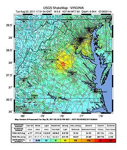
On August 23, 2011, a magnitude 5.8 earthquake hit the Piedmont region of the U.S. state of Virginia at 1:51:04 p.m. EDT. The epicenter, in Louisa County, was 38 mi (61 km) northwest of Richmond and 5 mi (8 km) south-southwest of the town of Mineral. It was an intraplate earthquake with a maximum perceived intensity of VIII (Severe) on the Mercalli intensity scale.[2] Several aftershocks, ranging up to 4.5 Mw in magnitude, occurred after the main tremor.
The quake was felt across more than a dozen U.S. states and in several Canadian provinces, and was felt by more people than any other quake in U.S. history.[5] No deaths and only minor injuries were reported. Minor and moderate damage to buildings was widespread and was estimated by one risk-modeling company at $200 million to $300 million, of which about $100 million was insured.[6][7]
The earthquake prompted research that revealed that the farthest landslide from the epicenter was 150 miles (240 km), by far the greatest landslide distance recorded from any other earthquake of similar magnitude. Previous studies of worldwide earthquakes indicated that landslides occurred no farther than 36 miles (58 km) from the epicenter of a magnitude 5.8 earthquake. The Virginia earthquake study suggested that the added information about East Coast earthquakes may prompt a revision of equations that predict ground shaking.
^ abc"Magnitude 5.8 – Virginia". United States Geological Survey. Archived from the original on August 24, 2011. Retrieved August 23, 2011.
^ ab"M 5.8 – 11 km SSW of Mineral, Virginia". earthquake.usgs.gov. USGS. Retrieved August 19, 2021.
^"Pager– M 5.8– Virginia". United States Geological Survey. Archived from the original on September 6, 2015. Retrieved August 23, 2011.
^Cite error: The named reference Jibson was invoked but never defined (see the help page).
^Ruane, Michael E.; Aratani, Lori (August 23, 2012). "Earthquake damage to Washington Monument was very rare occurrence". The Washington Post.
^Morello, Carol; Wiggins, Ovetta (August 24, 2011). "Region tallies earthquake damage, mostly uninsured". Washington Post.
^Estimate by the Oakland, California-based catastrophe modeling and risk assessment company EQECAT, which estimated further that only 5 percent of East Coast property owners have earthquake coverage. Hofmann, Mark A. (August 24, 2011). "Insured losses in East Coast earthquake less than $100M: EQECAT". Business Insurance.
and 23 Related for: 2011 Virginia earthquake information
On August 23, 2011, a magnitude 5.8 earthquake hit the Piedmont region of the U.S. state of Virginia at 1:51:04 p.m. EDT. The epicenter, in Louisa County...
the earthquake Seismicity of the New York City area List of earthquakes in the United States List of earthquakes in 2024 2011Virginiaearthquake – felt...
in Nevada List of earthquakes in Puerto Rico List of earthquakes in Texas List of earthquakes in Utah List of earthquakes in Virginia National Geophysical...
major earthquake occurred in Christchurch on Tuesday 22 February 2011 at 12:51 p.m. local time (23:51 UTC, 21 February). The Mw6.2 (ML6.3) earthquake struck...
other earthquakes of approximately magnitude 5 occurred in this region in 1737 and in the 1783 New Jersey earthquake. The 2011Virginiaearthquake, a 5...
strongest in state history. At 5.8 magnitude, this ties it with the 2011Virginiaearthquake, which was determined after it struck to be the most powerful quake...
This is a list of earthquakes in 2011. Only earthquakes of magnitude 6 or above are included, unless they result in damage and/or casualties, or are notable...
sciences portal List of earthquakes in 2011 List of earthquakes in the United States 2011Virginiaearthquake - Second M 5.0+ earthquake to hit the United States...
and earthquakes. In April 2013, a team of seismologists at the Georgia Institute of Technology re-examined data from the 2011Virginiaearthquake using...
The Virginia Seismic Zone in the U.S. state of Virginia covers about 8,000 square kilometers (3,100 sq mi) in the Piedmont province. Earthquakes in the...
history, and the largest to strike the East Coast since the 2011Virginiaearthquake. The earthquake occurred near the Piedmont region and Blue Ridge Mountains...
2011). "Virginiaearthquake largest recorded in commonwealth". The Daily Press. Retrieved May 22, 2020. Choi, Charles Q. (August 23, 2012). "2011 Virginia...
"Magnitude 5.8 - VIRGINIA; 2011 August 23 17:51:04 UTC". Earthquake Hazards Program. United States Geological Survey. August 23, 2011. Archived from the...
The 2011 Oklahoma earthquake was a 5.7 magnitude intraplate earthquake which occurred near Prague, Oklahoma on November 5 at 10:53 p.m. CDT (03:53 UTC...
The 2011 Sikkim earthquake (also known as the 2011 Himalayan earthquake) occurred with a moment magnitude of 6.9 and was centered within the Kanchenjunga...
that summer. On August 23, 2011, the Washington Monument sustained damage during the 5.8 magnitude 2011Virginiaearthquake; over 150 cracks were found...
The 2011 Tarlay earthquake occurred on 24 March in Shan State, Myanmar. The earthquake measured Mw 6.8 and had an epicenter northwest of the border between...
The 2011 Van earthquakes occurred in eastern Turkey near the city of Van. The first earthquake happened on 23 October at 13:41 local time. The shock had...
earthquakes. Levin posted a video onto YouTube the same day as 2011Virginiaearthquake in which he said, "The Talmud states, "You have shaken your male...
Services if she doesn't clean up her home. Note: The 2011Virginiaearthquake, a 5.8 earthquake that affected most of the Mid-Atlantic region, occurred...
Quantico Marine Base. Two of the blank panels were shattered by the 2011Virginiaearthquake. Inscribed on the Memorial are the names of service members who...
The June 2011 Christchurch earthquake was a shallow magnitude 6.0 Mw earthquake that occurred on 13 June 2011 at 14:20 NZST (02:20 UTC). It was centred...
The April 2011 Miyagi earthquake (2011年 宮城県沖地震, 2011-Nen Miyagi-ken-oki jishin) occurred off the coast of Miyagi Prefecture, approximately 66 kilometres...
 Global Information