This article needs to be updated. Please help update this article to reflect recent events or newly available information.(November 2010)
2009 Red River flood
Red River of the North in Fargo, March 28, 2009
Date
March 2009–April 2009
Location
North Dakota, Minnesota, Manitoba
Deaths
3[1]
Property damage
Unknown
Part of a series on the
Red River of the North
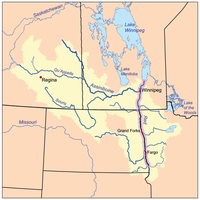
The Red River drainage basin, with the Red River highlighted
Major Floods
1950 flood
1997 flood (U.S. impacts)
2009 flood
2011 flood
Geology
Lake Agassiz
Red River Valley
Infrastructure
Red River Floodway
Related Topics
Canadian Heritage Rivers System
v
t
e
The 2009 Red River flood along the Red River of the North in North Dakota and Minnesota in the United States and Manitoba in Canada brought record flood levels to the Fargo-Moorhead area. The flood was a result of saturated and frozen ground, spring snowmelt exacerbated by additional rain and snow storms, and virtually flat terrain. Communities along the Red River prepared for more than a week as the U.S. National Weather Service continuously updated the predictions for the city of Fargo, North Dakota, with an increasingly higher projected river crest. Originally predicted to reach a level of near 43 feet (13 m) at Fargo by March 29, the river in fact crested at 40.84 feet (12.45 m) at 12:15 a.m. March 28,[2] and started a slow decline.[3] The river continued to rise to the north as the crest moved downstream.[4]
^Fargo’s Flood Fight Goes on as Red River Levels Fall. Bloomberg.com. March 29, 2009.
^"Fargo mayor: More levees will be breached". National Public Radio. March 29, 2009. Archived from the original on 31 March 2009. Retrieved 29 March 2009. (AP)
^"Daily and Hourly Changes in Level for the Red River at Fargo, ND".
^Real-time water data for Red River of the North at Pembina, ND, United States Geological Survey, March 29, 2009
and 27 Related for: 2009 Red River flood information
2009RedRiverflood along the RedRiver of the North in North Dakota and Minnesota in the United States and Manitoba in Canada brought record flood levels...
The RedRiverflood of 1997 was a major flood that occurred in April and May 1997 along the RedRiver of the North in Minnesota, North Dakota, and southern...
The 1950 RedRiverflood was a devastating flood that took place along the RedRiver in The Dakotas and Manitoba from April 15 to June 12, 1950. Damage...
The 2011 RedRiverflood took place along the RedRiver of the North in Manitoba in Canada and North Dakota and Minnesota in the United States beginning...
level of the Saint John river recorded. The 2009RedRiverflood was a major flood in March and April 2009 along the RedRiver of the North in North Dakota...
The RedRiver (French: rivière Rouge), also called the RedRiver of the North (French: rivière Rouge du Nord) to differentiate it from the RedRiver in...
The RedRiver Floodway (French: Canal de dérivation de la rivière Rouge) is an artificial flood control waterway in Western Canada. It is a 47 km (29 mi)...
The RedRiverflood of 1997 in the United States was a major flood that occurred in April 1997, along the RedRiver of the North in North Dakota and Minnesota...
of the Snake River. Unlike the Missoula Floods, which also occurred during the same period in the Pacific Northwest, the Bonneville flood happened only...
The 1897 RedRiverflood took place in April 1897, along the RedRiver resulting in significant damage to the city of Fargo, North Dakota. The conditions...
The Great Flood of 1993 (or Great Mississippi and Missouri RiversFlood of 1993) was a flood that occurred in the Midwestern United States, along the Mississippi...
The Great Mississippi Flood of 1927 was the most destructive riverflood in the history of the United States, with 27,000 square miles (70,000 km2) inundated...
2009RedRiverflood along the RedRiver of the North in North Dakota and Minnesota in the United States and Manitoba in Canada brought record flood levels...
The RedRiver Valley is a region in central North America that is drained by the RedRiver of the North; it is part of both Canada and the United States...
intense floods and increased flood risk. The types of floods include areal flooding, riverine flooding, coastal flooding and urban flooding. There is...
Mississippi River, the flood killed 2,208 people and accounted for US$17,000,000 (equivalent to about $580,000,000 in 2023) in damage. The American Red Cross...
A floodplain or flood plain or bottomlands is an area of land adjacent to a river. Floodplains stretch from the banks of a river channel to the base of...
Storofsen, Norway, flood of July 1789 RedRiver of the South flood of 1800. According to the Caddo tribe, a "great flood" moved down the river and reinforced...
The 2009 Great Britain and Ireland floods were a weather event that affected parts of Great Britain and Ireland throughout November and into December...
Columbia River Basalt Group. Large igneous provinces have been connected to five mass extinction events, and may be associated with bolide impacts. Flood basalts...
Yellow River Cantata Yellow Riverfloods Yellow River management Yellow River Map Yellow River Piano Concerto Yellow Sea RedRiver (disambiguation) Clapp,...
Mississippi River itself and its numerous natural tributaries and distributaries. The major tributaries are the Illinois, Missouri, Ohio and Redrivers. Given...
large cities on the river, including Nashville and Clarksville, both in Tennessee. The river system has been extensively altered for flood control. Major dams...
RiverFlood of 1973. The complex also contains a navigation lock and the Sidney A. Murray Jr. Hydroelectric Station. Before the 15th century, the Red...
River, the largest river in the region, measured water levels at a 500-year flood level. Rain began falling on the Atlanta area on September 15, 2009...
 Global Information