 Global Information
Yelizovsky District information
Yelizovsky District
Елизовский район | |
|---|---|
District | |
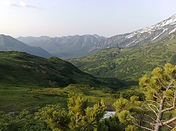 Road to Mutnovsky Glacier in Yelizovsky District | |
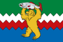 Flag  Coat of arms | |
 Location of Yelizovsky District in Kamchatka Krai | |
| Coordinates: 53°12′N 158°24′E / 53.200°N 158.400°E | |
| Country | Russia |
| Federal subject | Kamchatka Krai[1] |
| Established | November 17, 1949 |
| Administrative center | Yelizovo[1] |
| Area [2] | |
| • Total | 40,996.4 km2 (15,828.8 sq mi) |
| Population (2010 Census)[3] | |
| • Total | 24,566 |
| • Estimate (2018)[4] | 64,203 (+161.3%) |
| • Density | 0.60/km2 (1.6/sq mi) |
| • Urban | 6.5% |
| • Rural | 93.5% |
| Administrative structure | |
| • Inhabited localities[1] | 1 Urban-type settlements[5], 25 rural localities |
| Municipal structure | |
| • Municipally incorporated as | Yelizovsky Municipal District[6] |
| • Municipal divisions[6] | 2 urban settlements, 8 rural settlements |
| Time zone | UTC+12 (MSK+9 |
| OKTMO ID | 30607000 |
| 2010 Census | 24,566[3] |
|---|---|
| 2002 Census | 24,086[8] |
| 1989 Census | 28,720[9] |
| 1979 Census | 19,267[10] |
Yelizovsky District (Russian: Ели́зовский райо́н) is an administrative[1] and municipal[6] district (raion) of Kamchatka Krai, Russia, one of the eleven in the krai. It is located in the south of the krai. The area of the district is 40,996.4 square kilometers (15,828.8 sq mi).[2] Its administrative center is the town of Yelizovo (which is not administratively a part of the district).[1] As of the 2010 Census, the total population of the district was 24,566.[3]
- ^ a b c d e Law #46
- ^ a b Russian Federal Statistics Service. Kamchatka Krai (select Yelizovsky District in the drop-down menus) (in Russian)
- ^ a b c Russian Federal State Statistics Service (2011). Всероссийская перепись населения 2010 года. Том 1 [2010 All-Russian Population Census, vol. 1]. Всероссийская перепись населения 2010 года [2010 All-Russia Population Census] (in Russian). Federal State Statistics Service.
- ^ "26. Численность постоянного населения Российской Федерации по муниципальным образованиям на 1 января 2018 года". Federal State Statistics Service. Archived from the original on July 26, 2018. Retrieved January 23, 2019.
- ^ The count of urban-type settlements may include the work settlements, the resort settlements, the suburban (dacha) settlements, as well as urban-type settlements proper.
- ^ a b c Law #255
- ^ "Об исчислении времени". Официальный интернет-портал правовой информации (in Russian). June 3, 2011. Retrieved January 19, 2019.
- ^ Federal State Statistics Service (May 21, 2004). Численность населения России, субъектов Российской Федерации в составе федеральных округов, районов, городских поселений, сельских населённых пунктов – районных центров и сельских населённых пунктов с населением 3 тысячи и более человек [Population of Russia, Its Federal Districts, Federal Subjects, Districts, Urban Localities, Rural Localities—Administrative Centers, and Rural Localities with Population of Over 3,000] (XLS). Всероссийская перепись населения 2002 года [All-Russia Population Census of 2002] (in Russian).
- ^ Всесоюзная перепись населения 1989 г. Численность наличного населения союзных и автономных республик, автономных областей и округов, краёв, областей, районов, городских поселений и сёл-райцентров [All Union Population Census of 1989: Present Population of Union and Autonomous Republics, Autonomous Oblasts and Okrugs, Krais, Oblasts, Districts, Urban Settlements, and Villages Serving as District Administrative Centers]. Всесоюзная перепись населения 1989 года [All-Union Population Census of 1989] (in Russian). Институт демографии Национального исследовательского университета: Высшая школа экономики [Institute of Demography at the National Research University: Higher School of Economics]. 1989 – via Demoscope Weekly.
- ^ Всесоюзная перепись населения 1979 г. Национальный состав населения по регионам России [All Union Population Census of 1979. Ethnic composition of the population by regions of Russia] (XLS). Всесоюзная перепись населения 1979 года [All-Union Population Census of 1979] (in Russian). 1979 – via Demoscope Weekly (website of the Institute of Demographics of the State University—Higher School of Economics.