Global Information Lookup Global Information

Wyangala information


Wyangala
New South Wales
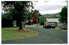
Wyangala village, looking towards St Vincent's Church, corner of Waugoola and Wirong Rds.
Wyangala is located in New South Wales
Wyangala
Wyangala
Coordinates33°57′S 148°59′E / 33.950°S 148.983°E / -33.950; 148.983
Population216 (SAL 2021)[1]
Postcode(s)2808
Elevation341 m (1,119 ft)[2]
Location
  • 320 km (199 mi) from Sydney
  • 40 km (25 mi) from Cowra
LGA(s)Cowra Shire
CountyKing County
State electorate(s)Cootamundra
Federal division(s)Hume
Mean max temp Mean min temp Annual rainfall
22.2 °C
72 °F
8.3 °C
47 °F
600 mm
23.6 in

Wyangala /ˈwæŋɡɑːlə/ is a small village in the Lachlan Valley, near the junction of the Abercrombie and Lachlan Rivers, just below the Wyangala Dam wall. It is in the South West Slopes of New South Wales, Australia, and about 320 km (200 mi) west of the state capital, Sydney. The name is also used for the surrounding rural locality, which includes the site of the former mining village of Mount McDonald.

The village was named after an indigenous word of unknown meaning, thought to be of Wiradjuri origin. The Wiradjuri were the original inhabitants of the Lachlan Valley, with campsites along river flats, on open land and by rivers. Their traditional way of life was altered, and perhaps lost, following the exploration of the valley by British explorers, John Oxley and George William Evans in 1815. White settlement followed in the 1830s, leading to violent clashes between the Wiradjuri and the settlers.

The present-day village was established in 1928, during the construction of Wyangala Dam. However, in the same area, there was a scattered pioneering settlement known as Wyangala Flats, which was established in the 1840s. This settlement was submerged under water following the completion of Wyangala Dam in 1935.

Although Wyangala grew substantially during periods of dam construction, the population dwindled in the subsequent years. This resulted in the removal of houses and the closure of most businesses, leaving Wyangala with a small primary school, a Catholic church, sports fields and parks, in addition to other facilities. There are no buildings of historical note, as the original purpose of the village was to solely provide utilitarian accommodation for the construction workers.

Attractions in the area include Lake Wyangala (used for power generation, water-sports and fishing activities), a nine-hole golf course, walking and mountain bike trails, and the 1.37 km (0.85 mi) long dam wall itself. Wyangala has a warm and temperate climate with a diverse range of native and exotic plants and animals, including threatened and endangered species. The flora, fauna and village residents occupy a hilly landscape dominated by granite, with large rock outcrops and boulders throughout the entire area.

  1. ^ Australian Bureau of Statistics (28 June 2022). "Wyangala (suburb and locality)". Australian Census 2021 QuickStats. Retrieved 28 June 2022. Edit this at Wikidata
  2. ^ "Elevation of 12 13 Winga Road Wyangala NSW 2808". elevationmap.net. Archived from the original on 17 May 2014. Retrieved 1 May 2014.

and 20 Related for: Wyangala information

Request time (Page generated in 0.5461 seconds.)

Wyangala

Last Update:

Wyangala /ˈwaɪæŋɡɑːlə/ is a small village in the Lachlan Valley, near the junction of the Abercrombie and Lachlan Rivers, just below the Wyangala Dam...

Word Count : 7380

Wyangala Dam

Last Update:

Wyangala Dam is a major gated rock fill with clay core embankment and gravity dam with eight radial gates and a concrete chute spillway across the Lachlan...

Word Count : 973

State parks of New South Wales

Last Update:

0012 (Wallaga Lake). Wyangala Waters State Park 33°57′55″S 149°00′04″E / 33.9652°S 149.0012°E / -33.9652; 149.0012 (Wyangala Waters), near Cowra....

Word Count : 649

Southern Electricity Supply

Last Update:

lines, running west to Griffith and east to Narrandera. PWD completed the Wyangala Dam on the Lachlan River in 1935, and added a hydro-electric power station...

Word Count : 3045

Lachlan River

Last Update:

073 ft) over its 1,440-kilometre (890 mi) course. The river is impounded by Wyangala Dam, near Cowra and Brewster Weir, located between Lake Cargelligo and...

Word Count : 1174

Reg Hailstone

Last Update:

food stuffs". He also saw great potential in elevating Wyangala 'National Park' (now Wyangala Waters State Park) to be an important tourist destination...

Word Count : 547

Condobolin

Last Update:

production having expanded with the damming of the Lachlan River in 1935 by the Wyangala Dam. Wheat, barley, canola, wool, sheep and cattle are produced in the...

Word Count : 1169

List of Australian place names of Aboriginal origin

Last Update:

Burrinjuck Corin Eucumbene Googong Jounama Pondage Pindari Tantangara Wyangala Arakwal Barool Baw Baw Bendidee Boonoo Boonoo Bouddi Budawang Burrowa Canunda...

Word Count : 1989

Cowra Shire

Last Update:

Darbys Falls, Gooloogong, Morongla, Noonbinna, Wattamondara, Woodstock, and Wyangala. The mayor of Cowra Shire Council is Ruth Fagan. Cowra Shire Council has...

Word Count : 248

List of power stations in New South Wales

Last Update:

Mulwala Canal 2.5 1 no Tumut 1 330 4 no Tumut 2 287 4 no Tumut 3 1500 6 yes Warragamba 50 1 no Williams River Dam (private) 7 1 no Wyangala 22.5 2 no...

Word Count : 448

Moama

Last Update:

Yellow Bog Landmarks Charles Sturt University Ettamogah Pub Hume Dam Hume Power Station Hume and Hovell Track Murrumbidgee Irrigation Area Wyangala Dam...

Word Count : 1385

Albury

Last Update:

Yellow Bog Landmarks Charles Sturt University Ettamogah Pub Hume Dam Hume Power Station Hume and Hovell Track Murrumbidgee Irrigation Area Wyangala Dam...

Word Count : 8510

Tocumwal

Last Update:

Yellow Bog Landmarks Charles Sturt University Ettamogah Pub Hume Dam Hume Power Station Hume and Hovell Track Murrumbidgee Irrigation Area Wyangala Dam...

Word Count : 1092

Deniliquin

Last Update:

Yellow Bog Landmarks Charles Sturt University Ettamogah Pub Hume Dam Hume Power Station Hume and Hovell Track Murrumbidgee Irrigation Area Wyangala Dam...

Word Count : 3780

Oolambeyan National Park

Last Update:

Yellow Bog Landmarks Charles Sturt University Ettamogah Pub Hume Dam Hume Power Station Hume and Hovell Track Murrumbidgee Irrigation Area Wyangala Dam...

Word Count : 190

Tumut

Last Update:

Yellow Bog Landmarks Charles Sturt University Ettamogah Pub Hume Dam Hume Power Station Hume and Hovell Track Murrumbidgee Irrigation Area Wyangala Dam...

Word Count : 1857

Cootamundra

Last Update:

Yellow Bog Landmarks Charles Sturt University Ettamogah Pub Hume Dam Hume Power Station Hume and Hovell Track Murrumbidgee Irrigation Area Wyangala Dam...

Word Count : 3453

Snowy Hydro

Last Update:

Tumut 2 Tumut 3 and Micro Hydro Warragamba Williams River Dam (private) Wyangala Solar generation Beryl Bomen Broken Hill Coleambally Darlington Point Finley...

Word Count : 1029

Conargo

Last Update:

Yellow Bog Landmarks Charles Sturt University Ettamogah Pub Hume Dam Hume Power Station Hume and Hovell Track Murrumbidgee Irrigation Area Wyangala Dam...

Word Count : 531

Floods in New South Wales

Last Update:

of the upper Lachlan River during autumn and winter 2016, resulted in Wyangala Dam increasing its storage capacity from 38 per cent to 90 per cent. By...

Word Count : 2962

PDF Search Engine © AllGlobal.net