Website Wingecarribee Reservoir at www.sca.nsw.gov.au
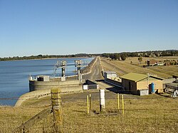
Wingecarribee Dam, completed in 1974 as part of the Shoalhaven Scheme, is an earth and rockfill embankment dam structure located on the Wingecarribee River about 15 kilometres (9.3 mi) southeast of Bowral in New South Wales, Australia. The embankment of 573 cubic metres (20,200 cu ft) is 19 metres (62 ft) high and 1,140 metres (3,740 ft) in length. At 100% capacity, the dam wall holds back approximately 25,875 megalitres (913.8×10^6 cu ft) and creates the impounded reservoir of Wingecarribee Reservoir that has a surface area of 625 hectares (1,540 acres), drawn from a catchment area of 40 square kilometres (15 sq mi). The spillway has a discharge capacity of 520 cubic metres per second (18,000 cu ft/s).[1] Wingecarribee Reservoir lost around 9,000 megalitres (320×10^6 cu ft) of storage capacity as a result of the inflow of peat from the Wingecarribee Swamp collapse in August 1998. The original storage capacity was 34,500 megalitres (1,220×10^6 cu ft).[2]
The dam has two outlets, the usual main spillway flowing into the Wingecarribee River which feeds the Warragamba Dam system, and an added extra sluice system known as the Glenquarry Cut which feeds into the Glenquarry Creek and then the Nepean River.
^"Register of Large Dams in Australia". Dams information. The Australian National Committee on Large Dams Incorporated. 2010. Archived from the original (Excel (requires download)) on 12 December 2013. Retrieved 3 May 2013.
^"Wingecarribee Reservoir". Water storage and supply report. Sydney Catchment Authority. Retrieved 9 March 2013.
WingecarribeeDam, completed in 1974 as part of the Shoalhaven Scheme, is an earth and rockfill embankment dam structure located on the Wingecarribee...
Wingecarribee Shire is the local government area of the Southern Highlands in the state of New South Wales, Australia. The Wingecarribee Shire is around...
(primary coordinates) GPX (secondary coordinates) Dams and reservoirs in Australia is a link page for any dam or reservoir in Australia. There are three key...
stored in three principal dams and their associated reservoirs: Tallowa Dam, Fitzroy Falls Dam and WingecarribeeDam. Wingecarribee River is a tributary of...
system as water from Tallowa Dam is pumped up to Wingecarribee Reservoir and then can be diverted to Warragamba Dam or Nepean Dam. The swamp has a history...
the Coxs, Kowmung, Nattai, Wingecarribee, Wollondilly, and Warragamba rivers, within the Hawkesbury-Nepean catchment. The dam created capacity for a reservoir...
000-metre (3,300 ft) Canal join the pumping station to the Wingecarribee Reservoir. The Fitzroy Falls Dam is connected to the Bendeela Pondage via the Bendeela...
located in the Southern Highlands of New South Wales, Australia, in Wingecarribee Shire. The town acts as the gateway to the Southern Highlands when coming...
collects water from the converged flows of the Coxs, Kowmung, Nattai, Wingecarribee, Wollondilly, and Warragamba rivers and their associated tributaries...
The Nepean Dam is a heritage-listed dam split across Avon in the Wingecarribee Shire and Bargo in the Wollondilly Shire, both in New South Wales, Australia...
770×10^6 cu ft) potable water supply and storage reservoir created by the Prospect Dam, across the Prospect Creek located in the Western Sydney suburb of Prospect...
Wyangala Dam is a major gated rock fill with clay core embankment and gravity dam with eight radial gates and a concrete chute spillway across the Lachlan...
The Avon Dam is a heritage-listed dam at Avon, in the New South Wales Southern Highlands, Australia. It is one of four dams and weirs in the catchment...
turns north-east to a point near Bullio, where it is joined by the Wingecarribee River. From here the Wollondilly River takes a wide detour to the north-west...
The Manly Dam is a heritage-listed dam near King Street, Manly Vale with a reservoir extending into Allambie Heights, both in the Northern Beaches Council...
Liverpool Offtake Reservoir (Liverpool Dam) is a small reservoir in Cecil Hills, New South Wales. Built along with the Upper Nepean Scheme it replaced...
of dams and weirs in the catchments of the Cataract, Cordeaux, Avon and Nepean rivers of New South Wales, Australia. The scheme includes four dams and...
The Pejar Dam is an earth and rock-filled embankment dam with an uncontrolled spillway across the Wollondilly River, located in the Southern Tablelands...
Burrinjuck Dam is a gated, concrete-walled hydro-electric gravity dam at Burrinjuck, in the South West Slopes region of New South Wales, Australia. It...
Austinmer Public School Austinmer Wollongong 1867 Avoca Public School Avoca Wingecarribee 1872 Balarang Public School Oak Flats Shellharbour 1968 Balgownie Public...
Oldbury Farm is a heritage-listed residence at Oldbury Road, Moss Vale, Wingecarribee Shire, New South Wales, Australia. It was built from 1822 to 1828. It...
The Stephens Creek Dam is an earth-filled embankment dam built on a rock foundation with an uncontrolled spillway across the Stephens Creek, located in...
Tareelaroi Tooma Toonumbar Tumut Two Tumut Pond Winburndale Windamere Wingecarribee Woodford Creek Wyangala Yellow Pinch Other water sources Sydney Desalination...
Winburndale Dam is a concrete gravity dam on the Winburndale Rivulet in New South Wales. Its height is 22 metres (72 ft) and holds back 1,700 megalitres...
The Cataract Dam is a heritage-listed dam in Cataract (formerly Appin), New South Wales, Australia, provides water to the Macarthur and Illawarra regions...
Pindari Dam is a minor concrete faced rockfill embankment dam with an ungated uncontrolled rock cut with concrete sill spillway across the Severn River...
foundations. Cordeaux Dam is located in three Council areas: Wollondilly, Wingecarribee and Wollongong. As at 21 January 2009, Cordeaux Dam was the second of...
Berrima Gaol's ten-metre-high outer walls were built close to the Wingecarribee River on the south western rear side. Located through the main gates...
 Global Information