 Global Information
Wijnjewoude information
Wijnjewoude
Wynjewâld | |
|---|---|
Village | |
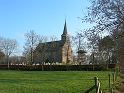 Wijnjewoude church | |
 Coat of arms | |
 Location in Opsterland municipality | |
 Wijnjewoude Location in the Netherlands  Wijnjewoude Wijnjewoude (Netherlands) | |
| Coordinates: 53°03′22″N 6°12′22″E / 53.05611°N 6.20611°E | |
| Country | |
| Province | |
| Municipality | |
| Area [1] | |
| • Total | 28.64 km2 (11.06 sq mi) |
| Elevation [2] | 4 m (13 ft) |
| Population (2021)[1] | |
| • Total | 2,055 |
| • Density | 72/km2 (190/sq mi) |
| Postal code | 9241[1] |
| Dialing code | 0516 |
| Website | Official |
Wijnjewoude (West Frisian: Wynjewâld) is a village in the municipality of Opsterland in the east of Friesland, the Netherlands. It had a population of around 2,025 in January 2017.[3] The villages of Duurswoude and Wijnjeterp were founded in the late Middle Ages next to one-another. After World War II the villages started to expand, and merged into a single village called Wijnjewoude in 1974.[4]
- ^ a b c "Kerncijfers wijken en buurten 2021". Central Bureau of Statistics. Retrieved 2 April 2022.
- ^ "Postcodetool for 9241EA". Actueel Hoogtebestand Nederland (in Dutch). Het Waterschapshuis. Retrieved 2 April 2022.
- ^ Kerncijfers wijken en buurten 2017 - CBS Statline
- ^ "Historie van Wijnjewoude". Friesland Wonderland (in Dutch). Retrieved 23 June 2020.