This article is about the village in Lancashire. For the hamlet in Cornwall, see Whitewell, Cornwall. For the townland in Ireland, see Whitewell, County Westmeath. For the village in Wales, see Whitewell, Wrexham.
Whitewell is a village within the civil parish of Bowland Forest Low and Ribble Valley borough of Lancashire, England. It is in the Forest of Bowland Area of Outstanding Natural Beauty. Historically, the village fell just within the boundaries of the West Riding of Yorkshire. It was transferred to Lancashire for administrative purposes on 1 April 1974, under the provisions of the Local Government Act 1972. It stands above a bend in the River Hodder.
The village comprises Upper and Lower Whitewell. Lower Whitewell is the site of St Michael's, a chapel of ease built in the late medieval period, certainly no later than 1400, which comes under the Lancashire parish of Whalley. The restaurant and hotel, The Inn at Whitewell, is also situated in Lower Whitewell.[1]
^"Welcome". Innatwhitewell.com. Retrieved 11 March 2019.
Whitewell is a village within the civil parish of Bowland Forest Low and Ribble Valley borough of Lancashire, England. It is in the Forest of Bowland...
54°39′14″N 5°55′48″W / 54.654°N 5.930°W / 54.654; -5.930 The Whitewell Road is an interface area in north Belfast and Newtownabbey, Northern Ireland...
Whitewell Hotel is an historic building in the English parish of Bowland Forest Low, Lancashire. It is Grade II listed, built in 1836, and is in sandstone...
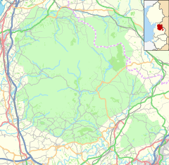
Whitewell Brook is a minor river in Lancashire, England. It is 4.34 miles (6.99 km) long and has a catchment area of 7.67 square miles (19.86 km2). The...
Cavehill and Whitewell Tramway operated steam powered, then horse drawn and finally electric tramway services between Cavehill and Whitewell in Belfast...
high-quality species-rich meadows. Caves in the area include Hell Hole, Whitewell Cave and Whitewell Pot. It is surrounded by the Yorkshire Dales and South Pennines...
Camelford and seven miles (11 km) northeast of Wadebridge. The hamlet of Whitewell lies to the west. The parish population at the 2011 census was 2628. An...
Carnmoney, Glengormley, Jordanstown, Monkstown, Whiteabbey, Whitehouse and Whitewell. Before this, the area fell under the jurisdiction of Belfast Rural District...
Whitewell & Stacksteads (3 seats) Party Candidate Votes % ±% Green Julie Adshead* 985 60.4 Green Bob Bauld 819 50.2 Green John Payne 764 46.8 Labour Jackie...
Research records (formerly PastScape). Retrieved 15 September 2013. Whitewell, J.B. (1970). Roman Lincolnshire. History of Lincolnshire. Vol. 2. Lincolnshire...
Hurst Green and Whitewell Party Candidate Votes % ±% Conservative Janet Elizabeth Alcock* 208 59.8 +2.7 Labour Andrew Niall MacFarlane 140 40.2 +8.4 Turnout...
Newtownabbey the Whitewell Road contains an interface area between the republican Whitewell and loyalist White City areas. The Whitewell area, as well as...
2A serving whitewell Road, Glengormley, Carnmoney Road and Prince Charles Way to Fairview Road. Route 2B serves the Abbeycentre, Whitewell Road, Glengormley...
Hareholme Healey and Whitworth Helmshore Irwell Longholme Stacksteads Whitewell Worsley Rossendale is part of the Rossendale and Darwen constituency....
Lancaster, acquired 6,000 acres (2,400 ha) of the forest, known as the Whitewell Estate, near Clitheroe; it was generally assumed that the Lordship of...
Sawley. Some parts of the Forest of Bowland attached to the Chapelry of Whitewell, were part of the Lancashire parish of Whalley in neighbouring Blackburnshire...
contained the wards of Ballyhenry, Glengormley, Mossgrove, Mossley and Whitewell. It was abolished for the 1985 local elections and replaced by the Antrim...
Church Accrington B6238 A681, Waterfoot A671, Deerplay Moor Passes through Whitewell Bottom, Lumb, Water, and joins the A671 for Burnley B6241 A583 in Ashton...
 Global Information