Territorial authority district in Northland, New Zealand
Whangarei District
Territorial authority district
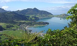
Mt Lion at the Whangarei Heads as viewed from Mt Manaia
Country
New Zealand
Region
Northland
District
Whangarei District Council
Wards
Māori Bream Bay Hikurangi-Coastal Mangakahia-Maungatapere Whangārei Heads Whangārei Urban
Local hapū
Ngāti Hine Ngāti Wai Patuharakeke Te Parawhau
Seat
Whangārei
Government
• Mayor
Vince Cocurullo[1]
• Deputy Mayor
Phil Halse [2]
• Territorial authority
Whangarei District Council
Area
[3]
• Total
2,855 km2 (1,102 sq mi)
• Land
2,712.13 km2 (1,047.16 sq mi)
Population
[4]
• Estimate
(June 2023)
101,900
Postcode(s)
Map of postcodes
Whangarei District is a territorial authority district in the Northland Region of New Zealand that is governed by the Whangarei District Council. The district is made up in area largely by rural land, and includes a fifth of the Northland Region. It extends southwards to the southern end of Bream Bay, northwards to Whangaruru and almost to the Bay of Islands, and westwards up the Mangakahia River valley past Pakotai and almost to Waipoua Forest. It includes the Hen and Chicken Islands and the Poor Knights Islands.
The principal urban area and district seat is the city of Whangārei. Other towns include Hūkerenui, Hikurangi, Titoki, Portland, Ruakākā and Waipu. The district population was 101,900 in June 2023.[4]
The district contains beaches such as Ngunguru, game fishing at Tutukaka, a variety of beaches along Whangārei Harbour, as well as Matakohe or Limestone Island in the Harbour, now subject to ecological restoration. The main airport for the district is Whangarei Airport.
^"Northland's longest serving politician named Whangārei Deputy Mayor". 16 September 2023.
^"Northland's longest serving politician named Whangārei Deputy Mayor". 16 September 2023.
^"Whangarei District Quarterly Review" (PDF). Statistics New Zealand. September 2007. p. 13. Archived from the original (PDF) on 4 June 2010.
^ ab"Subnational population estimates (RC, SA2), by age and sex, at 30 June 1996-2023 (2023 boundaries)". Statistics New Zealand. Retrieved 25 October 2023. (regional councils); "Subnational population estimates (TA, SA2), by age and sex, at 30 June 1996-2023 (2023 boundaries)". Statistics New Zealand. Retrieved 25 October 2023. (territorial authorities); "Subnational population estimates (urban rural), by age and sex, at 30 June 1996-2023 (2023 boundaries)". Statistics New Zealand. Retrieved 25 October 2023. (urban areas)
and 19 Related for: Whangarei District information
WhangareiDistrict is a territorial authority district in the Northland Region of New Zealand that is governed by the WhangareiDistrict Council. The district...
This is a list of lists of marae (Māori meeting grounds) in the Northland Region of New Zealand. In October 2020, the Government committed $9,287,603 from...
Whangārei Airport (IATA: WRE, ICAO: NZWR) is an airport 4 nautical miles (7.4 km; 4.6 mi) to the south east of Whangārei city, in the suburb of Onerahi...
currently 53 districts in New Zealand. The North Island comprises 34 districts. Far North District Kaipara DistrictWhangareiDistrict Hauraki District Matamata-Piako...
to become the Far North District. Whangarei City, Whangarei County, and Hikurangi Town Councils became the WhangareiDistrict, with Dargaville Borough...
the WhangareiDistrict and the Northland Region local government areas. The Greater Marsden Point Area extends from One Tree Point, within Whangārei Harbour...
Warkworth or Helensville. A map on the police station wall covers much of WhangareiDistrict, from southern Bream Bay north to Matapouri, and another map shown...
Centre with Wairau Māori Art Gallery is an art and cultural centre in Whangārei, New Zealand. It is the conception of artist and architect Friedensreich...
Council, Waitaki District Council, Far North District Council, and the WhangareiDistrict Council to add fluoride to their water supplies. These local authorities...
The Ahuroa River is a river in the Northland Region of the North Island of New Zealand. It is a tributary of the Waipu River which it joins close to the...
Hikurangi is a settlement in Northland, New Zealand. The city of Whangārei is 17 km (11 miles) to the south, and Kawakawa is 39 km (24 miles) northwest...
kilometres (7.5 mi) east of Bream Head and 40 kilometres (25 mi) south-east of Whangārei with a total area of 8.44 km2 (3.26 sq mi). Approximately 18,000 years...
Northern division. The board serves the Far North District, WhangareiDistrict and Kaipara District (which equates to the Northland Region), as defined...
Point Oil Refinery was a 96,000 BPD refinery located at Marsden Point, Whangarei, Northland, New Zealand. It was the only oil refinery in New Zealand,...
The Whangarei Harbour Marine Reserve is a protected area in the North Island of New Zealand. It was established in 2006 and measures 236.5 ha (584 acres)...
Marsden A was a 250 MW oil-fired power station near the Marsden Point Oil Refinery at Marsden Point, Ruakaka, Northland, New Zealand. It was built between...
 Global Information