Source: Bureau of Transportation Statistics,[1] Federal Aviation Administration[2]
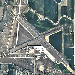
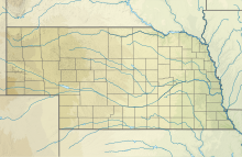
Western Nebraska Regional Airport (IATA: BFF, ICAO: KBFF, FAA LID: BFF) (William B. Heilig Field) is three miles east of Scottsbluff, in Scotts Bluff County, Nebraska.[2] The airport is owned by the Airport Authority of Scotts Bluff County[2] and is named after William B. Heilig. Known as "Scottsbluff's Mr. Aviation," he was a World War II United States Army Air Force primary flight instructor, a civil flight instructor, and manager of the city's airport.[3]
It sees one passenger airline, subsidized by the Essential Air Service program. In 2016, the airport had 4,262 passenger boardings (enplanements), a 17.15% decrease from the 5,144 enplanements in 2015.[4] The airport had 10,608 enplanements in calendar year 2008,[5] 9,221 in 2009 and 9,864 in 2010.[6]
The National Plan of Integrated Airport Systems for 2017–2021 categorized it as a non-primary commercial service airport.[7]
^"Scottsbluff, NE: Western Neb. Regional/William B. Heilig Field (BFF)". Bureau of Transportation Statistics. Retrieved November 26, 2021.
^ abcFAA Airport Form 5010 for BFF PDF. Federal Aviation Administration. Effective November 4, 2021.
^"William B. Heilig". Nebraska Department of Aeronautics.
^
"Enplanements for CY 2016" (PDF, 831 KB). Enplanements at All Airports (Primary, Non-primary Commercial Service, and General Aviation) by State and Airport, 6 October 2017. Federal Aviation Administration. October 6, 2017.
^
"Enplanements for CY 2008" (PDF, 1.0 MB). CY 2008 Passenger Boarding and All-Cargo Data. Federal Aviation Administration. December 18, 2009.
^
"Enplanements for CY 2010" (PDF, 189 KB). CY 2010 Passenger Boarding and All-Cargo Data. Federal Aviation Administration. October 4, 2011.
^
"2017–2021 NPIAS Report, Appendix A" (PDF, 3.48 MB). faa.gov. Federal Aviation Administration. September 30, 2016.
and 14 Related for: Western Nebraska Regional Airport information
is a list of airports in Nebraska (a U.S. state), grouped by type and sorted by location. It contains all public-use and military airports in the state...
Montana List of airports in Nebraska List of airports in Nevada List of airports in New Hampshire List of airports in New Jersey List of airports in New Mexico...
Rail station code), near Gwynedd, Wales WesternNebraskaRegionalAirport (IATA code), near Scottsbluff, Nebraska, United States Best friends forever, a...
Federal Regulations, Part 380. The first airport to enter this program was Manistee County Blacker Airport in 2012. Under the Community Flexibility Pilot...
Denver International Airport (IATA: DEN, ICAO: KDEN, FAA LID: DEN), locally known as DIA, is an international airport in the Western United States, primarily...
station), a passenger rail and bus station Fullerton Municipal Airport, a Regional Relief airport Fullerton Police Department, established in 1904 Fullerton...
Airfields in Nebraska, six are municipal airports (Ainsworth, Alliance, Scottsbluff, Lincoln, Kearney, Grand Island), four are owned by the Nebraska Department...
Washington. The airport is sometimes referred to as KCIA (King County International Airport), but it is not the airport identifier. The airport has scheduled...
series in the Ninja Warrior franchise Ainsworth RegionalAirport (IATA code: ANW), Ainsworth, Nebraska, USA Aviación Del Noroeste, S.A. de C.V. (ICAO code:...
(CDR / KCDR) in Chadron, Nebraska, approximately 30 miles (48 km) south. The nearest major airport is Rapid City RegionalAirport, in Rapid City, South Dakota...
to the north. It continues north past Kearney RegionalAirport before turning west where it meets Nebraska Highway 40 north of Kearney. Here, it turns north...
Midland School, North Branch, New Jersey, US Midland University, Fremont, Nebraska, US Midland (band), a country music group Midland (DJ), a London DJ Midland...
 Global Information