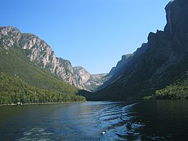
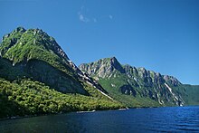
Western Brook Pond is a Canadian fjord or lake located in Gros Morne National Park on the west coast of the island of Newfoundland.[1] It is in the Long Range Mountains, the most northern section of the Appalachian Mountains.
Rock wallsEastern dead endRock walls
It is surrounded by steep rock walls 600 m (2,000 ft) high,[2] having been carved from the surrounding plateau by glaciers. After the glaciers melted, the land rebounded and the fjord was cut off from the sea. Salty water was eventually flushed from the fjord leaving it fresh. The catchment area is composed of igneous rock with relatively thin soil, so the waters feeding Western Brook Pond are low in nutrients and the lake is classified as ultraoligotrophic.[2] It is fed by Stag Brook at the extreme eastern end of the lake and by numerous waterfalls cascading from the plateau above. One of these, Pissing Mare Falls at 350 m (1,150 ft), is one of the highest in eastern North America.
The lake is accessible by a moderate-easy 3 km (1.9 mi) hiking trail over coastal bogs and low limestone ridges.[3] Two tour boats, one with a capacity of 70 passengers and the other 90 passengers, cruise the lake from June to mid-October.[4] The lake waters are pristine, having had very little impact from human activities. The tour boat operators had to undergo special certification to ensure that their operations would have minimal impact on the environment.[5]
In the early part of the 20th century, a part of the surrounding cliff broke off and fell into the lake, causing a 30 m (98 ft) tsunami.[6]
WesternBrookPond is a Canadian fjord or lake located in Gros Morne National Park on the west coast of the island of Newfoundland. It is in the Long Range...
within this Inlier. The western boundary of this inlier (along WesternBrookPond, St. Pauls Inlet, and south of Portl Creek Pond) consists of Devonian...
Canada. It is formed from Burnt Woods Brook, which plunges over the edge of Big Level Plateau into WesternBrookPond. At 343 m (1,125 ft) high, with an...
Nachvak Fiord, and Hebron Fiord, are in Labrador. While WesternBrookPond, Trout River Big Pond, and Bonne Bay in Gros Morne National Park are located...
Bridge BrookPond is located southeast of Mount Arab, New York. Fish species present in the lake are white sucker, brook trout, and black bullhead. There...
Blair Pond, which has public access from Mooney Street and Normandy Ave. There are multiuse paths or sidewalks on at least one side of the brook for the...
Fiord and South Fiord. Another freshwater "fjord" in a larger lake is WesternBrookPond, in Newfoundland's Gros Morne National Park; it is also often described...
A portion of the trail opened in 2006. The Great Northern Peninsula of Western Newfoundland contains the Highlands, the largest external basement massif...
Colman, John A and Paul J. Friesz. "Geohydrology and Limnology of Walden Pond, Concord, Massachusetts". USGS. Retrieved 2020-07-07. Quinn, Frank H. (1992)...
drain into the pond, including King Philip Brook, Queen Gutter Brook, and Blossom Brook, among others. The north end of North Watuppa Pond is crossed by...
North Pond tributaries include Sucker Brook and Clark Brook joining the overflow from East Pond, and Leech Brook, Bog Brook and Pattee Brook flowing...
John's represents the east coast, Gander the interior of the island, Corner Brook the west coast of the island and Wabush the interior of Labrador. The detailed...
Outflow from the pond travels through Bicknell Brook to Crystal Lake in Enfield, then north to the Mascoma River in West Canaan. Grafton Pond is located within...
and brook trout. Access via trail from West Flow Bay of Cranberry Lake on the south shore. No motors are allowed on Olmstead Pond. "Olmstead Pond". Geographic...
The brook begins at Cranberry Pond in the town of Croydon, New Hampshire, and flows north, through Stocker Pond, to a junction with Bog Brook in the...
Tributaries North Brook and South Brook flow into the eastern end of Upper Wilson Pond from Mountain Pond and Horseshoe Pond, respectively. The western end of Upper...
and crust as an example of plate tectonics, the park also includes WesternBrookPond, Lobster Cove, and Gros Morne mountain in the Long Range Mountains...
Cove (where it crosses the WesternBrook), and Gulls Marsh. The highway now passes Gros Morne National Park's WesternBrookPond trailhead before passing...
the towns of Grantham and Enfield. Water from Eastman Pond flows via Eastman Brook and Stocker Brook to the North Branch of the Sugar River, then the Sugar...
of Kings Pond, a manmade lake in southwest Ridgewood. Continuing north, past the tributary at Kings Pond, Goffle Brook splits into western and eastern...
the shoreline. The pond is located near Maine State Route 180. It is also not far from the community of Ellsworth, Maine. Middle Brook and a number of other...
Stream, thence into Millsfield PondBrook, and into Clear Stream. The west side of Kelsey drains into Phillips Brook, thence into the Upper Ammonoosuc...
Region Left-right from top: Boston skyline, Bass Harbor Head Light, WesternBrookPond, Montreal skyline, Fundy National Park, Mount Washington, Halifax...
western flank of First Watchung Mountain in North Haledon then merges with the brook before it reaches Oldham Pond. At Oldham Pond, Molly Ann Brook is...
Church Pond is a small lake located south of Stark. Church Pond is the source of the North Branch Grass River. Fish species present in the lake are brook trout...
 Global Information