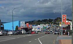
Wellsford (Māori: Whakapirau)[3] is a town on the Northland Peninsula in the northern North Island of New Zealand. It is the northernmost major settlement in the Auckland Region, and is 77 kilometres (48 mi) northwest of the Auckland CBD. It is a major regional centre, being located at the junction of State Highways 1 and 16, almost halfway between Auckland and the Northland city of Whangārei.
The eastern Kaipara Harbour has been settled by Māori since the 13th or 14th centuries, who utilised the inland forests and marine resources of the Kaipara Harbour. The area became home to the Ngāti Whātua collective Te Uri-o-Hau by the mid-17th century, with hapū including Ngāti Mauku, Ngāti Tahuhu and Ngāti Rongo being established from the descendants of Haumoewhārangi, and by strategic marriages with Te Kawerau hapū.
Wellsford was established by the Albertlanders in 1862, a group of Baptist tradespeople and farmers from the Birmingham area who settled the southern Oruawharo River, developing into a timber and kauri gum. By the early 20th century, the area developed into a regional centre for dairy farming, in part due to the opening of Wellsford railway station in 1909, linking the town to Auckland.
^Cite error: The named reference Area was invoked but never defined (see the help page).
^"Subnational population estimates (RC, SA2), by age and sex, at 30 June 1996-2023 (2023 boundaries)". Statistics New Zealand. Retrieved 25 October 2023. (regional councils); "Subnational population estimates (TA, SA2), by age and sex, at 30 June 1996-2023 (2023 boundaries)". Statistics New Zealand. Retrieved 25 October 2023. (territorial authorities); "Subnational population estimates (urban rural), by age and sex, at 30 June 1996-2023 (2023 boundaries)". Statistics New Zealand. Retrieved 25 October 2023. (urban areas)
^Rodney Local Board (May 2023). Wellsford Centennial Park Masterplan (PDF) (Report). Auckland Council. Retrieved 16 January 2024.
Wellsford (Māori: Whakapirau) is a town on the Northland Peninsula in the northern North Island of New Zealand. It is the northernmost major settlement...
being located in Ellerslie. They also have chapters in West Auckland, Wellsford, Northland and Wellington. They have a long criminal history, with more...
time, the company owned 22,000 apartments. In 1997, the company acquired Wellsford Residential Property Trust for $620 million in stock and the assumption...
containing the country's most populous city, Auckland, as well the towns of Wellsford, Warkworth, Helensville, the Hibiscus Coast, Pukekohe and Waiuku and their...
distillation plant was established by the Forests Commission Victoria at Wellsford State Forest near Bendigo in 1926. The Principal of the Victorian School...
The Wharehine River is a river in New Zealand. Located west of Wellsford, it is a tributary of the Oruawharo River. List of rivers of New Zealand "Place...
The Kaiwakawaka River is a river of New Zealand. Located west of Wellsford, it is a tributary of the Wharehine River. List of rivers of New Zealand "Place...
River, an estuarial arm of the Kaipara Harbour 25 kilometres north of Wellsford and 45 kilometres south of Whangārei. The New Zealand Ministry for Culture...
Myrtle Creek^ Myers Flat Neilborough Ravenswood^ Redcastle^ Sedgwick Wellsford Whipstick Wilsons Hill Woodvale Former localities and areas Lyal St Just...
New Zealand's North Island. It flows southwest from its origins near Wellsford to reach the Tauhoa River, an arm of the Kaipara Harbour. List of rivers...
It is located at the junction of SH1 and SH12 between Whangarei and Wellsford, and a narrowing of the North Auckland Peninsula between Bream Bay and...
public-library network in the Southern Hemisphere with 55 branches from Wellsford to Waiuku. Currently from March 2021, the region has a total of 56 branches...
destination (Siberia) A colourful retelling of Alling's journey was given by J. Wellsford Mills in a 1948 issue of Shoulder Strap, the journal of the British Columbia...
 Global Information