For the book, see Watling Street (book). For the racehorse, see Watling Street (horse). For the football ground, see Watling Street (Dartford).
Watling Street
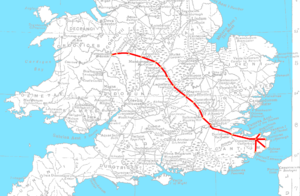
A map of the Saxon Watling Street overlaid on the Roman road network
A stretch of modern-day Watling Street in Buckinghamshire[a]
Route information
Length
276 mi (444 km)
[230 mi (370 km)] Rutupiae to Viroconium
Time period
Roman Britain Saxon Britain
Margary number
1
Major junctions
From
The Kentish ports
Major intersections
Canterbury, London, St Albans
To
Wroxeter
Location
Country
United Kingdom
Road network
Roman roads in Britannia
Watling Street is a historic route in England that crosses the River Thames at London and which was used in Classical Antiquity, Late Antiquity, and throughout the Middle Ages. It was used by the ancient Britons and paved as one of the main Roman roads in Britannia (Roman-governed Great Britain during the Roman Empire). The route linked Dover and London in the southeast, and continued northwest via St Albans to Wroxeter. The line of the road was later the southwestern border of the Danelaw with Wessex and Mercia, and Watling Street was numbered as one of the major highways of medieval England.
First used by the ancient Britons, mainly between the areas of modern Canterbury and St Albans using a natural ford near Westminster, the road was later paved by the Romans. It connected the ports of Dubris (Dover), Rutupiae (Richborough Castle), Lemanis (Lympne), and Regulbium (Reculver) in Kent to the Roman bridge over the Thames at Londinium (London). The route continued northwest through Verulamium (St Albans) on its way to Viroconium Cornoviorum (Wroxeter). Watling Street is traditionally cited as having been the location of the Romans' defeat of Boudica, though precisely where on the route is disputed.
The Roman Antonine Itinerary lists sites along the route of Watling Street as part of a longer route of 500 Roman miles connecting Richborough with Hadrian's Wall via Wroxeter. The continuation on to Blatobulgium (Birrens, Dumfriesshire) beyond Hadrian's Wall in modern Scotland may have been part of the same route, leading some scholars to call this Watling Street as well, although others restrict it to the southern leg.
In the early 18th century, England's first turnpike trust was established to pave the route through Bedfordshire and Buckinghamshire. In the early 19th century, the course between London and the Channel was paved and became known as the Great Dover Road.
The route from London to Wroxeter forms much of the A5 road. The route from Dover to London forms part of the A2 road. At various points along the historic route, the name Watling Street remains in modern use.
Cite error: There are <ref group=lower-alpha> tags or {{efn}} templates on this page, but the references will not show without a {{reflist|group=lower-alpha}} template or {{notelist}} template (see the help page).
WatlingStreet is a historic route in England that crosses the River Thames at London and which was used in Classical Antiquity, Late Antiquity, and throughout...
inns in Stony Stratford were staging posts for rival coach lines on WatlingStreet, the London–Birmingham turnpike road. It is said that local people,...
Sheppard Frere between 1957 and 1961 revealed a row of shops alongside WatlingStreet which had been burned at around 60 AD, but the full extent of the destruction...
Owing to this, some stretches or the entirety of Dere Street is sometimes referenced as "WatlingStreet", a name that appears on the 1885-1900 edition of...
settlements in the country. It was the Roman town of Lactodurum, located on WatlingStreet, today’s A5. In Saxon times, this was the frontier between the kingdom...
ancient WatlingStreet, but city residents and urban planners draw a crucial modern distinction: a road's main function is transportation, while streets facilitate...
Dilys Watling, 78". Wandsworth Times. Coronation Street star Dilys Watling dies aged 78 Metro, 16 August 2021. Retrieved 16 August 2021. Dilys Watling death:...
St Augustine, WatlingStreet, was an Anglican church which stood just to the east of St Paul's Cathedral in the City of London. First recorded in the 12th...
common. WatlingStreet was 10.1 m (33 ft) wide while the Fosse Way was little more than half that. Several unnamed roads were wider than WatlingStreet, such...
movement of traffic. The geography of Milton Keynes – the railway line, WatlingStreet, Grand Union Canal, M1 motorway – sets up a very strong north–south...
village in Hertfordshire, England, between Elstree and St Albans on WatlingStreet, with a population of 10,060. It is in the council district of Hertsmere...
also evidence of Iron Age burials in the area. In Roman times, the WatlingStreet road (now the A5) was built through the area and Lactodorum, probably...
posting station near the junction of WatlingStreet, the Roman military road to north Wales, and Icknield (or Ryknild) Street (now the A38). The site is now...
Romano-British fortified town which was on the Roman road later called WatlingStreet, which today is here, as in most places, the A5 road. Bannaventa straddles...
Suetonius brought Mona to terms and marched along the Roman road of WatlingStreet to Londinium (London), the rebels' next target, but judged he did not...
has a long history dating back to Roman times: The Roman road, the WatlingStreet (most of which later became part of the A5) ran through what is now...
miles (3 km) west of Long Buckby. In the era of Roman Britain, the WatlingStreet Roman road used the gap. The road here forms the A5, which for national...
Bread Street. Wenceslaus Hollar's “Exact Surveigh” of the City of London, 1667 shows it at the intersection of Friday Street and WatlingStreet, to the...
The Puritan, or the Widow of WatlingStreet, also known as The Puritan Widow, is an anonymous Jacobean stage comedy, first published in 1607. It is often...
Jack Stanley Watling (13 January 1923 – 22 May 2001) was an English actor. Watling was born 13 January 1923 in Chingford, east London, England. The son...
in part relate to the natural ford which is thought to have carried WatlingStreet over the Thames in the vicinity. Tradition dates the foundation to the...
joined Akeman Street and Ermin Way at Cirencester, crossed WatlingStreet at Venonis (High Cross) south of Leicester, and joined Ermine Street at Lincoln...
major road in London, England. The route originated as part of Roman WatlingStreet and, unusually in London, it runs for 10 miles in an almost perfectly...
Catuvellauni were in turn conquered by the Romans in 43 AD. The Roman road of WatlingStreet passed through the county, and an important Roman settlement, Lactodurum...
 Global Information