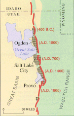
University of Utah students examine an exposure of the Wasatch Fault, a classic normal faultThe Wasatch Fault. Dates indicate approximately when the most recent strong (magnitude greater than 6.5) earthquake occurred on a fault segment.Liquefaction resulting from the Niigata Earthquake of Japan in 1964
The Wasatch Fault is an active fault located primarily on the western edge of the Wasatch Mountains in the U.S. states of Utah and Idaho. The fault is about 240 miles (390 kilometres) long, stretching from southern Idaho, through northern Utah, before terminating in central Utah near the town of Fayette. The fault is made up of ten segments, five of which are considered active.[1] On average the segments are approximately 25 miles (40 kilometres) long, each of which can independently produce earthquakes as powerful as local magnitude 7.5.[2] The five active segments from north to south are called the Brigham City Fault Segment, the Weber Fault Segment, the Salt Lake City Fault Segment, the Provo Fault Segment and the Nephi Fault Segment.[citation needed]
The Wasatch Fault is a normal (vertical motion) fault which forms the eastern boundary of the Basin and Range geologic province which comprises the geographic Great Basin. The Wasatch Mountains have been uplifted and tilted to the east by movement of the fault.[3] The average vertical displacement rate of the fault over its history is approximately 0.8–1.2 mm/yr.[4]
^"wasatch fault zone: Topics by Science.gov". www.science.gov. Retrieved 2019-02-28.
^"Surficial geologic map of the Wasatch fault zone, eastern part of Utah Valley, Utah County and parts of Salt Lake and Juab counties, Utah" (PDF).
^"How Big and How Frequent Are Earthquakes on the Wasatch Fault?". earthquake.usgs.gov. Retrieved 2020-03-19.
^Jewell, Paul W.; Bruhn, Ronald L. (2013). "Evaluation of Wasatch fault segmentation and slip rates using Lake Bonneville shorelines". Journal of Geophysical Research: Solid Earth. 118 (5): 2528–2543. Bibcode:2013JGRB..118.2528J. doi:10.1002/jgrb.50174.
The WasatchFault is an active fault located primarily on the western edge of the Wasatch Mountains in the U.S. states of Utah and Idaho. The fault is...
The Wasatch Range (/ˈwɑːsætʃ/ WAH-satch) or Wasatch Mountains is a mountain range in the western United States that runs about 160 miles (260 km) from...
metropolitan area Wasatch Back WasatchFault 2003 Utah snowstorm Payson-Dixon line "Megalopolis: Urban sprawl slowly blurs Wasatch Front towns, cities"...
Palace convention center. The Warm Springs Fault and the East Bench Fault, both offshoots of the WasatchFault, were found in 2021 to connect underneath...
The New Madrid Seismic Zone (NMSZ), sometimes called the New Madrid Fault Line, is a major seismic zone and a prolific source of intraplate earthquakes...
of major earthquake damage amplified by two offshoots of the nearby WasatchFault that join underneath the downtown area. Before settlement by members...
Bonneville Flood and then a massive, multi-segment earthquake on the WasatchFault caused surging and tsunami in Lake Bonneville with a surge wave over...
major active fault zone is the normal WasatchFault that throws down to the west. The footwall (upthrown part) is formed by the Wasatch Range with part...
This list covers all faults and fault-systems that are either geologically important[clarification needed] or connected to prominent seismic activity.[clarification...
recent fault movement and are used in seismotectonic analysis. Classic examples of faceted spurs can be found all along the Central WasatchFault, north-central...
boundary between the Salt Lake and Provo segments of the WasatchFault, and they are much faulted and locally involved in landslides. Lake Bonneville once...
the Wasatch Line and its various faults form the province's western edge. Faults that run parallel to the WasatchFault that lies along the Wasatch Range...
second-highest mountain in Utah's Wasatch Range. Timpanogos rises to an elevation of 11,752 ft (3,582 m) above sea level in the Uinta-Wasatch-Cache National Forest...
For example, the WasatchFault in the U.S. state of Utah closely parallels the state's most populous metropolitan area, the Wasatch Front (which includes...
west by the eastern fault scarp of the Sierra Nevada and spans over 500 miles (800 km) to its eastern border marked by the WasatchFault, the Colorado Plateau...
older than the Wasatch Mountains. As the mountains slowly rose over the last 15 million years by periodic faulting on the Wasatchfault, the river was...
cycle. The most studied earthquake faults (such as the Nankai megathrust, the Wasatchfault, and the San Andreas Fault) appear to have distinct segments...
Notably the cave cavity was formed initially by a series of faults running off of the Wasatchfault. Since that time hydrothermal water action perhaps similar...
landslide, in addition to the elevation gradient caused by the nearby WasatchFault. The Little Cottonwood Canyon watershed provides drinking water to much...
cycle. The most studied earthquake faults (such as the Nankai megathrust, the Wasatchfault, and the San Andreas fault) appear to have distinct segments...
Mountains fault zone. These two fault systems parallel the larger WasatchFault which runs to the east of Great Salt Lake. The faults are normal faults which...
mechanical faults on a locomotive Wasatch had repaired for them, former Klondike Mines Railway No. 4 “Klondike Kate”. Klondike Kate was returned from Wasatch to...
particularly potatoes and grain. Clay sediment is also common. The WasatchFault is visible throughout many parts of the valley due to the sharp displacement...
 Global Information