Worcester County, Massachusetts and Hillsborough County, New Hampshire, U.S.
Use
hiking, snowshoeing, cross-country skiing, other
Highest point
Pack Monadnock, 2,288 ft (697 m)
Lowest point
Spofford Gap, 1,226 ft (374 m)
Difficulty
easy, with moderately difficult sections
Season
easiest mid-spring to mid-fall
Hazards
deer ticks, weather, poison ivy
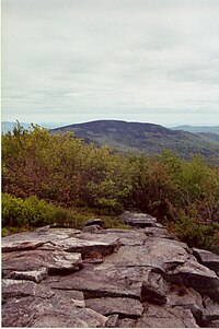
The Wapack Trail is one of the oldest public, interstate hiking trails in the United States. Opened in 1923,[1] it follows the Wapack Range north-south for 21 miles (34 km), between Mount Watatic in Ashburnham, Massachusetts, and North Pack Monadnock mountain in Greenfield, New Hampshire. It is designed primarily for day use by hikers, with minimal camping facilities.
The trail passes through the Massachusetts towns of Ashburnham and Ashby, and the New Hampshire towns of New Ipswich, Temple, Sharon, Peterborough, and Greenfield. It also goes over Temple Mountain, and through Miller State Park, Binney Hill Wilderness Preserve, and the Wapack National Wildlife Refuge, as well as numerous privately owned parcels of land. In New Ipswich it skirts Windblown Cross-Country Ski Area, which operated for four decades until closing in 2020.[2]
The trail is overseen by Friends of the Wapack, a non-profit group.[3] Aside from upgrading and maintaining the trail, the group is trying to have the entire length preserved from development.
The southern part of the Wapack Trail overlaps with the northern part of the Midstate Trail.
Friends of the Wapack patch
^"Monadnock Center, May 29, 2013 "Friends of the Wapack Trail celebrate 90 years"".
^Saari, Ashley (February 24, 2020). "New Ipswich cross-country ski area to close". Monadnock Ledger-Transcript. Retrieved February 27, 2020.
^"Friends of The Wapack – Once it's gone, it's gone forever". www.wapack.org.
The WapackTrail is one of the oldest public, interstate hiking trails in the United States. Opened in 1923, it follows the Wapack Range north-south for...
Wapack Range. It lies in Ashburnham, Massachusetts and Ashby, Massachusetts. The 22-mile (35 km) WapackTrail and the 92-mile (148 km) Midstate Trail...
700 m). The 22-mile (35 km) WapackTrail, one of the oldest interstate hiking trails in the United States, traverses it. The Wapack Range is also the northern...
Hampshire within the Wapack Range of mountains. It lies within the town of New Ipswich and is traversed by the 22-mile (35 km) WapackTrail. Kidder Mountain...
northern end of the Wapack Range of mountains. It lies within Greenfield and Temple, New Hampshire; the 22-mile (35 km) WapackTrail traverses the mountain...
Massachusetts. The wilderness contains more than a mile of the historic WapackTrail and features wetlands, rare natural communities, rocky ridges, and old-growth...
creating two smaller trails: the WapackTrail and the Monadnock-Sunapee Greenway. Chamberlain was also a promoter of hiking trails across New England....
within the town of New Ipswich and is traversed by the 22 mi (35 km) WapackTrail. The subordinate peak, Stony Top, 1,760 feet (540 m), forms the north...
is traversed by the 22-mile (35 km) WapackTrail. Barrett Mountain is located directly to the north along the Wapack ridgeline; Stony Top, a subordinate...
the grounds in perpetuity. These grounds were originally a farm. The WapackTrail runs along the Stony Top mountain ridge on one portion of the grounds...
Pack Monadnock Mountain. A 3-mile (5 km) segment of the 21-mile (34 km) WapackTrail passes through the refuge and provides wide views of the surrounding...
Fifty Finest AT – mountain is on the Appalachian Trail, a 2,170-mile (3,490 km) National Scenic Trail from Georgia to Maine 100 highest – listed on the...
Hampshire within the Wapack Range of mountains. It lies within New Ipswich and Temple, New Hampshire just off the 22 mi (35 km) WapackTrail on a 0.9-mile (1...
Railroad (1961) Pack Monadnock and North Pack Monadnock are two peaks in the Wapack Range, 11 miles (18 km) to the east across the Contoocook River valley from...
Governor of Arkansas Territory. The area is popular with hikers. The WapackTrail runs through the park, crossing over Pack Monadnock. In 2007, the state...
Pond Wildlife area access, WapackTrail - New Ipswich, NH". Waymarking. Retrieved February 18, 2017. "Bradford, NH Trails and Public Lands Map" (PDF)...
for education programs and available for rental, a universally accessible trail and boardwalk, a 19th-century gundalow replica, a replica Native American...
Road, the Mount Washington Cog Railway, the Appalachian Trail, or numerous other hiking trails from surrounding trailheads including Pinkham Notch, Crawford...
miles (0.8 km) of the summit. Picnic facilities are available, and hiking trails leave from the high point of the auto road to the summit. The park is named...
summit of Mount Lafayette and the Franconia Ridge Trail (also the Appalachian Trail). The Appalachian Trail continues north to Mount Washington and eventually...
Cathedral Road features picnic facilities and a 1⁄4-mile (0.40 km) hiking trail to Black Reservoir. New Hampshire portal "Hubbard Pond" (PDF). NH Fish and...
 Global Information