 Global Information
Wao Kele o Puna information
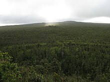
Wao Kele O Puna (Wao Kele) is Hawaiʻi's largest remaining lowland wet forest,[1] about 15 mi (24 km) south of the city of Hilo,[2] along the East Rift Zone of Kīlauea volcano on the Island of Hawaiʻi. The name means the upland rainforest of Puna. Puna is one of 9 districts on the island. Lava from Kīlauea continues to flow onto forest land.[3][needs update]
In 2006, the Trust for Public Land (TPL) purchased Wao Kele, ending a twenty-year struggle to prevent tapping the sizeable geothermal energy resources that lie below it. Opponents believe that the area is the home of the fire goddess Pele. It is also known as the Puna Forest Reserve, located just east of the Puʻu ʻŌʻō vent.
- ^ Cite error: The named reference
nytwas invoked but never defined (see the help page). - ^ Tindall, Ashley (September 1, 2007). "Wao Kele O Puna". Retrieved September 16, 2009.
- ^ Cite error: The named reference
hsb2007was invoked but never defined (see the help page).