 Global Information
Voznesenivskyi District information
Voznesenivskyi District
Вознесенівський район | |
|---|---|
Urban district | |
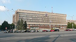 Zaporizhzhia Regional Administration is located in Voznesenivskyi District | |
 Voznesenivskyi District Location of the urban district on a map of Zaporizhzhia Oblast. | |
| Coordinates: 47°48′59″N 35°03′17″E / 47.81639°N 35.05472°E | |
| Country | |
| Municipality | Zaporizhzhia |
| Established | 1939 |
| Government | |
| • Deputy chairman | Lysenko Vitaly Vladimirovich[1] |
| Area | |
| • Total | 50.78 km2 (19.61 sq mi) |
| Population (2014)[2] | |
| • Total | |
| Time zone | UTC+2 (EET) |
| • Summer (DST) | UTC+3 (EEST) |
| Postal index | 330123 |
| Area code | +380 61 |
| KOATUU | 2310137300 |
| Website | w1 |
Voznesenivskyi District (Ukrainian: Вознесенівський район) is an administrative-territorial unit within the city of Zaporizhzhia, Ukraine named after the historical village of Voznesenky. The economic and symbolic center of the city and the Zaporizhzhia metropolitan area, it is Zaporizhzhia's oldest district and home to many of region's cultural, financial, educational and historical landmarks including Zaporizhzhia Regional Administration, Krytyy Market and Festival Square.
The district was formed on January 21, 1939, as Ordzhonikidzevskyi District in honor of Sergo Ordzhonikidze. It received its current name on February 19, 2016, by decree of the Ukrainian Government.[3]
- ^ "В Вознесеновском районе новый руководитель - Официальный сайт Запорожского городского совета". Zp.gov.ua. Retrieved 2023-03-03.
- ^ "Number of the population of the City of Zaporizhzhia" (PDF) (in Ukrainian). State Statistics Service of Ukraine in Zaporizhzhia Oblast. 20 June 2012. Retrieved 19 January 2015.
- ^ "Сайт Запорiзької мiської влади | Рішення міської ради". Archived from the original on 2016-03-06. Retrieved 2023-03-03.