For the former State Route 69, see State Route 69 (Virginia 1933-1951).
State Route 69
Lead Mine Road
Route information
Maintained by VDOT
Length
3.59 mi[1] (5.78 km)
Existed
1958–present
Major junctions
West end
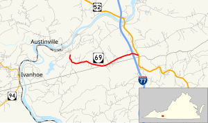
SR 636 in Austinville
Major intersections
I-77 at Poplar Camp
East end
US 52 at Poplar Camp
Location
Country
United States
State
Virginia
Counties
Wythe, Carroll
Highway system
Virginia Routes
Interstate
US
Primary
Secondary
Byways
History
HOT lanes
← SR 68
→ SR 70
State Route 69 (SR 69) is a primary state highway in the U.S. state of Virginia. Known as Lead Mine Road, the state highway runs 3.59 miles (5.78 km) from SR 636 in Austinville east to U.S. Route 52 (US 52) in Poplar Camp. SR 69 is the last remnant of a much longer route. At its peak from 1940 to 1945, this route (then numbered State Route 81) ran from State Route 91 at Lodi east via St. Clair Bottom, Sugar Grove, Cedar Springs, Speedwell, Porters Crossroads, and Austinville to today's SR 69. However, it was never fully continuous; portions from Sugar Grove to Cedar Springs and west of Porters Crossroads to east of Austinville were secondary routes. The full length of this route as it existed and was planned is now part of SR 762, part of SR 660, all of SR 650, part of SR 16 (and SR 695, its former alignment at Sugar Grove), all of SR 614, part of SR 749, part of US 21, part of SR 690, a small piece of SR 642, part of SR 619, part of SR 636, and SR 69.
^Cite error: The named reference VDOT Traffic Data was invoked but never defined (see the help page).
and 28 Related for: Virginia State Route 69 information
West VirginiaRoute69 is a north–south state highway located within Wetzel County, West Virginia. The southern terminus of the route is at U.S. Route 250...
In the US state of Virginia, some state highways have been specifically designated to serve state parks and state institutions. StateRoute 217 and the...
StateRoute 168 is a primary state highway in the South Hampton Roads region of the U.S. state of Virginia. It runs from the border with North Carolina...
StateRoute 31 (SR 31) is a primary state highway in the U.S. state of Virginia. The state highway runs 24.56 miles (39.53 km) from U.S. Route 460 (US...
StateRoute 16 is a primary state highway in the southwest part of the U.S. state of Virginia. It runs from the North Carolina border at North Carolina...
StateRoute 605 (SR 605) in the U.S. state of Virginia is a secondary route designation applied to multiple discontinuous road segments among the many...
StateRoute 622 (SR 622) in the U.S. state of Virginia is a secondary route designation applied to multiple discontinuous road segments among the many...
StateRoute 603 (SR 603) in the U.S. state of Virginia is a secondary route designation applied to multiple discontinuous road segments among the many...
StateRoute 601 (SR 601) in the U.S. state of Virginia is a secondary route designation applied to multiple discontinuous road segments among the many...
StateRoute 600 (SR 600) in the U.S. state of Virginia is a secondary route designation applied to multiple discontinuous road segments among the many...
StateRoute 609 (SR 609) in the U.S. state of Virginia is a secondary route designation applied to multiple discontinuous road segments among the many...
StateRoute 602 (SR 602) in the U.S. state of Virginia is a secondary route designation applied to multiple discontinuous road segments among the many...
StateRoute 604 (SR 604) in the U.S. state of Virginia is a secondary route designation applied to multiple discontinuous road segments among the many...
VirginiaStateRoute 3 is a primary state highway in the U.S. state of Virginia that extends from the town of Culpeper south and eastwardly to Gloucester...
StateRoute 33 (SR 33) is a primary state highway in the U.S. state of Virginia. The state highway runs 72.23 miles (116.24 km) from U.S. Route 33 and...
StateRoute 640 (SR 640) in the U.S. state of Virginia is a secondary route designation applied to multiple discontinuous road segments among the many...
StateRoute 628 (SR 628) in the U.S. state of Virginia is a secondary route designation applied to multiple discontinuous road segments among the many...
StateRoute 618 (SR 618) in the U.S. state of Virginia is a secondary route designation applied to multiple discontinuous road segments in the many counties...
StateRoute 621 (SR 621) in the U.S. state of Virginia is a secondary route designation applied to multiple discontinuous road segments among the many...
StateRoute 612 (SR 612) in the U.S. state of Virginia is a secondary route designation applied to multiple discontinuous road segments among the many...
StateRoute 619 (SR 619) in the U.S. state of Virginia is a secondary route designation applied to multiple discontinuous road segments among the many...
StateRoute 607 (SR 607) in the U.S. state of Virginia is a secondary route designation applied to multiple discontinuous road segments among the many...
StateRoute 617 (SR 617) in the U.S. state of Virginia is a secondary route designation applied to multiple discontinuous road segments among the many...
StateRoute 624 (SR 624) in the U.S. state of Virginia is a secondary route designation applied to multiple discontinuous road segments among the many...
 Global Information