City of Richmond, Chesterfield, City of Hopewell, Prince George, Surry, Isle of Wight, City of Suffolk
Highway system
Virginia Routes
Interstate
US
Primary
Secondary
Byways
History
HOT lanes
← SR 9
→ US 11
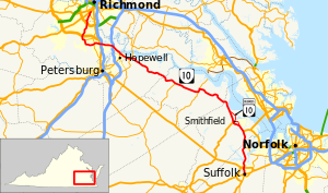
State Route 10 (SR 10) is a primary state highway in the U.S. state of Virginia. The state highway runs 93.58 miles (150.60 km) from U.S. Route 360 (US 360) in Richmond east to SR 337 in Suffolk. SR 10 is a major suburban highway through Chesterfield County between the Southside of Richmond and Hopewell. Between Hopewell and Smithfield, which is served by SR 10 Business, the state highway passes through rural Prince George, Surry, and Isle of Wight counties, following the route of an old stagecoach road through an area that features many of the preserved James River plantations. SR 10 runs concurrently with US 258 and SR 32 between Smithfield and Suffolk.
^Cite error: The named reference VDOT Traffic Data was invoked but never defined (see the help page).
and 19 Related for: Virginia State Route 10 information
StateRoute10 (SR 10) is a primary state highway in the U.S. state of Virginia. The state highway runs 93.58 miles (150.60 km) from U.S. Route 360 (US...
In the US state of Virginia, some state highways have been specifically designated to serve state parks and state institutions. StateRoute 217 and the...
VirginiaStateRoute 5 (SR 5) is a primary state highway in the Commonwealth of Virginia. It runs between the independent cities of Richmond and Williamsburg...
Virginia state institutions, see State highways serving Virginiastate institutions. StateRoute 34 is the designation for Hodges Street, which runs 0.54...
StateRoute 31 (SR 31) is a primary state highway in the U.S. state of Virginia. The state highway runs 24.56 miles (39.53 km) from U.S. Route 460 (US...
West VirginiaRoute10 is a north–south route from Cabell County to Mercer County in the western and southern regions of West Virginia. Mostly a two-lane...
StateRoute 40 (SR 40) is a primary state highway in the southern part of the U.S. state of Virginia. It runs from SR 8 at Woolwine east to SR 10 at Spring...
StateRoute 168 is a primary state highway in the South Hampton Roads region of the U.S. state of Virginia. It runs from the border with North Carolina...
VirginiaStateRoute 3 is a primary state highway in the U.S. state of Virginia that extends from the town of Culpeper south and eastwardly to Gloucester...
StateRoute 600 (SR 600) in the U.S. state of Virginia is a secondary route designation applied to multiple discontinuous road segments among the many...
StateRoute 615 (SR 615) in the U.S. state of Virginia is a secondary route designation applied to multiple discontinuous road segments among the many...
StateRoute 622 (SR 622) in the U.S. state of Virginia is a secondary route designation applied to multiple discontinuous road segments among the many...
StateRoute 642 (SR 642) in the U.S. state of Virginia is a secondary route designation applied to multiple discontinuous road segments among many counties...
StateRoute 236 (SR 236) is a primary state highway in the U.S. state of Virginia. The state highway runs 15.63 miles (25.15 km) from U.S. Route 29 and...
StateRoute 610 (SR 610) in the U.S. state of Virginia is a secondary route designation applied to multiple discontinuous road segments among the many...
StateRoute 640 (SR 640) in the U.S. state of Virginia is a secondary route designation applied to multiple discontinuous road segments among the many...
StateRoute 16 is a primary state highway in the southwest part of the U.S. state of Virginia. It runs from the North Carolina border at North Carolina...
StateRoute 120 (SR 120) is a primary state highway in the U.S. state of Virginia. Known as Glebe Road, the state highway runs 9.10 miles (14.65 km) from...
 Global Information