 Global Information
Vilakkupara information
This article needs additional citations for verification. (July 2023) |
Vilakkupara
വിളക്കുപാറ | |
|---|---|
village | |
| Coordinates: 8°56′31″N 76°59′06″E / 8.942°N 76.985°E | |
| Country | |
| State | Kerala |
| District | Kollam |
| Government | |
| • Body | Yeroor Panchayat |
| Languages | |
| • Official | Malayalam, English |
| Time zone | UTC+5:30 (IST) |
| PIN | 691312 |
| Telephone code | 0475 |
| Vehicle registration | KL-25 |
| Literacy | 98 %% |
| Lok Sabha constituency | Kollam |
| Civic agency | Yeroor Panchayat |
| Website | [[1] www |
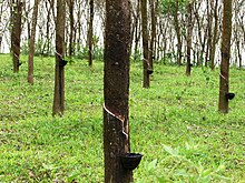
Vilakkupara is a village in Punalur Taluk, Kollam District, Kerala State, India. Vilakkupara lies 58 km (36 mi) to the east of Kollam, the District headquarters, and 12 km (7 mi) to the southeast of Punalur on Kollam-Thirumangalam National Highway (N.H-744). It is 72 km (45 mi) north of Thiruvananthapuram, the State Capital. It belongs to the Yeroor Gram panchayat , Punalur Assembly Constituency, and is a part of the Kollam Lok Sabha constituency.