Global Information Lookup Global Information

Vermlandsgade information


Vermlandsgade
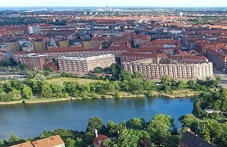
Vermlandsgade seen from the top of the Church of Our Saviour.
Length1,110 m (3,640 ft)
LocationCopenhagen, Denmark
QuarterAmagerbro
Postal code2300
Nearest metro stationAmagerbro
Northwest endChristmas Møllers Plads
Major
junctions
Prags Boulevard
Southeast endHolmbladsgade

Vermlandsgade (lit. "Värmland Street") is a major street on the northeastern part of Amager, Copenhagen, Denmark. It runs from Christmas Møllers Plads in the west to a roundabout on Prags Boulevard in the east and then continues south to Holmbladsgade.

and 3 Related for: Vermlandsgade information

Request time (Page generated in 1.1452 seconds.)

Vermlandsgade

Last Update:

Vermlandsgade (lit. "Värmland Street") is a major street on the northeastern part of Amager, Copenhagen, Denmark. It runs from Christmas Møllers Plads...

Word Count : 419

Peter Beier

Last Update:

Rotundenm Strandvejen 64A, Hellerup Lyngby Hovedgade 47, Kongens Lyngby Vermlandsgade 51 (Meny), Amager Nærumvænge Torv 18 (Meny), Nærum Bagsværd Hovedgade...

Word Count : 387

Super bikeways in metropolitan Copenhagen

Last Update:

Langebro, Amager Boulevard, Ved Stadsgraven, Christmas Møllers Plads, Vermlandsgade, Uplandsgade, Prags Boulevard, Ved Amagerbanen, Øresund Station, Krimsvej...

Word Count : 395

PDF Search Engine © AllGlobal.net