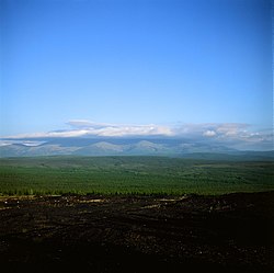
Verkhoyansky District (Russian: Верхоя́нский улу́с; Yakut: Үөһээ Дьааҥы улууһа, Üöhee Caaŋı uluuha, IPA:[ˈyøheːɟaːŋɯuluːha]) is an administrative[1] and municipal[7] district (raion, or ulus), one of the thirty-four in the Sakha Republic, Russia. It is located in the northern central part of the republic and borders with Ust-Yansky District in the northeast, Momsky District in the east, Tomponsky District in the south, Kobyaysky District in the southwest, Eveno-Bytantaysky National District in the west, and with Bulunsky District in the northwest. The area of the district is 137,400 square kilometers (53,100 sq mi).[3] Its administrative center is the urban locality (a settlement) of Batagay.[3] Population: 12,815 (2010 Russian census);[4] 13,666 (2002 Census);[10]24,259 (1989 Soviet census).[11] The population of Batagay accounts for 34.1% of the district's total population.[4]
^ abConstitution of the Sakha Republic
^Cite error: The named reference SEPM was invoked but never defined (see the help page).
^ abcdeRegistry of the Administrative-Territorial Divisions of the Sakha Republic
^ abcRussian Federal State Statistics Service (2011). Всероссийская перепись населения 2010 года. Том 1 [2010 All-Russian Population Census, vol. 1]. Всероссийская перепись населения 2010 года [2010 All-Russia Population Census] (in Russian). Federal State Statistics Service.
^"26. Численность постоянного населения Российской Федерации по муниципальным образованиям на 1 января 2018 года". Federal State Statistics Service. Retrieved January 23, 2019.
^The count of urban-type settlements may include the work settlements, the resort settlements, the suburban (dacha) settlements, as well as urban-type settlements proper.
^ abLaw #172-Z #351-III
^Law #173-Z #354-III
^"Об исчислении времени". Официальный интернет-портал правовой информации (in Russian). June 3, 2011. Retrieved January 19, 2019.
^Federal State Statistics Service (May 21, 2004). Численность населения России, субъектов Российской Федерации в составе федеральных округов, районов, городских поселений, сельских населённых пунктов – районных центров и сельских населённых пунктов с населением 3 тысячи и более человек [Population of Russia, Its Federal Districts, Federal Subjects, Districts, Urban Localities, Rural Localities—Administrative Centers, and Rural Localities with Population of Over 3,000] (XLS). Всероссийская перепись населения 2002 года [All-Russia Population Census of 2002] (in Russian).
^Всесоюзная перепись населения 1989 г. Численность наличного населения союзных и автономных республик, автономных областей и округов, краёв, областей, районов, городских поселений и сёл-райцентров [All Union Population Census of 1989: Present Population of Union and Autonomous Republics, Autonomous Oblasts and Okrugs, Krais, Oblasts, Districts, Urban Settlements, and Villages Serving as District Administrative Centers]. Всесоюзная перепись населения 1989 года [All-Union Population Census of 1989] (in Russian). Институт демографии Национального исследовательского университета: Высшая школа экономики [Institute of Demography at the National Research University: Higher School of Economics]. 1989 – via Demoscope Weekly.
and 23 Related for: Verkhoyansky District information
administratively belongs to the Sakha Republic, Russia, and is in its VerkhoyanskyDistrict. The depression is in the form of a one-kilometre-long gash up to...
locality (an urban-type settlement) and the administrative center of VerkhoyanskyDistrict of the Sakha Republic, Russia, located on the Yana River. As of...
Ust-Aldansky and Kobyaysky Districts in the west, and with VerkhoyanskyDistrict in the north and northwest. The area of the district is 135,800 square kilometers...
ICAO: UEBB) is an airport serving the urban locality of Batagay, VerkhoyanskyDistrict, in the Sakha Republic of Russia, ashore the Yana River. Russia...
Far Eastern Federal District The Far Eastern Federal District (Russian: Дальневосто́чный федера́льный о́круг, romanized: Dal'nevostochnyy federal'nyy...
Central parts of the Sakha Republic (Oymyakonsky District, Ust-Yansky District and VerkhoyanskyDistrict) The Jewish Autonomous Oblast Primorsky Krai Between...
Ust-Yansky District in the east, VerkhoyanskyDistrict in the southeast, Eveno-Bytantaysky and Zhigansky Districts in the south, Olenyoksky District in the...
Ust-Aldansky District Tomtor, Borulakhsky Rural Okrug, VerkhoyanskyDistrict, Sakha Republic, a selo in Borulakhsky Rural Okrug of VerkhoyanskyDistrict Tomtor...
there are no settlements near its course. Its basin falls within VerkhoyanskyDistrict. The Tykakh is a left tributary of the Yana. It has its sources...
Yunkyur, Olyokminsky District, Sakha Republic, a selo in Malzhagarsky Rural Okrug of Olyokminsky District Yunkyur, VerkhoyanskyDistrict, Sakha Republic,...
Ыннах) and as Mother Mountain (Russian: Мать-Гора), is a mountain in VerkhoyanskyDistrict, Yakutia, Russian Federation. The mountain has been classified as...
Oblast Khabarovsk Krai Sakha Republic Oymyakonsky District Ust-Yansky DistrictVerkhoyanskyDistrict United States Guam Northern Mariana Islands Australia...
Russia. Until 2018 it encompassed the same area as the Far Eastern Federal District, which then was enlarged by Buryatia Republic and Zabaykalsky Krai. In...
–Present Flag of Verkhnevilyuysky District ?–Present Flag VerkhoyanskyDistrict 2003–Present Flag of Vilyuysky District A horizontal tricolor of blue, yellow...
Eastern Federal District Magadan Oblast, Sakhalin Oblast and Sakha Republic (eastern part: Oymyakonsky, Ust-Yansky, and Verkhoyanskydistricts) Solomon Islands...
river flows north of the Arctic Circle. Its basin falls within VerkhoyanskyDistrict. The Baky is a left tributary of the Yana. It has its sources in...
Republic. Born on January 12, 1964, in the Batagay village, Verkhoyansk district of the Yakut ASSR. His father was a doctor, and mother was a teacher. Parents...
Russia: Saydy, Tomponsky District, Sakha Republic, a selo in Ynginsky Rural Okrug of Tomponsky District Saydy, VerkhoyanskyDistrict, Sakha Republic, a selo...
world. It is here in central Yakutia in the East Siberian taiga in VerkhoyanskyDistrict of the Sakha Republic that the largest retrogressive thaw slump...
in the mountains. The district was established on May 20, 1931. Prior to that, its territory was a part of VerkhoyanskyDistrict.[citation needed] The...
 Global Information