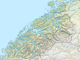
Vanylvsfjorden is a fjord in western Norway, on the border of Vestland and Møre og Romsdal counties. The 30-kilometre (19 mi) long fjord runs between the mainland of Vanylven Municipality and the Stad peninsula of Stad Municipality, with the islands of Sande Municipality lying in the mouth of the fjord. The inner part of the fjord branches into the Syltefjorden and Kjødepollen. The deepest part of the fjord reaches about 252 metres (827 ft) below sea level, just northeast of the village of Borgundvåg.[1][2]
There are settlements all around the shoreline of the fjord and on some of the islands at the mouth of the fjord. Some of the larger, more notable villages on the shore of the fjord include Fiskåbygd, Sylte, Slagnes, Åheim (all in Vanylven) and Leikanger and Borgundvåg (in Selje).
The Haugsholmen Lighthouse is located in the outer part of the fjord.[1]
^ abEvensen, Knut Harald, ed. (2010). NAF Veibok 2010–2012 (in Norwegian) (29 ed.). Oslo: Norges Automobil-Forbund. p. 60.
^Godal, Anne Marit (ed.). "Vanylvsfjorden". Store norske leksikon (in Norwegian). Oslo: Norsk nettleksikon. Retrieved 23 August 2013.
Vanylvsfjorden is a fjord in western Norway, on the border of Vestland and Møre og Romsdal counties. The 30-kilometre (19 mi) long fjord runs between the...
Municipality. The municipality (originally the parish) is named after the Vanylvsfjorden (Old Norse: Vaniflir). The meaning of the first element is uncertain...
through the Mannseidet isthmus to the Kjødspollen (the inner part of the Vanylvsfjorden), the narrowest but innermost place of the peninsula. The other option...
is located on the tiny island of Vestre Frekøy, in the mouth of the Vanylvsfjorden, about 2.5 kilometres (1.6 mi) southwest of the island of Kvamsøya....
Norway. It is located in the village of Slagnes, on the shore of the Vanylvsfjorden. It is the church for the Vanylven parish which is part of the Søre...
in Møre og Romsdal county, Norway. The village is located along the Vanylvsfjorden, about 4 kilometres (2.5 mi) north of the village of Åheim. Slagnes...
It is located in the village of Åheim, on the eastern shore of the Vanylvsfjorden. It is now a museum and historic site, but the church was once the main...
the Sildagapet bay on the west, the North Sea to the north, and the Vanylvsfjorden to the northeast. Selje municipality was bordered to the south and west...
 Global Information