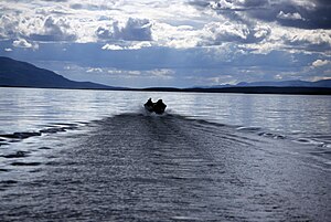
The Unalakleet River (Iñupiaq: Uŋalaqłiit Kurgat) in the U.S. state of Alaska flows southwest 90 miles (145 km) from the Kaltag Mountains to near the town of Unalakleet, on Norton Sound of the Bering Sea.[3]
In 1980, the upper 80 miles (130 km) of the river was protected as "wild" as part of the National Wild and Scenic Rivers System.[4] Managed by the Bureau of Land Management, the wild segment of the river is fished for king and silver salmon, Arctic grayling, and char.[4] Other forms of recreation along the river include boating and camping in summer and snowmobiling, dog mushing, ice fishing, hunting, and trapping in winter.[5] For part of its length, the Iditarod Trail runs along the Unalakleet.[5]
^ abc"Unalakleet River". Geographic Names Information System. United States Geological Survey. January 1, 2000. Retrieved September 27, 2013.
^Derived by entering source coordinates in Google Earth.
^ abOrth, Donald J.; United States Geological Survey (1971) [1967]. Dictionary of Alaska Place Names: Geological Survey Professional Paper 567(PDF). University of Alaska Fairbanks. p. 1008. Archived from the original (PDF) on October 17, 2013. Retrieved September 27, 2013. {{cite book}}: Unknown parameter |agency= ignored (help)
^ ab"Unalakleet River, Alaska". National Wild and Scenic Rivers System. Retrieved September 27, 2013.
^ ab"Unalakleet National Wild River: Recreation". Bureau of Land Management. February 22, 2011. Archived from the original on October 4, 2015. Retrieved September 27, 2013.
The UnalakleetRiver (Iñupiaq: Uŋalaqłiit Kurgat) in the U.S. state of Alaska flows southwest 90 miles (145 km) from the Kaltag Mountains to near the town...
community about 150 miles (240 km) southeast of Nome at the mouth of the UnalakleetRiver. The complex includes the main school building, a light plant, a warehouse...
the Tweto family from Unalakleet, Alaska who run the Alaska airline Era Alaska. They operate the hub operations from Unalakleet. The show also features...
River Ungalik River – 90 miles (140 km) Shaktoolik River – 90 miles (140 km) UnalakleetRiver – 90 miles (140 km) South River North River – 60 miles (97 km)...
built around Norton Sound, through a pass along the UnalakleetRiver, and along the Yukon River to connect to Manley Hot Springs Road – in other words...
Unalakleet Airport (IATA: UNK, ICAO: PAUN, FAA LID: UNK) is a state-owned public-use airport located one nautical mile (2 km) north of the central business...
"it's still a long way to Nome". The trail normally runs down the UnalakleetRiver into town, but shifted 7 miles (11 km) due to water overflowing the...
Golovin, Stebbins, White Mountain, Koyuk, Shaktoolik, St. Michael, and Unalakleet are on the shores or waterways flowing into Norton Sound. The Iditarod...
in Anchorage, Aniak, Bethel, Emmonak, Kotzebue, Nome, St. Mary's, and Unalakleet. Offering primarily cargo services, Ryan Air also operates scheduled passenger...
Service Salmon River in Oregon Ontonagon River, Michigan Wilson Creek Red River, New Mexico Lower Flathead River Loxhatchee River Taunton River White Clay...
Mulchatna River Noatak River Nowitna River Salmon River Selawik River Sheenjek River Tinayguk River Tlikakila RiverUnalakleetRiver Wind River State Comprehensive...
Kuyukuk, the word for 'river' in the coastal speech of the Chnagmyut."). The "Chnagmyut" lived between St. Michael and Unalakleet. Id. at page 104 (map)...
runs through a 1,000-foot (304.80 m) pass down to the Iñupiat town of Unalakleet, on the shore of the Bering Sea. In the early years of the Iditarod, the...
Moscow River Unk, Shropshire, river in Shropshire, England University of Nebraska at Kearney, often abbreviated UNK Nebraska–Kearney Lopers Unalakleet Airport...
The Alagnak River is a 64-mile (103 km) tributary of the Kvichak River in the U.S. state of Alaska. It has a catchment area of approximately 1400 square...
The Gulkana River[pronunciation?] is a 60-mile (97 km) tributary of the Copper River in the U.S. state of Alaska. Beginning near the southeastern end of...
The Alatna River[pronunciation?] is a federally designated wild and scenic river partially contained within the boundaries of Gates of the Arctic National...
The Fortymile River is a 60-mile (97 km) tributary of the Yukon River in the U.S. state of Alaska and the Canadian territory of Yukon. Beginning at the...
with hubs at Ralph Wien Memorial Airport in Kotzebue and Unalakleet Airport north of Unalakleet, Alaska. Bering also flies to Anadyr and Provideniya in...
Alaska; Detachment 5 at Middleton Island AFS, Alaska; Detachment 6 at Unalakleet AFS, Alaska; Detachment 7 at Bethel AFS, Alaska; Detachment 8 at Indian...
Kaktovik, Anaktuvuk Pass); (2) Bering Straits Association (Seward Peninsula, Unalakleet, Saint Lawrence Island); (3) Northwest Alaska Native Association (Kotzebue);...
to Kotzebue, with another managed by William Kjellmann going between Unalakleet and Nome. Distances of 30–50 miles were covered by the service, with the...
operates the Eagle River Nature Center which exhibits interpretive information on wildlife and geological features. The basin of the Eagle River can be accessed...
74°24’ N. 1834 – George Back descends the Back River to Chantrey Inlet. 1837 – Glazunov ascends the Unalakleet and portages to the middle Yukon. 1837–39 –...
 Global Information