Global Information Lookup Global Information

Umtanum Ridge Water Gap information


Umtanum Ridge Water Gap
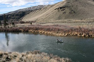
A view north from Umtanum Ridge into the Yakima River Canyon from the west of the Yakima River.
Umtanum Ridge Water Gap is located in Washington (state)
Umtanum Ridge Water Gap
Map of Washington state
Locationcentral Washington state
Coordinates46°51′00″N 120°32′40″W / 46.85000°N 120.54444°W / 46.85000; -120.54444
Designated1980
Photo showing roads parallel to the Yakima River as it discharges from the Yakima River Canyon outside of the city of Selah.
Fly fishing from drift boat on the Yakima River in the Yakima River Canyon.

Umtanum Ridge Water Gap is a geologic feature in Washington state in the United States. It includes the Yakima Canyon (or "Yakima River Canyon"), and is located between the cities of Ellensburg and Yakima in central Washington.[1] Washington State Route 821 (formerly numbered "U.S. Route 97") was once the main route between Ellensburg and Yakima.[2][3] The old highway still runs close to the river through the canyon, with Interstate 82 (which replaced the old highway) currently carrying most traffic between Ellensburg and Yakima on large bridges nearby.

The Umtanum Ridge Water Gap was designated a National Natural Landmark in 1980.[4] The landmark is characterized by a series of steep-sided ridges in the Columbia River basalt which are cut through axially by the Yakima River. A water gap was cut by the Yakima River through anticlines named "Manastash Ridge" and "Umtanum Ridge". These anticlines are part of the Yakima Fold Belt near the western edge of the Columbia River Plateau.

  1. ^ "Landmark Highlights 2021 (U.S. National Park Service)". www.nps.gov. Retrieved 2022-06-10.
  2. ^ Babcock (2000)
  3. ^ Pub:Benchmark (2002)
  4. ^ "Umtanum Ridge Water Gap". nps.gov. National Park Service. Archived from the original on 2015-09-14.

and 6 Related for: Umtanum Ridge Water Gap information

Request time (Page generated in 0.8042 seconds.)

Umtanum Ridge Water Gap

Last Update:

Umtanum Ridge Water Gap is a geologic feature in Washington state in the United States. It includes the Yakima Canyon (or "Yakima River Canyon"), and...

Word Count : 641

Umtanum Ridge

Last Update:

and on the south by Yakima Ridge. The Yakima River cuts through the ridge at the Umtanum Ridge Water Gap. The name Umtanum comes from Sahaptin, probably...

Word Count : 227

Yakima Ridge

Last Update:

Gap. The river cut through other ridges at locations including Umtanum Ridge Water Gap and Union Gap at Ahtanum Ridge. "Coffin". NGS Data Sheet. National...

Word Count : 231

List of National Natural Landmarks in Washington

Last Update:

Delta Sims Corner Eskers and Kames Steptoe and Kamiak Buttes Umtanum Ridge Water Gap Wallula Gap Withrow Moraine and Jameson Lake Drumlin Field Davis Canyon...

Word Count : 135

Yakama

Last Update:

the Yakima River. Síla-ħlama (along the Yakima River between Wenas and Umtanum creeks, the northernmost Lower Yakama Band) Wínas-ħlama (along Wenas Creek...

Word Count : 2950

Columbia River Basalt Group

Last Update:

026 cu mi) of basalt in layers of 10 to 60 m (33 to 197 ft) in thickness. The Umtanum flow has been estimated at 2,750 km3 (660 cu mi) in layers 50 m (160 ft)...

Word Count : 4201

PDF Search Engine © AllGlobal.net