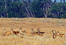
The Umatilla National Wildlife Refuge is located on and around the Columbia River about 15 miles (24 km) northwest of Hermiston, Oregon and includes 8,907 acres (3,605 ha) in Oregon, and 14,876 acres (6,020 ha) in Washington.[2] It was established in 1969 to help mitigate habitat lose due to the flooding that occurred following the construction of the John Day Dam. The refuge is popular with birdwatchers and wildlife enthusiasts.
The refuge is a varied mix of open water, sloughs, shallow marsh, seasonal wetlands, cropland, islands, and shrub-steppe upland habitats. It is divided into six units—two in Oregon, three in Washington, and one in the middle of the Columbia River. The scarcity of wetlands and other natural habitats in this area make Umatilla National Wildlife Refuge vital to migrating waterfowl, bald eagles, colonial nesting birds, and other migratory and resident wildlife. It is strategically located within the Pacific Flyway to provide Arctic nesting geese and ducks a wintering site and a resting stopover.
^"Umatilla National Wildlife Refuge". Geographic Names Information System. United States Geological Survey, United States Department of the Interior.
^ ab"Annual Report of Lands as of September 30, 2009" (PDF). United States Fish and Wildlife Service.
and 24 Related for: Umatilla National Wildlife Refuge information
there are 588 NationalWildlifeRefuges in the United States, with the addition of the Green River NationalWildlifeRefuge. Refuges that have boundaries...
Malheur NationalWildlifeRefuge is a NationalWildlifeRefuge located roughly 30 miles (48 km) south of the city of Burns in Oregon's Harney Basin. Administered...
The Turnbull NationalWildlifeRefuge is located six miles (10 km) south of Cheney, Washington, on the eastern edge of the Columbia Basin in Spokane County...
The Dungeness NationalWildlifeRefuge is located near the town of Sequim in Clallam County in the U.S. state of Washington, on the Strait of Juan de Fuca...
Columbia NationalWildlifeRefuge is a scenic mixture of rugged cliffs, canyons, lakes, and sagebrush grasslands. Formed by fire, ice, floods, and volcanic...
The Lower Klamath NationalWildlifeRefuge is a NationalWildlifeRefuge of the United States on the border between California and Oregon. It is operated...
Ridgefield NationalWildlifeRefuge is a NationalWildlifeRefuge and is overseen by the United States Fish and Wildlife Service. The refuge borders the...
Three Arch Rocks NationalWildlifeRefuge is a U.S. NationalWildlifeRefuge off the northern Oregon Coast. It is located on the central coast of Tillamook...
Ankeny NationalWildlifeRefuge is located in the fertile Willamette Valley of northwestern Oregon, 12 miles (19 km) south of Salem. The valley was once...
Islands NationalWildlifeRefuge is a U.S. NationalWildlifeRefuge off the southwestern Oregon Coast. It is one of six NationalWildlifeRefuges comprising...
The UmatillaNational Forest, in the Blue Mountains of northeast Oregon and southeast Washington, covers an area of 1.4 million acres (5,700 km2). In...
Willapa NationalWildlifeRefuge is a NationalWildlifeRefuge located on the shores of Willapa Bay in Washington, United States. It comprises 11,000 acres...
Toppenish NationalWildlifeRefuge is located on the Yakama Indian Reservation about 6 miles south of Toppenish, Washington, in the agriculturally intensive...
The San Juan Islands NationalWildlifeRefuge is in the San Juan Islands of the Salish Sea, north of Puget Sound, in the State of Washington. Created in...
all three National Forests in Florida, but there are local ranger district offices located in Silver Springs and Umatilla. The Ocala National Forest lies...
The Tualatin River NationalWildlifeRefuge is a 1,856 acres (751 ha) wetlands and lowlands sanctuary in the northwestern part of the U.S. state of Oregon...
 Global Information