"Ucayali" redirects here. For other uses, see Ucayali (disambiguation).
This article needs additional citations for verification. Please help improve this article by adding citations to reliable sources. Unsourced material may be challenged and removed. Find sources: "Ucayali River" – news · newspapers · books · scholar · JSTOR(February 2015) (Learn how and when to remove this message)
River in Peru
Ucayali River
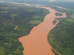
Confluence of the Tambo (from bottom) and Urubamba Rivers (background right) forming the Ucayali River (background left)
Map of the Amazon Basin with the Ucayali River highlighted
Location
Country
Peru
Physical characteristics
Source
confluence of the Tambo and Urubamba Rivers
• location
Atalaya, Ucayali, Peru
Mouth
Amazon River
• location
confluence with Marañón River, Loreto, Peru
Length
2,238 km (1,391 mi)[1]
1,460 km (910 mi)[2]
Basin size
351,549 km2 (135,734 sq mi)[1]
Discharge
• location
Requena, Peru
• average
(Period of data: 1990-2006)13,385 m3/s (472,700 cu ft/s)[4]
13,500 m3/s (480,000 cu ft/s)
(Confluence of Marañón: ~13,800 m3/s (490,000 cu ft/s))
• minimum
3,000 m3/s (110,000 cu ft/s)[3]
• maximum
28,000 m3/s (990,000 cu ft/s)[3]
Discharge
• location
Pucallpa, Peru (Basin size: 260,733 km2 (100,670 sq mi)
• average
(Period of data: 1990-2006)8,931.2 m3/s (315,400 cu ft/s)[4]
The Ucayali River (Spanish: Río Ucayali, IPA:[ˈri.owkaˈʝali]) is the main headstream of the Amazon River. It rises about 110 km (68 mi) north of Lake Titicaca, in the Arequipa region of Peru and becomes the Amazon at the confluence of the Marañón close to Nauta city. The city of Pucallpa is located on the banks of the Ucayali.
^ ab"Archived copy" (PDF). Archived from the original (PDF) on 2021-11-13. Retrieved 2023-04-06.{{cite web}}: CS1 maint: archived copy as title (link)
^Ziesler, R.; Ardizzone, G.D. (1979). "Amazon River System". The Inland waters of Latin America. Food and Agriculture Organization of the United Nations. ISBN 92-5-000780-9. Archived from the original on 8 November 2014.
^ ab"Archived copy" (PDF). Archived from the original (PDF) on 2021-11-13. Retrieved 2023-04-06.{{cite web}}: CS1 maint: archived copy as title (link)
The UcayaliRiver (Spanish: Río Ucayali, IPA: [ˈri.o wkaˈʝali]) is the main headstream of the Amazon River. It rises about 110 km (68 mi) north of Lake...
Peru. Located in the Amazon rainforest, its name is derived from the UcayaliRiver. Its capital is the city of Pucallpa. It is the second largest department...
the Mantaro River on the Cordillera Rumi Cruz in Peru. The Mantaro and Apurímac rivers join, and with other tributaries form the UcayaliRiver, which in...
Amazon River basin. His map from 1707 shows the Marañón River as larger than the UcayaliRiver, and thus the main source of the Amazon River. Fritz believed...
Peru located on the banks of the UcayaliRiver, a major tributary of the Amazon River. It is the capital of the Ucayali region, the Coronel Portillo Province...
Isthmus of Fitzcarrald, which was a portage route from the UcayaliRiver into the Madre de Dios River basin. Fitzcarrald became known as the "King of Caucho"...
north-north-west for 724 km (450 mi) before coalescing with the Tambo River to form the UcayaliRiver. The Urubamba is divided into the Upper Urubamba and the Lower...
to the Ucayaliriver in Peru, the Oyapock River in French Guiana, the Essequibo River in Guyana, the Solimões, the Amapá, and the Amazon rivers in Brazil...
family, Characidae in order Characiformes. These fish inhabit South American rivers, floodplains, lakes and reservoirs. Although often described as extremely...
(68 km) west of the junction of the UcayaliRiver with the Marañón. Continuing west from the Tigre along the Marañón River we have the Parinari, Chambira,...
the latter reaches the UcayaliRiver to form the Amazon. Its main affluents are the Monzón, Mayo, Biabo, Abiseo and Tocache rivers. Coca is grown in most...
River Rímac River Pachitea River Perené River San Antonio River Santa River Sechín River Tambo River Tambopata River Tigre River Tumbes RiverUcayali...
depression, lying between the Madeira River, which skirts the edge of the Brazilian sandstone plateau, and the UcayaliRiver, which hugs the base of the Andes...
The Pacaya River is a river in Peru. It is a left-bank tributary of the UcayaliRiver and part of the Amazon Basin. There is little elevation difference...
pyroinguinis is a species of frog in the family Hylidae from Peru's UcayaliRiver. It has unique orange and black markings on its inner hind legs. Chávez...
Guaviare river basin at Rivers Network Apure river basin at Rivers Network Lukenie Basin at Rivers Network. Uele Basin at Rivers Network. Ucayaliriver basin...
that, while the only remaining unclaimed parcel in the area is on the UcayaliRiver, a major tributary of the Amazon, it is cut off from the Amazon (and...
Mantaro River (Spanish: Río Mantaro, Quechua: Hatunmayu) is a long river running through the central region of Peru. Its Quechua name means "great river". The...
Putumayo river region, the population fell from 50 thousand to between 7-10 thousand within the first decade of the 20th century. In the Ucayali area, Pano...
Aquas, the Río Amarillae, a tributary of the Río Pachitea, and the Río Ucayaliriver system. The species was first collected by Randolph H. Richards in 1968...
Pachachaca is a river and valley of the Andes in Peru. Abancay lies on the river and in flows through the Ampay National Sanctuary. It is a notable kayaking...
Amazonic Spanish (español amazónico), also known as Charapa Spanish, Loreto-Ucayali Spanish or informally known in Peru simply as Jungle Spanish (español de...
 Global Information